Siachen Glacier is situated to the
Contents16
- AEast of Aksai Chin
- BEast of Leh
- CNorth of Gilgit
- DNorth of Nubra Valley
Show answer
Answer: (D) North of Nubra Valley
Siachen Glacier, the second-longest non-polar glacier in the world, is located in the Karakoram range.
The Nubra Valley lies to the south of the Siachen Glacier. The Nubra River, which flows through this valley, actually originates from the Siachen Glacier.
So Siachen is to the NORTH of Nubra Valley.
The Nubra Valley serves as the gateway to the strategically important Siachen Glacier and the Karakoram Pass.
Why not the others?
- A (East of Aksai Chin): Siachen is to the west/southwest of Aksai Chin, not east.
- B (East of Leh): Siachen is to the north/northeast of Leh, not east.
- C (North of Gilgit): Siachen is to the east/southeast of Gilgit, not north.
Answer: D (North of Nubra Valley).
Key Takeaway: Siachen Glacier is NORTH of Nubra Valley. The Nubra River originates from Siachen.
Think of the flow:
Siachen (north) → Nubra River → Nubra Valley (south) → joins Shyok River → Indus system.
Siachen Glacier is the world's highest battlefield and has been under Indian military control since 1984, making its exact location strategically critical.
The question tests directional geography of the disputed Kashmir region, where students often confuse the relative positions of Siachen, Nubra Valley, Leh, and Aksai Chin.
Understanding that Nubra River flows FROM Siachen Glacier southward into Nubra Valley helps remember that Siachen must be north of the valley.
Siachen Glacier
Geography Siachen Glacier
Siachen Glacier: Location, Strategic Importance & Geography
World's second-longest non-polar glacier located in Karakoram Range
Located north of Nubra Valley - Nubra River originates from Siachen
World's highest battlefield at altitude of 5,400+ meters
Strategically important for India-Pakistan border control
What is Siachen
Siachen Glacier is a 76 km long glacier in the Karakoram Range of the Himalayas. It's the second-longest non-polar glacier in the world and lies at the India-Pakistan border. The name 'Siachen' means 'place of wild roses' in the local Balti language.
Siachen's Position Relative to Key Areas
Location | Direction from Siachen | Key Connection |
|---|---|---|
Nubra Valley | South | Nubra River originates from Siachen |
Leh | Southwest | Administrative headquarters of Ladakh |
Aksai Chin | Northeast | China-controlled disputed territory |
Gilgit | West/Northwest | Pakistan-controlled region |
Karakoram Pass | North | Historic trade route to Central Asia |
Siachen Location Map
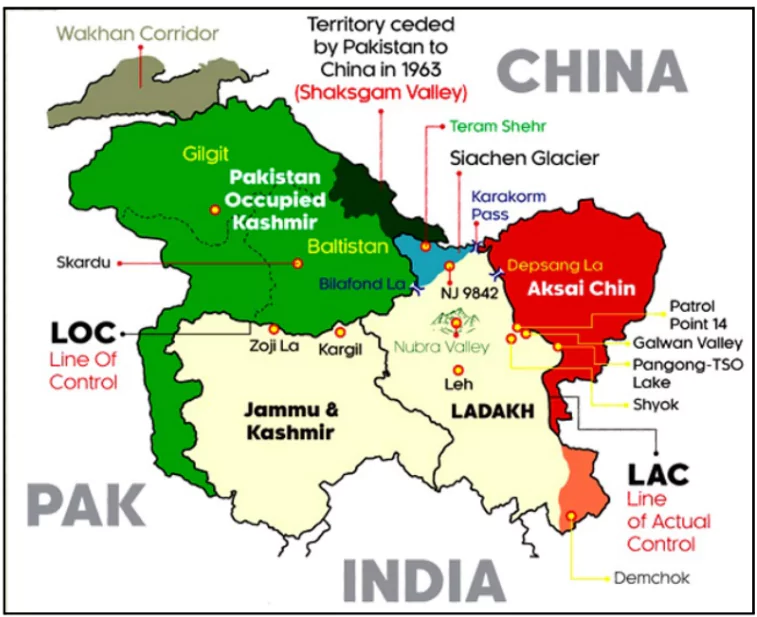
Source: PWOnlyIAS — Siachen Glacier · pwonlyias.com
Strategic & Geographic Significance
Altitude: Ranges from 5,400 to 7,000+ meters above sea level
Climate: Temperatures drop to -50°C in winter, making it world's highest battlefield
Water Source: Feeds the Nubra River which joins Shyok River (Indus system)
Military Importance: Controlled by India since Operation Meghdoot (1984)
Access Route: Nubra Valley serves as the gateway to Siachen via Khardung La Pass
Trap: Confusing Siachen's position - remember it's NORTH of Nubra Valley, not south
Trap: Mixing up Aksai Chin (China-controlled, northeast of Siachen) vs Siachen (India-controlled)
Trap: Gilgit is in Pakistan-controlled territory, west of Siachen - not the other way around
Geography Trick: Follow the water flow - Siachen (source) → Nubra River → Nubra Valley → Shyok → Indus
Nubra Valley
Geography Nubra Valley
Nubra Valley: Gateway to Siachen & Strategic Location
Cold desert valley in Ladakh at 10,000+ feet altitude
Located south of Siachen Glacier - serves as gateway to Siachen
Nubra River (originates from Siachen) flows through this valley
Accessible via Khardung La Pass from Leh
Geographic Position
Nubra Valley is a tri-armed valley located north of Leh in Ladakh. It lies between the Ladakh Range and Karakoram Range. The valley gets its name from 'Ldumra' meaning 'valley of flowers' in the local Ladakhi language.
River System Connection
%%{init: {"flowchart": {"wrappingWidth": 460}}}%%
flowchart TD
  s1["`****Siachen Glacier** (North)**
Source of meltwater at 5,400+ meters`"]
  s2["`****Nubra River** Formation**
Fed by Siachen meltwater and other tributaries`"]
  s3["`****Nubra Valley** (South)**
River flows through this cold desert valley`"]
  s4["`****Shyok River** Confluence**
Nubra joins Shyok near Diskit`"]
  s5["`****Indus River System****
Shyok ultimately joins the Indus`"]
  s1 --> s2
  s2 --> s3
  s3 --> s4
  s4 --> s5
Key Features & Importance
Double-humped Bactrian camels - unique to this region in India
Sand dunes at Hunder - creating a desert landscape at high altitude
Diskit Monastery - oldest and largest monastery in Nubra Valley
Strategic location - gateway for accessing Siachen and Karakoram Pass
Agriculture - barley, wheat, and vegetables grown using glacier meltwater
Direction Trap: Nubra is south of Siachen, but north of Leh - don't confuse the references
River Confusion: Nubra River originates from Siachen - not the other way around
Access Route: Reached via Khardung La from Leh, not directly from Siachen
Karakoram Range Geography
Geography
Karakoram Range: Trans-Himalayan Mountain System
Trans-Himalayan range extending across India, Pakistan, and China borders
Houses Siachen Glacier and several 8,000+ meter peaks including K2
Forms the watershed between Central Asian and Indian Ocean drainage
Geographic Extent
The Karakoram Range is part of the Trans-Himalayan mountain system, extending 500+ km across the borders of India (Ladakh), Pakistan, and China (Xinjiang). It lies north of the Greater Himalayas and forms a crucial strategic and geographic barrier.
Karakoram vs Other Himalayan Ranges
Range | Location | Key Features | Strategic Significance |
|---|---|---|---|
Karakoram | Trans-Himalayan | Siachen, K2, heavily glaciated | India-Pakistan-China trijunction |
Ladakh Range | Trans-Himalayan | Khardung La, parallel to Indus | Separates Indus and Shyok valleys |
Zanskar Range | Trans-Himalayan | Zanskar Valley, high passes | Between Ladakh and Greater Himalayas |
Greater Himalayas | Main Himalayan | Highest peaks (8,000m+) | India-Tibet watershed |
Major Peaks & Glaciers
K2 (8,611m) - world's second-highest peak, on Pakistan side
Siachen Glacier - longest glacier in Karakoram, strategically important
Baltoro Glacier - feeds into Indus river system via Shigar River
Karakoram Pass (5,540m) - historic trade route to Central Asia
Saltoro Ridge - forms the actual Line of Control in Siachen sector
Ladakh Strategic Geography
Geography Leh Aksai Chin Gilgit
Ladakh's Strategic Geography & Border Areas
Union Territory since 2019, sharing borders with China and Pakistan
Leh is the administrative headquarters and largest town
Aksai Chin (China-controlled) and Gilgit-Baltistan (Pakistan-controlled) are disputed areas
Ladakh's Border Geography
# Ladakh UT
## **China Border**
- **Aksai Chin** (China-controlled)
- **Line of Actual Control**
- **Galwan Valley**
- **Pangong Tso**
## **Pakistan Border**
- **Gilgit-Baltistan** (PoK)
- **Siachen Glacier**
- **Line of Control**
- **Saltoro Ridge**
## **Key Towns**
- **Leh** (HQ)
- **Kargil**
- **Nubra Valley**
- **Zanskar**
Strategic Areas Around Siachen
Area | Control Status | Direction from Siachen | Strategic Importance |
|---|---|---|---|
Aksai Chin | China-controlled disputed | Northeast | Part of China-Pakistan Economic Corridor |
Gilgit-Baltistan | Pakistan-controlled (PoK) | West | Gateway to Central Asia for Pakistan |
Nubra Valley | India-controlled | South | Gateway to Siachen for India |
Leh | India-controlled | Southwest | Administrative & military headquarters |
Aksai Chin Trap: It's northeast of Siachen, not east - and it's China-controlled, not Indian
Gilgit Confusion: Gilgit is in Pakistan-controlled territory, west of Siachen
Leh Direction: Leh is southwest of Siachen, accessible via Nubra Valley route