Which one of the following is the best example of repeated falls in sea level, giving rise to present-day extensive marshland?
Contents14
- ABhitarkanika Mangroves
- BMarakkanam Salt Pans
- CNaupada Swamp
- DRann of Kutch
Show answer
Answer: (D) Rann of Kutch
The Rann of Kutch is the best example.
It was once part of the Arabian Sea, but repeated geological shifts cut off the sea connection.
Over time, it became a seasonal marshy salt desert.
During monsoons it fills with water; in summer it dries into a white, salty flatland.
Answer is (d) Rann of Kutch.
The Rann of Kutch is a massive seasonal salt marsh of about 23,000 square kilometers that was formed when repeated geological changes cut off its connection to the Arabian Sea.
Unlike typical mangroves or swamps that formed through river deltas, the Rann shows how geological uplift can transform a sea area into marshland over geological time.
The question tests understanding of different marsh formation processes - tectonic versus deltaic versus coastal erosion origins.
Rann of Kutch
Geography Rann of Kutch
Rann of Kutch: Formation by Sea Level Falls & UPSC Facts
Rann of Kutch was once part of the Arabian Sea but got cut off by geological shifts
Seasonal salt marsh — floods during monsoon, dries into white salt desert in summer
Best example of repeated sea level falls creating extensive marshland
Located in Gujarat, covers approximately 30,000 sq km
What is Rann of Kutch
The Rann of Kutch is a massive seasonal salt marsh in Gujarat, formed when repeated geological shifts cut off its connection to the Arabian Sea. Unlike permanent wetlands, it transforms dramatically with seasons — flooding during monsoons and becoming a white, crystalline salt desert in summer.
Seasonal Transformation
Season | Water Status | Appearance | Accessibility |
|---|---|---|---|
Monsoon (June-Sep) | Flooded with seawater | Shallow water body | Limited access |
Winter (Oct-Mar) | Gradually drying | Muddy, marshy terrain | Rann Utsav festival time |
Summer (Apr-May) | Completely dry | White salt crust | Vehicle movement possible |
Formation Process
%%{init: {"flowchart": {"wrappingWidth": 460}}}%%
flowchart TD
  s1["`**Ancient Connection**
**Rann of Kutch** was part of **Arabian Sea**`"]
  s2["`**Geological Shifts**
**Repeated sea level falls** and tectonic activity`"]
  s3["`**Sea Connection Cut**
Land barriers formed, isolating the water body`"]
  s4["`**Salt Accumulation**
Evaporation left behind **salt deposits**`"]
  s5["`**Present Form**
**Seasonal salt marsh** — floods and dries cyclically`"]
  s1 --> s2
  s2 --> s3
  s3 --> s4
  s4 --> s5
Rann Geography
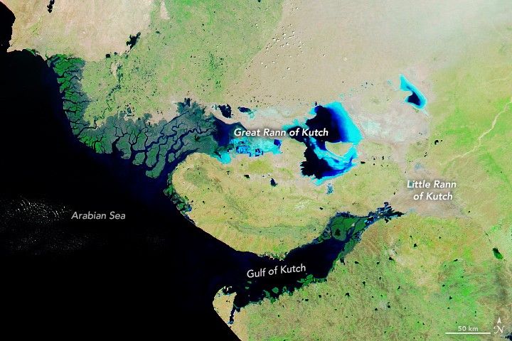
Source: NASA Science — India's White Desert - NASA Science · science.nasa.gov
Why This Answers the Question
UPSC asked for the best example of repeated falls in sea level creating marshland. The Rann's geological history of being cut off from the Arabian Sea through multiple sea level changes, combined with its current status as extensive seasonal marshland, makes it the perfect answer.
Bhitarkanika is a natural mangrove, not formed by sea level falls
Marakkanam are artificial salt pans, not geological formations
Naupada Swamp is a freshwater wetland, not created by marine regression
Only Rann of Kutch has the specific history of sea level falls creating marshland
Other Indian Wetlands
Geography Bhitarkanika Mangroves Marakkanam Salt Pans Naupada Swamp
Bhitarkanika, Marakkanam & Naupada: Wetland Types Comparison
Bhitarkanika — natural mangrove ecosystem in Odisha deltaic region
Marakkanam — artificial salt production pans in Tamil Nadu
Naupada Swamp — freshwater wetland, not formed by sea level changes
Wetland Comparison
Wetland | Location | Type | Formation | Key Feature |
|---|---|---|---|---|
Bhitarkanika | Odisha | Mangrove | Natural deltaic formation | Saltwater crocodile habitat |
Marakkanam | Tamil Nadu | Salt Pans | Artificial for salt production | Commercial salt extraction |
Naupada | Odisha | Swamp | Natural freshwater wetland | Bird sanctuary status |
Rann of Kutch | Gujarat | Salt Marsh | Sea level falls | Seasonal transformation |
Why They Don't Fit
Bhitarkanika Mangroves formed through natural deltaic processes, not sea level regression
Marakkanam Salt Pans are human-made for commercial salt production
Naupada Swamp is a freshwater ecosystem without marine geological history
None show the specific pattern of repeated sea level falls creating marshland
Don't confuse natural mangroves (Bhitarkanika) with sea level formation (Rann)
Salt pans ≠ salt marshes — one is artificial, other is geological
Freshwater swamps cannot be formed by sea level changes
Sea Level Changes & Landforms
Geography sea level marshland
Sea Level Changes: How They Create Coastal Landforms
Marine regression (sea level fall) exposes former seabed as marshlands
Marine transgression (sea level rise) creates submergence features
Repeated cycles create complex coastal formations like Rann of Kutch
Sea Level Mechanism
Sea level changes occur due to geological processes, climate variations, and tectonic movements. When sea levels fall repeatedly, former sea floors become exposed land, often retaining salt deposits and creating seasonal marshlands.
Sea Level Change Effects
Process | Sea Level | Landform Created | Example in India |
|---|---|---|---|
Marine Regression | Falls | Salt marshes, exposed shelves | Rann of Kutch |
Marine Transgression | Rises | Rias, fjords, drowned valleys | Konkan coast |
Repeated Cycles | Rise & fall | Complex marshlands | Kutch formation |
Stable Level | No change | Beach plains, deltas | Ganga delta |
Marshland Formation
%%{init: {"flowchart": {"wrappingWidth": 460}}}%%
flowchart TD
  s1["`**High Sea Level**
Area is part of sea/ocean`"]
  s2["`**Sea Level Falls**
**Marine regression** exposes seabed`"]
  s3["`**Salt Accumulation**
Evaporation leaves **salt deposits**`"]
  s4["`**Repeated Cycles**
Multiple rise-fall cycles create complex terrain`"]
  s5["`**Present Marshland**
**Seasonal flooding** with permanent salt deposits`"]
  s1 --> s2
  s2 --> s3
  s3 --> s4
  s4 --> s5
UPSC Connection
Rann of Kutch is India's best example of sea level regression creating marshland
Understanding marine regression vs transgression helps identify coastal landform origins
Repeated geological processes create more complex formations than single events