Which one of the following pairs of States of India indicates the easternmost and westernmost State?
Contents12
- AAssam and Rajasthan
- BArunachal Pradesh and Rajasthan
- CAssam and Gujarat
- DArunachal Pradesh and Gujarat
Show answer
Answer: (D) Arunachal Pradesh and Gujarat
As per NCERT Class 11 (India: Physical Environment, Page 2):
'The mainland of India extends from Kashmir in the north to Kanyakumari in the south and Arunachal Pradesh in the east to Gujarat in the west.'
So the easternmost state is Arunachal Pradesh and the westernmost state is Gujarat.
Common mistakes:
- Many students confuse Assam with Arunachal Pradesh — but Assam lies to the west of Arunachal Pradesh.
- Similarly, Rajasthan might seem westernmost on a casual glance, but Gujarat's Kutch region extends further west than Rajasthan.
Remember this simple fact:
- East = Arunachal Pradesh
- West = Gujarat
- North = Jammu & Kashmir
- South = Kanyakumari (Tamil Nadu).
Arunachal Pradesh extends furthest east due to its border with Myanmar and China, while Gujarat's Kutch region extends furthest west into the Arabian Sea.
Students commonly confuse Assam with Arunachal Pradesh for the east, and Rajasthan with Gujarat for the west, because they don't know the precise geographic boundaries of these border states.
Extreme Points of India
Geography easternmost westernmost Arunachal Pradesh Gujarat
Extreme Points of India: Cardinal Boundaries & UPSC Traps
Easternmost: Arunachal Pradesh (mainland India)
Westernmost: Gujarat (Kutch region extends furthest west)
Northernmost: Jammu & Kashmir
Southernmost: Kanyakumari, Tamil Nadu (mainland)
Assam lies west of Arunachal Pradesh — common UPSC trap
NCERT Foundation
India's mainland extends in four cardinal directions from specific states. The NCERT Class 11 clearly states: 'Kashmir in the north to Kanyakumari in the south and Arunachal Pradesh in the east to Gujarat in the west.' This is the authoritative source for UPSC questions on India's extreme points.
Four Extreme Points
Direction | State/Place | Key Geographic Feature | Common Confusion |
|---|---|---|---|
North | Jammu & Kashmir | Siachen Glacier region | None |
South | Tamil Nadu (Kanyakumari) | Cape Comorin | Students forget it's mainland southernmost |
East | Arunachal Pradesh | Kibithu near China border | Often confused with Assam |
West | Gujarat | Kutch district | Rajasthan appears western but isn't extreme |
India's Extreme Points
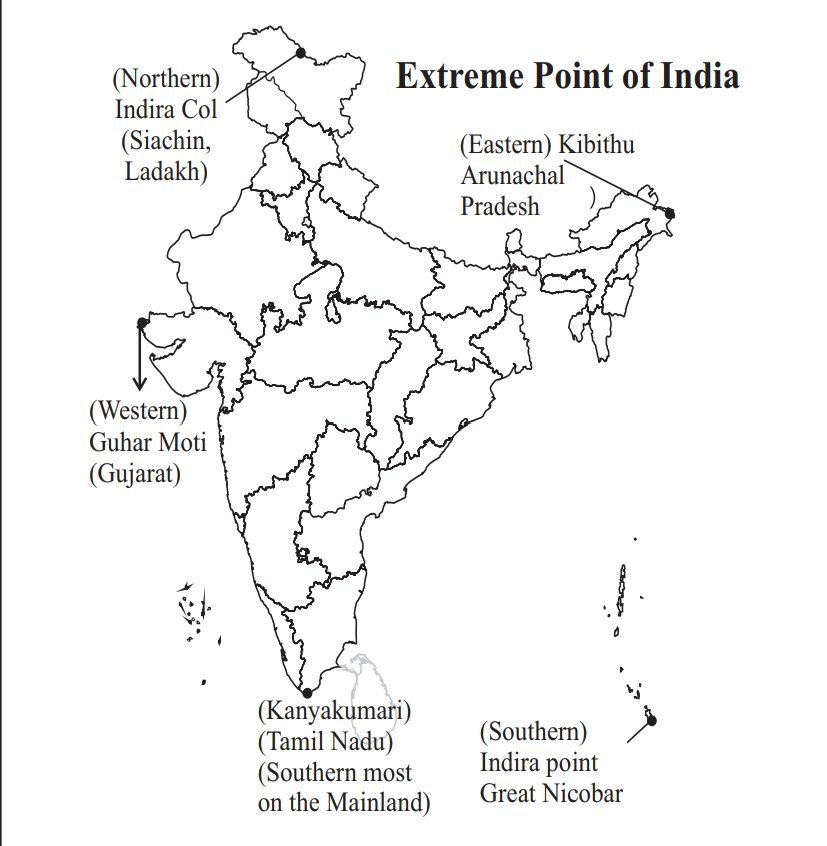
Source: x.com — 🎯The four extreme points of India are- 1. Southernmost Point ... · x.com
Assam vs Arunachal Pradesh: Assam lies to the west of Arunachal Pradesh — not the easternmost state
Rajasthan vs Gujarat: Gujarat's Kutch region extends further west than any part of Rajasthan
Southernmost confusion: Kanyakumari is mainland India's southernmost point; Indira Point (Andaman) is the absolute southernmost
Mnemonic trap: 'RING' doesn't work — it's Rajasthan-Indira Point-Nagaland-Gujarat but Nagaland isn't northernmost
Northeast Indian States Geography
Geography Arunachal Pradesh Assam
Northeast States: Locations & Border Geography
Arunachal Pradesh: Easternmost state, borders China & Myanmar
Assam: Central northeast state, surrounds Meghalaya
Seven Sisters: Assam, Meghalaya, Tripura, Mizoram, Manipur, Nagaland, Arunachal Pradesh
Sikkim is the 8th northeast state (not a Sister state)
Regional Context
The Northeast comprises eight states connected to mainland India through the narrow Siliguri Corridor (Chicken's Neck). Arunachal Pradesh is the largest by area and forms India's eastern frontier with China and Myanmar.
Key Northeast States Comparison
State | Location | International Borders | Capital | Special Feature |
|---|---|---|---|---|
Arunachal Pradesh | Easternmost India | China, Myanmar | Itanagar | Largest northeast state |
Assam | Central northeast | Bhutan | Dispur | Tea gardens, Brahmaputra valley |
Nagaland | Eastern border | Myanmar | Kohima | Smallest northeast state |
Manipur | Southeast | Myanmar | Imphal | Loktak Lake |
Sikkim | Northern hills | China, Bhutan | Gangtok | Not a Sister state |
Northeast Organization
# Northeast India (8 States)
## Seven Sisters
- Arunachal Pradesh
- Assam
- Meghalaya
- Manipur
- Mizoram
- Nagaland
- Tripura
## Added Later
- Sikkim (1975)
## Eastern Border
- Arunachal Pradesh
- Nagaland
- Manipur
- Mizoram
## Northern Border
- Arunachal Pradesh
- Sikkim
Western States Geography
Geography Gujarat Rajasthan
Western States: Rajasthan vs Gujarat Positioning
Gujarat: Westernmost state due to Kutch region extension
Rajasthan: Largest state by area but not westernmost
Arabian Sea coastline: Gujarat has longest western coast
Both states share Thar Desert region
Geographic Context
While Rajasthan is India's largest state, Gujarat extends furthest west due to its Kutch district. Gujarat also has extensive Arabian Sea coastline, making it strategically important for western trade routes and ports.
Rajasthan vs Gujarat
Aspect | Rajasthan | Gujarat |
|---|---|---|
Area Rank | 1st (largest state) | 5th largest |
Western Extension | Not extreme west | Westernmost (Kutch) |
Coastline | Landlocked | 1,600 km Arabian Sea coast |
Capital | Jaipur | Gandhinagar |
Major Desert | Thar Desert (main area) | Kutch desert region |
International Border | Pakistan | Pakistan (short border) |
Western India Geography
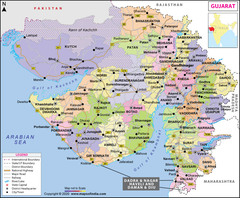
Source: India Map — Gujarat Map | Map of Gujarat - State, Districts Information and Facts · www.mapsofindia.com
Size illusion: Rajasthan is largest by area but Gujarat extends furthest west
Kutch importance: Gujarat's westernmost position is due specifically to Kutch district
Desert confusion: Both have desert regions, but this doesn't determine western extremity