The Brahmaputra, Irrawady and Mekong rivers originate in Tibet and flow through narrow and parallel mountain ranges in their upper reaches. Of these rivers, Brahmaputra makes a "U" turn in its course to flow into India. This "U" turn is due to
Contents15
- AUplift of folded Himalayan series
- BSyntaxial bending of geologically young Himalayas
- CGeo-Tectonic disturbance in the tertiary folded mountain chains
- DBoth (a) and (b) above
Show answer
Answer: (B) Syntaxial bending of geologically young Himalayas
The Brahmaputra's dramatic U-turn near Namcha Barwa (where it bends from east-to-west flow in Tibet to south flow into India) is caused by SYNTAXIAL BENDING of the young Himalayas.
What is syntaxial bending?
At the extreme eastern end of the Himalayas, the mountain ranges curve sharply — like the end of a hairpin. This geological bending forced the Brahmaputra to change direction dramatically. Think of it like a river hitting a wall and being forced to turn.
Option (a) — 'Uplift of folded Himalayas' — is too general; uplift happened everywhere in the Himalayas, not just where the U-turn occurs.
Option (c) — 'Geo-tectonic disturbance' — is also too vague. The specific geological term for this phenomenon is syntaxial bending, making (b) the most precise and correct answer.
The Brahmaputra's U-turn at Namcha Barwa is where the river changes from flowing east-west in Tibet to flowing south into India, creating one of the world's most dramatic river course changes.
Syntaxial bending refers to the sharp hairpin-like curving of mountain ranges at their ends, which is exactly what happens at the eastern terminus of the Himalayas where they bend around the Tibetan plateau.
Brahmaputra River Course & U-Turn
Geography Brahmaputra U turn Tibet
Brahmaputra's U-Turn: From Tibet to India
Brahmaputra makes a dramatic U-turn at Namcha Barwa peak due to syntaxial bending
Known as Yarlung Tsangpo in Tibet, flows east-west before turning south into India
The U-turn occurs at the eastern syntaxis of the Himalayas
Total length: 2,900 km (Tibet: 1,625 km, India: 918 km, Bangladesh: 337 km)
The Great U-Turn
The Brahmaputra originates from Chemayungdung glacier on Kailash range in Tibet and flows eastward as Yarlung Tsangpo for over 1,600 km. At Namcha Barwa peak (7,782m), it makes a spectacular 180-degree turn and cuts through the Himalayas to enter India as Brahmaputra.
• In Tibet: Flows east-west parallel to the Himalayas
• At Namcha Barwa: Makes the dramatic U-turn southward
• In India: Flows through Arunachal Pradesh and Assam
Brahmaputra Course Map
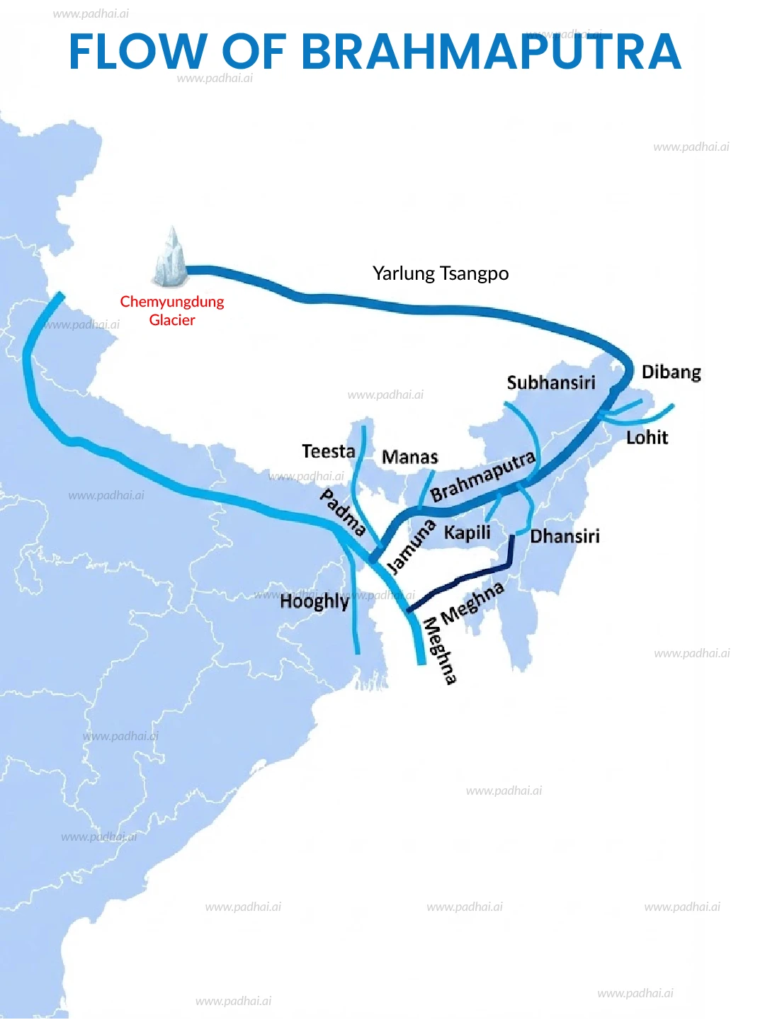
Source: PadhAI.ai — Brahmaputra River Map | PDF & Image Download · padhai.ai
Trap: Don't confuse Brahmaputra's U-turn with the general Himalayan uplift — it's specifically due to syntaxial bending
Trap: The river is Yarlung Tsangpo in Tibet, Brahmaputra in India — same river, different names
Trap: The U-turn happens at Namcha Barwa peak, not just anywhere in the eastern Himalayas
Syntaxial Bending of Himalayas
Geography Syntaxial bending geologically young Himalayas
Syntaxial Bending: Why Rivers Change Course
Syntaxial bending = sharp curving of mountain ranges at their extremities
Occurs at eastern and western ends of the Himalayan arc
Forces rivers to make dramatic directional changes like Brahmaputra's U-turn
Result of young geological age of Himalayas and ongoing tectonic activity
What is Syntaxial Bending?
Syntaxial bending refers to the sharp curving or hairpin-like bending of mountain ranges at their extremities. In the Himalayas, this phenomenon occurs at both the eastern and western ends where the mountain ranges curve dramatically.
Himalayan Syntaxes
Location | Peak | River Affected | Direction Change |
|---|---|---|---|
Eastern Syntaxis | Namcha Barwa (7,782m) | Brahmaputra | East-West to South |
Western Syntaxis | Nanga Parbat (8,126m) | Indus | Northwest to South |
Why This Matters for UPSC
Syntaxial bending is the most precise geological term for this phenomenon
General terms like 'uplift' or 'tectonic disturbance' are too vague for UPSC
Understanding syntaxes helps explain antecedent drainage patterns
Both Brahmaputra and Indus show similar patterns at opposite ends
Trap: 'Uplift of Himalayas' happened everywhere — not specific to the U-turn location
Trap: 'Geo-tectonic disturbance' is too general — UPSC wants the specific term 'syntaxial bending'
Trap: Don't think it's unique to Brahmaputra — Indus also shows similar pattern at western syntaxis
Trans-Himalayan Rivers Origin
Geography Irrawady Mekong Tibet narrow and parallel mountain ranges
Major Rivers Originating from Tibet Plateau
Brahmaputra, Irrawady, and Mekong all originate from Tibet plateau
These are antecedent rivers — older than the mountains they cut through
Flow through narrow parallel ranges in upper reaches before spreading out
All three drain into different seas: Bay of Bengal, Andaman Sea, South China Sea
Trans-Himalayan Rivers Comparison
River | Origin in Tibet | Countries Crossed | Final Outlet | Length (km) |
|---|---|---|---|---|
Brahmaputra | Chemayungdung glacier | China, India, Bangladesh | Bay of Bengal | 2,900 |
Irrawady | Confluence of Mali and Nmai rivers | Myanmar | Andaman Sea | 2,170 |
Mekong | Lasagongma Spring | China, Myanmar, Laos, Thailand, Cambodia, Vietnam | South China Sea | 4,350 |
Tibet Rivers Map
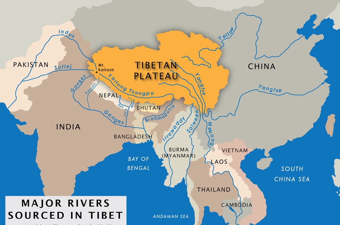
Source: Great Tibet Tour — Top 6 Rivers Rising From Tibetan Plateau · www.greattibettour.com
Antecedent Nature
These rivers are antecedent — they existed before the Himalayan uplift
As mountains rose, rivers cut through them maintaining their original courses
This explains why they flow through narrow gorges in upper reaches
Brahmaputra cuts the deepest gorge at Namcha Barwa — deeper than Grand Canyon
Trap: All three originate in Tibet — don't confuse with rivers originating in Indian Himalayas
Trap: Irrawady flows only through Myanmar — not through India like Brahmaputra
Trap: Mekong crosses 6 countries — most international river in the question set
Himalayan Geological Processes
Geography folded Himalayan series tertiary folded mountain chains geologically young
Himalayas: Geological Formation & Age
Himalayas are geologically young mountains formed in Tertiary period (65-2 million years ago)
Formed by folding due to collision between Indian and Eurasian plates
Uplift process is still ongoing — Himalayas rising by 5mm per year
Folded mountain chains show complex geological structures with nappes and thrusts
Why 'Geologically Young'?
The Himalayas are called geologically young because they formed during the Tertiary period (65-2 million years ago), making them much younger than mountains like the Aravallis (billions of years old). This young age explains their sharp peaks, active tectonics, and ongoing geological processes like syntaxial bending.
Himalayan Formation Process
%%{init: {"flowchart": {"wrappingWidth": 460}}}%%
flowchart TD
  s1["`****Tethys Sea** existed between Indian and Eurasian plates**
200 million years ago`"]
  s2["`****Indian plate** moved northward after Gondwana breakup**
Carrying sediments from Tethys Sea`"]
  s3["`****Collision** between Indian and Eurasian plates began**
65 million years ago (Tertiary period)`"]
  s4["`****Folding and uplift** of sediments created Himalayas**
Ongoing process, still rising 5mm/year`"]
  s5["`****Syntaxial bending** at extremities shaped river courses**
Eastern and western syntaxes formed`"]
  s1 --> s2
  s2 --> s3
  s3 --> s4
  s4 --> s5
Geological Terminology in Options
Folded Himalayan series = refers to the layered rock formations created by folding
Tertiary folded mountain chains = mountains formed during Tertiary geological period
Geo-tectonic disturbance = general term for any geological movement or deformation
Syntaxial bending = specific term for curving at mountain range extremities
Trap: General geological processes don't explain specific phenomena like the U-turn
Trap: UPSC prefers precise geological terms over vague descriptions
Trap: Uplift happens throughout Himalayas — doesn't explain why U-turn occurs only at Namcha Barwa