When you travel in Himalayas, you will see the following: 1. Deep gorges 2. U-turn river courses 3. Parallel mountain ranges 4. Steep gradients causing land-sliding Which of the above can be said to be the evidence for Himalayas being young fold mountains?
Contents19
- A1 and 2 only
- B1, 2 and 4 only
- C3 and 4 only
- D1, 2, 3 and 4
Show answer
Answer: (D) 1, 2, 3 and 4
ALL four features are evidence that the Himalayas are young fold mountains:
Deep gorges (statement 1) — rivers have cut deep V-shaped gorges because the mountains are still rising.
U-turn river courses (statement 2) — rivers like the Brahmaputra make sharp bends, indicating active tectonic uplift.
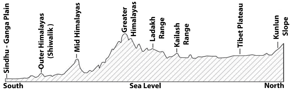
Parallel mountain ranges (statement 3) — the Himadri, Himachal, and Shiwaliks run parallel, showing successive folding.
Steep gradients causing landslides (statement 4) — instability due to ongoing geological activity.
Old mountains (like the Aravallis) are worn down, rounded, and stable.
Young mountains are sharp, unstable, and still being shaped.
Source: NCERT Indian Geography.
Answer: 1, 2, 3 and 4.
Young fold mountains like the Himalayas show active geological processes - steep slopes, deep gorges, and instability - while old mountains like the Aravallis are worn down and stable.
The parallel ranges (Himadri, Himachal, Shiwaliks) and U-turn river courses directly result from ongoing tectonic uplift and folding activity.
This question tests whether students can distinguish between features of young versus old mountain systems using field observations.
Young Fold Mountains Characteristics
Geography young fold mountains Deep gorges U-turn river courses Parallel mountain ranges Steep gradients
Young Fold Mountains: Evidence & Characteristics in UPSC Geography
Young fold mountains show active geological processes — deep gorges, sharp bends, parallel ranges, steep slopes
Himalayas are classic young fold mountains formed by Indo-Australian plate collision with Eurasian plate
All four features (gorges, U-turns, parallel ranges, steep gradients) indicate ongoing tectonic activity
Old mountains like Aravallis are rounded, stable, and worn down by erosion
What Makes Mountains Young
Young fold mountains are formed by recent geological activity — typically within the last 50 million years. Unlike old mountains that have been weathered into gentle slopes, young mountains show signs of active tectonic processes still shaping their landscape.
Active uplift: Mountains still rising due to ongoing plate collision
Sharp features: Steep slopes, pointed peaks, narrow valleys
Geological instability: Frequent earthquakes, landslides, and erosion
Evidence of Young vs Old Mountains
Feature | Young Mountains (Himalayas) | Old Mountains (Aravallis) | Why This Difference |
|---|---|---|---|
Gorges | Deep V-shaped gorges | Shallow U-shaped valleys | Rivers cut faster than erosion can widen |
River courses | Sharp U-turns, meandering | Gentle curves, mature valleys | Active uplift forces rivers to change course |
Mountain arrangement | Parallel ranges | Scattered hills | Successive waves of folding create parallel structure |
Slope gradient | Very steep (>30°) | Gentle slopes (<15°) | Less time for weathering to smooth surfaces |
Geological activity | Earthquakes, landslides | Stable, little seismic activity | Ongoing vs completed tectonic processes |
How Young Mountain Features Form
%%{init: {"flowchart": {"wrappingWidth": 460}}}%%
flowchart TD
  s1["`**Plate Collision**
**Indo-Australian plate** pushes against **Eurasian plate** at 2-5 cm/year`"]
  s2["`**Rock Folding**
Sedimentary layers buckle upward creating **parallel mountain ranges**`"]
  s3["`**Rapid Uplift**
Land rises faster than erosion — creates **steep gradients** and instability`"]
  s4["`**River Adjustment**
Rivers forced into **U-turns** and cut **deep gorges** to maintain flow`"]
  s5["`**Ongoing Instability**
Continued geological activity causes **landslides** and earthquakes`"]
  s1 --> s2
  s2 --> s3
  s3 --> s4
  s4 --> s5
Himalayan Parallel Ranges
Source: NEXT IAS — The Himalayas & Himalayan Ranges: Formation, Division & More · www.nextias.com
Question Analysis
This question tests understanding that ALL four features indicate young mountains — many students incorrectly think some features are just coincidental
Deep gorges prove rivers are cutting faster than the landscape can mature — sign of active uplift
U-turn courses show rivers are constantly adjusting to changing topography due to ongoing mountain building
Parallel ranges (Himadri, Himachal, Shiwaliks) result from successive waves of the same tectonic folding process
Trap: Thinking parallel ranges are not evidence of young mountains — they are created by successive folding waves
Trap: Assuming U-turn river courses are natural river behavior — they indicate active tectonic interference
Trap: Believing only steep gradients indicate young mountains — all four features work together as evidence
Confusion: Deep gorges vs wide valleys — young mountains have narrow, deep cuts; old mountains have wide, gentle valleys
Himalayas Physiographic Divisions
Geography Parallel mountain ranges Himalayas
Himalayas: Three Parallel Ranges & Their Characteristics
Three parallel ranges: Himadri (Greater), Himachal (Lesser), Shiwaliks (Sub-Himalayas) from north to south
Himadri is highest (8000m+) with permanent snow and major peaks like Everest, K2
Himachal has hill stations, ranges from 3700-4500m, includes Pir Panjal, Dhauladhar
Shiwaliks are foothills (600-1500m) with dun valleys like Dehra Dun between ranges
Formation & Structure
The parallel arrangement of Himalayan ranges results from successive waves of folding during the collision between Indo-Australian and Eurasian plates. Each range represents a different phase of mountain building, with the northernmost Himadri being the most recent and highest fold.
Three Himalayan Ranges Comparison
Range | Alternative Name | Elevation | Key Features | Examples |
|---|---|---|---|---|
Himadri | Greater Himalayas | 8000m+ | Permanent snow, glaciers, highest peaks | Everest, K2, Kanchenjunga |
Himachal | Lesser Himalayas | 3700-4500m | Hill stations, temperate climate | Pir Panjal, Dhauladhar, Mussoorie |
Shiwaliks | Sub-Himalayas | 600-1500m | Foothills, dun valleys, river deposits | Dehra Dun, Kotli Dun |
Himalayan Range Organization
# Himalayas
## Himadri (North)
- Continuous range
- Crystalline rocks
- Glacial features
- International border
## Himachal (Middle)
- Discontinuous
- Sedimentary rocks
- Hill stations
- Major rivers originate
## Shiwaliks (South)
- Youngest range
- Loose sediments
- Dun valleys
- Rivers emerge to plains
UPSC Significance
Parallel ranges are direct evidence of young fold mountain formation — created by the same tectonic forces in successive phases
River systems like Ganga, Yamuna emerge from gaps between these ranges onto the northern plains
Climate variation across ranges — arctic conditions in Himadri, temperate in Himachal, subtropical in Shiwaliks
Strategic importance — Himadri forms natural border with China, Himachal contains major hill stations and cantonments
Trap: Confusing Greater/Lesser/Sub with High/Middle/Low — use the correct Himadri/Himachal/Shiwaliks terminology
Trap: Thinking ranges run east-west — they run roughly northwest to southeast across India
Memory aid: Him-A-dri = Alpine (highest), Him-A-chal = Access (hill stations), Shi-wa-liks = Shivaliks = Shifting foothills
Confusion: Dun valleys are between Himachal and Shiwaliks, not between Himadri and Himachal
Mountain Formation Processes
Geography
Mountain Formation: Fold, Block & Volcanic Mountains
Fold mountains form by compression of sedimentary layers during plate collision (Himalayas, Alps, Andes)
Block mountains form by faulting and vertical displacement (Vosges, Black Forest, Satpuras)
Volcanic mountains form by magma accumulation (Mt. Fuji, Vesuvius, Barren Island)
Young mountains are sharp and active; old mountains are rounded and stable
Types of Mountain Formation
Type | Formation Process | Characteristics | Examples | Age Pattern |
|---|---|---|---|---|
Fold Mountains | Plate compression, sediment folding | Parallel ranges, deep valleys | Himalayas, Alps, Rockies | Young: sharp; Old: rounded |
Block Mountains | Vertical faulting, land displacement | Steep one side, gentle other | Vosges, Satpuras, Sierra Nevada | Steep scarps remain visible |
Volcanic Mountains | Magma eruption and accumulation | Conical shape, crater at top | Mt. Fuji, Kilimanjaro, Barren Island | Shape depends on eruption type |
Residual Mountains | Erosion of surrounding areas | Isolated peaks, weathered | Mt. Monadnock, Nilgiris | Very old, heavily eroded |
Fold Mountain Formation
%%{init: {"flowchart": {"wrappingWidth": 460}}}%%
flowchart TD
  s1["`**Sediment Accumulation**
Layers of sedimentary rocks accumulate in ocean basins over millions of years`"]
  s2["`**Plate Convergence**
Two continental plates or oceanic-continental plates move toward each other`"]
  s3["`**Compression & Folding**
Horizontal pressure folds sedimentary layers into **anticlines** (upfolds) and **synclines** (downfolds)`"]
  s4["`**Uplift & Mountain Building**
Continued compression pushes folded rocks upward creating mountain ranges`"]
  s5["`**Erosion & Shaping**
Rivers, glaciers, and weathering carve valleys, peaks, and other landforms`"]
  s1 --> s2
  s2 --> s3
  s3 --> s4
  s4 --> s5
India's Mountain Types
Himalayas — young fold mountains formed by Indo-Australian plate collision, still rising at 2-5 cm/year
Western Ghats — old block mountains (faulted edge of Deccan Plateau), steep western face, gentle eastern slope
Aravallis — very old fold mountains (2.5 billion years), heavily eroded, stable and rounded
Barren Island — India's only active volcanic mountain in Andaman Sea, last erupted in 2017
Trap: Confusing fold mountains with block mountains — folds result from compression, blocks from faulting
Trap: Assuming all old mountains are low — some old mountains like Western Ghats remain high due to resistant rock
Memory aid: FOLD = Forced Ocean Layers During collision; BLOCK = Broken and Lifted Or Crushed Knots
Confusion: Young fold mountains can be anywhere — Andes are young, Appalachians are old fold mountains of same type
Old vs Young Mountains Comparison
Geography
Old vs Young Mountains: Age-based Classification & UPSC Examples
Young mountains (Himalayas): sharp peaks, active tectonics, steep slopes, geological instability
Old mountains (Aravallis, Appalachians): rounded tops, stable, gentle slopes, minimal seismic activity
India examples: Himalayas (young), Western Ghats (middle-aged), Aravallis (very old)
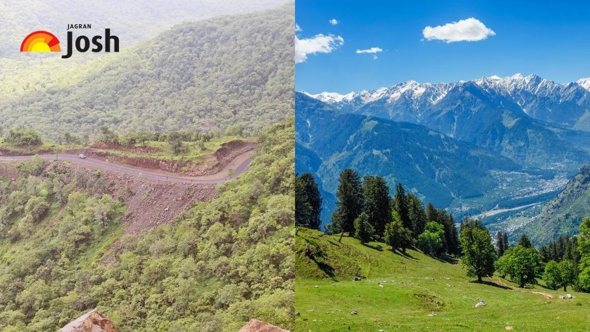
Age threshold: Young (<50 million years), Old (>200 million years), with middle-aged in between
Complete Old vs Young Mountain Comparison
Characteristic | Young Mountains | Old Mountains | Geological Reason |
|---|---|---|---|
Age | <50 million years | 200 million years | Recent vs ancient tectonic activity |
Peak shape | Sharp, pointed, jagged | Rounded, gentle, dome-like | Less time vs more time for weathering |
Slopes | Very steep (>30°) | Gentle (<15°) | Active uplift vs long erosion |
Valleys | Deep V-shaped gorges | Wide U-shaped valleys | Rapid cutting vs mature erosion |
River patterns | Sharp bends, waterfalls | Gentle meandering | Active uplift vs stable base level |
Geological activity | Frequent earthquakes | Seismically stable | Ongoing vs completed tectonics |
Elevation | Very high (8000m+) | Moderate (500-2000m) | Recent uplift vs erosional lowering |
Rock exposure | Crystalline, metamorphic | Weathered, sedimentary cover | Deep rocks uplifted vs surface erosion |
Landslides | Common, frequent | Rare, stable | Steep gradients vs gentle slopes |
Indian Mountain Age Examples
Himalayas (50 million years) — classic young fold mountains, still rising, frequent earthquakes in seismic zones IV-V
Western Ghats (150 million years) — middle-aged block mountains, stable but high due to resistant Deccan basalt
Aravallis (2.5 billion years) — among world's oldest mountains, heavily eroded from 9000m peaks to current 1700m maximum
Eastern Ghats (1.6 billion years) — very old, discontinuous, weathered into separate hill ranges
Mountain Age Comparison
Source: Jagran Josh — List of Top 10 Youngest and Oldest Mountain Ranges in the World 2025 · www.jagranjosh.com
Trap: Assuming high elevation always means young mountains — Western Ghats are middle-aged but remain high due to resistant rock
Trap: Thinking all old mountains are small — Appalachians (old) still reach 2000m+ due to resistant quartzite
Confusion: Seismic activity is key indicator — young mountains have ongoing tectonics, old mountains are seismically quiet
Memory trick: Young mountains look sharp like young people; old mountains look rounded like elderly people