The Narmada river flows to the west, while most other large peninsular rivers flow to the east. Why? 1. It occupies a linear rift valley. 2. It flows between the Vindhyas and the Satpuras. 3. The land slopes to the west from Central India. Select the correct answer using the codes given below.
Contents22
- A1 only
- B2 and 3
- C1 and 3
- DNone
Show answer
Answer: (A) 1 only
Only Statement 1 gives the correct reason.
The Narmada (and the Tapi) flow westward because they flow through linear rift valleys — geological fault-line troughs created by tectonic activity.
The rift valley's alignment determines the direction of flow, which happens to be westward toward the Arabian Sea.
Statement 2 is factually correct — the Narmada does flow between the Vindhyas (to the north) and the Satpuras (to the south).
However, merely flowing between two mountain ranges does not explain WHY it flows west.
Many rivers flow between ranges but in different directions. The rift valley is the actual reason.
Statement 3 is wrong — the land in Central India generally slopes to the EAST (which is why most peninsular rivers like Godavari, Krishna, and Kaveri flow eastward).
The land does NOT slope to the west.
So only statement 1 is correct.
The Narmada and Tapi are the only major peninsular rivers flowing west because they follow linear rift valleys created by tectonic faulting, not because of general land slope.
Most students incorrectly think rivers flow based on general land slope, but the Narmada's westward flow is determined by its specific geological structure - the rift valley alignment overrides the eastward regional slope.
Narmada & Tapi Westward Flow
Geography Narmada west rift valley linear rift valley
Narmada & Tapi: Why They Flow West (Rift Valley Mechanism)
Narmada and Tapi are the only major peninsular rivers flowing westward to Arabian Sea
They flow through linear rift valleys created by tectonic faulting
Rift valley alignment determines westward direction, not topographic slope
Narmada flows between Vindhyas (north) and Satpuras (south)
What Makes Them Different
The Narmada and Tapi are unique among peninsular rivers because they flow westward into the Arabian Sea, while all other major peninsular rivers (Godavari, Krishna, Kaveri) flow eastward into the Bay of Bengal.
Westward vs Eastward Rivers
Direction | Rivers | Destination | Geological Reason |
|---|---|---|---|
Westward | Narmada, Tapi | Arabian Sea | Flow through linear rift valleys |
Eastward | Godavari, Krishna, Kaveri, Mahanadi | Bay of Bengal | Follow eastward slope of peninsula |
Rift Valley Formation Process
%%{init: {"flowchart": {"wrappingWidth": 460}}}%%
flowchart TD
  s1["`**Tectonic Forces**
Earth's crustal movements create stress along fault lines`"]
  s2["`**Land Subsidence**
Portion of land between two parallel faults **sinks down**`"]
  s3["`**Linear Rift Valley**
Long, narrow **depression** formed between uplifted blocks`"]
  s4["`**River Alignment**
Rivers follow the **rift valley direction** → westward flow`"]
  s1 --> s2
  s2 --> s3
  s3 --> s4
Narmada Rift Valley
Cross-sectional diagram showing Narmada river flowing through linear rift valley between Vindhya and Satpura ranges with geological fault lines
Rift valley structure forces Narmada westward — not topographic slope
Question Anchoring
Statement 1 correct: Linear rift valley is the geological reason for westward flow
Statement 2 misleading: Flowing between ranges is a location fact, not the causal explanation
Statement 3 wrong: Central India slopes eastward (hence most rivers flow east), not westward
Trap: Statement 2 sounds correct but doesn't explain WHY Narmada flows west
Trap: Statement 3 reverses the actual slope direction — peninsula slopes east, not west
Trap: Confusing location (between ranges) with geological cause (rift valley)
Peninsular River Drainage Pattern
Geography peninsular rivers east
Peninsular Rivers: Eastward Slope & Drainage Divide
Peninsular India has a general eastward slope from Western Ghats
Most peninsular rivers (Godavari, Krishna, Kaveri) flow eastward to Bay of Bengal
Western Ghats act as the main watershed dividing east-west drainage
Only Narmada & Tapi are major westward flowing rivers
The Eastward Tilt
The Deccan Plateau and broader peninsular India tilt eastward from the Western Ghats toward the Bay of Bengal. This explains why most peninsular rivers naturally flow east, following the slope of the land.
Major Peninsular Rivers by Direction
Eastward (Bay of Bengal) | Westward (Arabian Sea) | Length | Key States |
|---|---|---|---|
Godavari | ~1465 km | Maharashtra, Telangana, AP | |
Krishna | ~1400 km | Maharashtra, Karnataka, AP | |
Kaveri | ~805 km | Karnataka, Tamil Nadu | |
Mahanadi | ~858 km | Chhattisgarh, Odisha | |
Narmada | ~1312 km | MP, Gujarat | |
Tapi | ~724 km | Maharashtra, Gujarat |
Peninsular Drainage System
# Peninsular Rivers
## **Eastward Flow**
- Follow **eastward slope**
- Originate near **Western Ghats**
- Form large **deltas**
- Longer courses
## **Westward Flow**
- Through **rift valleys**
- Narmada & Tapi only
- Form **estuaries**
- Shorter courses
## **Western Ghats**
- Main **watershed**
- Divides east-west drainage
- Source of most rivers
- Higher elevation
Peninsula Drainage Map
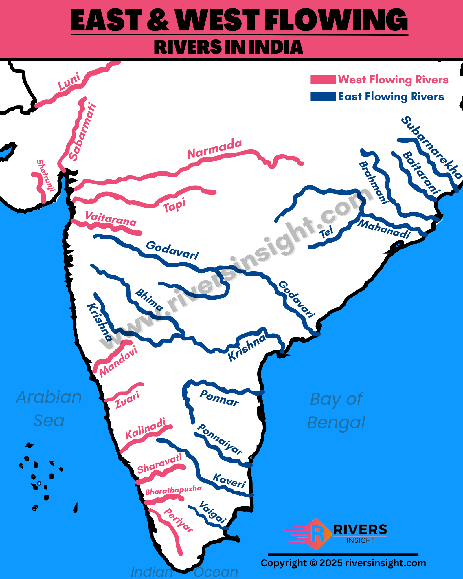
Source: Rivers Insight — East and West Flowing Rivers in India: Map & Differences - Rivers ... · riversinsight.com
Trap: Assuming all peninsular rivers flow east — Narmada & Tapi are major exceptions
Trap: Confusing Western Ghats with source vs rift valleys as flow direction cause
Trap: Thinking westward rivers are longer — they're actually shorter than eastward ones
Vindhya & Satpura Ranges
Geography Vindhyas Satpuras
Vindhya & Satpura Ranges: Central India's Mountain Barriers
Vindhyas lie north of Narmada valley in MP, Rajasthan, UP
Satpuras lie south of Narmada valley in MP, Maharashtra
Narmada rift valley separates these two ancient mountain systems
Both are fold mountains formed in pre-Cambrian times
Geographic Position
The Vindhyas and Satpuras are two parallel mountain ranges in Central India, separated by the Narmada rift valley. The Narmada flows between them but this location doesn't explain its westward direction.
Vindhya vs Satpura Comparison
Feature | Vindhya Range | Satpura Range |
|---|---|---|
Position | North of Narmada | South of Narmada |
States | MP, Rajasthan, UP, Bihar | MP, Maharashtra, Gujarat |
Highest Peak | Sad-bhavna Shikhar (752m) | Dhupgarh (1350m) |
Direction | East-West alignment | East-West alignment |
Rock Type | Sandstone, quartzite | Basalt, granite, sandstone |
Key Hills | Bhander, Kaimur | Mahadeo, Maikala |
Central Highland System
# Central Indian Highlands
## **Vindhya Range**
- North of Narmada
- Lower elevation
- Malwa Plateau connection
- Historical barrier
## **Narmada Valley**
- Rift valley
- Westward drainage
- Natural divide
- Tectonic origin
## **Satpura Range**
- South of Narmada
- Higher peaks
- Deccan edge
- Rich minerals
Why Location ≠ Causation
Statement 2 trap: Narmada flowing 'between ranges' is geographically correct but doesn't explain westward flow
Many rivers flow between mountain ranges in different directions based on geological structure
The rift valley geology, not the mountain position, determines Narmada's westward course
Tapi also flows west through different terrain, proving rift valleys are the key factor
Trap: Statement 2 gives location but not the geological reason for westward flow
Trap: Confusing Vindhya-Satpura orientation with rift valley as the flow determinant
Trap: Thinking mountain barriers direct flow — it's the valley structure that matters
Rift Valley Formation & Types
Geography linear rift valley
Rift Valleys: Tectonic Formation & River Control
Rift valleys form when land subsides between two parallel faults
Linear rift valleys have straight alignment that controls river direction
Narmada-Tapi rift system is India's major example of rift valley rivers
East African Rift is the world's most famous rift valley system
Tectonic Mechanism
A rift valley forms when tectonic forces cause the land between two parallel fault lines to subside (sink down). This creates a long, narrow depression that rivers naturally follow.
Rift Valley Formation Process
%%{init: {"flowchart": {"wrappingWidth": 460}}}%%
flowchart TD
  s1["`****Tectonic Stress****
Crustal movements create tension along fault zones`"]
  s2["`****Parallel Faulting****
Two parallel **fault lines** develop due to tectonic forces`"]
  s3["`****Block Subsidence****
Land between faults **sinks down** forming depression`"]
  s4["`****Linear Valley****
Long, straight **rift valley** with steep sides formed`"]
  s5["`****River Capture****
Rivers follow the **valley alignment** → directional flow`"]
  s1 --> s2
  s2 --> s3
  s3 --> s4
  s4 --> s5
Types of Valleys & River Response
Valley Type | Formation | River Behavior | Indian Example |
|---|---|---|---|
Rift Valley | Tectonic subsidence | Follows valley alignment | Narmada, Tapi |
River Valley | Water erosion | Follows topographic slope | Godavari, Krishna |
Glacial Valley | Ice erosion | Follows pre-glacial course | Kashmir valleys |
Structural Valley | Rock weakness | Follows geological strike | Some Himalayan rivers |
Rift Valley Structure

Source: Geology In — Rift Valleys: Formation, Pictures, and Examples – Geology In · www.geologyin.com
Global Examples
East African Rift: World's largest active rift system with lakes and rivers
Rhine Rift Valley: Controls Rhine River's north-south course through Europe
Dead Sea Rift: Creates lowest point on Earth's land surface
Narmada-Tapi System: India's primary example of rift-controlled drainage
Trap: Confusing rift valleys (tectonic) with river valleys (erosional)
Trap: Thinking topographic slope determines all river directions — geological structure can override slope
Trap: Missing that valley alignment matters more than surrounding mountain positions