Which of the following is/are tributary/ tributaries of Brahmaputra? 1. Dibang 2. Kameng 3. Lohit Select the correct answer using the code given below.
Contents13
- A1 only
- B2 and 3 only
- C1 and 3 only
- D1, 2 and 3
Show answer
Answer: (D) 1, 2 and 3
Answer: (d) 1, 2 and 3
All three - Dibang, Kameng, and Lohit - are tributaries of the Brahmaputra river in northeastern India.
- Dibang - Joins Brahmaputra in Arunachal Pradesh, originates near Keya Pass.
- Kameng (called Jia Bharali in Assam) - Originates in Tawang district, Arunachal Pradesh.
- Lohit - Joins near Sadiya in Assam, originates in eastern Tibet.
Other Brahmaputra tributaries:
- North bank - Subansiri (largest), Manas, Sankosh.
- South bank - Dibang, Lohit, Dhansiri, Kopili.
Brahmaputra's different names:
- Tsangpo (Tibet),
- Siang/Dihang (Arunachal),
- Brahmaputra (Assam),
- Jamuna (Bangladesh).
Source: NCERT Class XI, 'India: Physical Environment.'
The Brahmaputra receives numerous tributaries from Arunachal Pradesh and Assam, making it one of India's largest river systems by volume.
Northeast India development projects and border infrastructure frequently reference these tributary names, making Brahmaputra geography relevant for current affairs.
UPSC tests whether students can distinguish between major and minor tributaries and know the specific names of northeastern rivers.
Brahmaputra Tributaries
Geography Dibang Kameng Lohit tributaries Brahmaputra
Brahmaputra Tributaries: North Bank vs South Bank Classification
Dibang, Kameng, Lohit are all Brahmaputra tributaries from Arunachal Pradesh
North bank tributaries: Subansiri (largest), Kameng, Manas, Sankosh
South bank tributaries: Dibang, Lohit, Dhansiri, Kopili
Kameng is called Jia Bharali in Assam plains
Why This Classification Matters
The Brahmaputra receives tributaries from both banks as it flows through northeastern India. Understanding the north bank vs south bank distinction helps identify tributary origins and their geographic significance in UPSC questions.
Major Brahmaputra Tributaries
Tributary | Bank | Origin | Confluence Point | Alternative Name |
|---|---|---|---|---|
Subansiri | North | Tibet Plateau | Lakhimpur, Assam | Gold River |
Kameng | North | Tawang, Arunachal Pradesh | Sonitpur, Assam | Jia Bharali |
Manas | North | Bhutan Himalayas | Barpeta, Assam | - |
Sankosh | North | Bhutan | Assam-West Bengal border | - |
Dibang | South | Keya Pass, Arunachal Pradesh | Pasighat, Arunachal Pradesh | - |
Lohit | South | Eastern Tibet | Sadiya, Assam | - |
Dhansiri | South | Nagaland hills | Golaghat, Assam | - |
Kopili | South | Meghalaya plateau | Nagaon, Assam | - |
Brahmaputra Basin Map
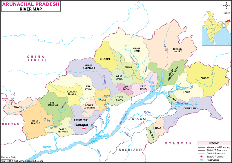
Source: India Map — Arunachal Pradesh River Map, Arunachal Pradesh Rivers · www.mapsofindia.com
Question Anchoring
This 2016 UPSC question tested knowledge of all three tributaries - Dibang, Kameng, and Lohit
The trap was assuming only some tributaries were correct, when all three are genuine Brahmaputra tributaries
Students who knew the north bank vs south bank classification could confidently select option D
Kameng = Jia Bharali - same river, different names in Arunachal Pradesh vs Assam
Don't confuse Dibang (south bank) with Subansiri (north bank) - both are major tributaries
Lohit originates in Tibet but joins from the south bank, not north
Subansiri is the largest tributary by volume, not Kameng or Lohit
Brahmaputra River System
Geography Brahmaputra
Brahmaputra River System: Course, Names & Geographic Significance
Tsangpo (Tibet) → Siang/Dihang (Arunachal) → Brahmaputra (Assam) → Jamuna (Bangladesh)
Originates from Angsi Glacier near Mount Kailash in Tibet
Forms world's largest delta with Ganga in Bangladesh (Sundarbans)
Total length 2,880 km, flows through 4 countries (China, India, Bhutan, Bangladesh)
Trans-Himalayan Character
The Brahmaputra is a trans-Himalayan river that cuts through the Himalayas via deep gorges. It demonstrates antecedent drainage - the river existed before the mountain uplift and carved its path through the rising Himalayas.
Brahmaputra Course & Names
%%{init: {"flowchart": {"wrappingWidth": 460}}}%%
flowchart TD
  s1["`****Tsangpo** (Tibet)**
Flows eastward across Tibetan plateau for 1,625 km`"]
  s2["`****Great Bend****
Sharp southward turn around Namcha Barwa peak`"]
  s3["`****Siang/Dihang** (Arunachal)**
Enters India, cuts through Arunachal Pradesh hills`"]
  s4["`****Brahmaputra** (Assam)**
Flows westward through Assam valley, receives major tributaries`"]
  s5["`****Jamuna** (Bangladesh)**
Joins Padma (Ganga) to form Meghna, flows to Bay of Bengal`"]
  s1 --> s2
  s2 --> s3
  s3 --> s4
  s4 --> s5
Brahmaputra vs Other Major Rivers
Feature | Brahmaputra | Ganga | Indus |
|---|---|---|---|
Origin | Angsi Glacier, Tibet | Gangotri Glacier | Mansarovar, Tibet |
Length in India | 916 km | 2,525 km | 1,114 km |
Flow Direction | West (in Assam) | Southeast | Southwest |
Drainage Type | Antecedent | Consequent | Antecedent |
Major Characteristic | Braided channels | Meandering | Seasonal variation |
Delta Type | Arcuate (with Ganga) | Arcuate | Estuarine |
Siang and Dihang are the same river - different local names for Brahmaputra in Arunachal Pradesh
In Assam, Brahmaputra flows westward, not eastward like most Indian rivers
Yarlung Tsangpo is the full Tibetan name - 'Tsangpo' means river in Tibetan
Don't confuse with Brahmaputra (the river) and Brahmaputra (the valley/region)
Northeast India River Systems
Geography
Northeast India River Systems: Beyond Brahmaputra Basin
Barak River drains southern Assam, Manipur, Mizoram (flows to Bangladesh as Meghna)
Rivers flow to Bay of Bengal via Bangladesh (Meghna system)
Imphal River is the main river of Manipur valley
Most northeastern rivers are monsoon-fed with high seasonal variation
Geographic Context
Northeast India has two major river systems: the Brahmaputra basin covering northern areas and the Barak-Meghna basin draining southern regions. Both systems are crucial for the region's agriculture and transportation.
Northeast River Classification
# Northeast India Rivers
## Brahmaputra Basin
- Northern Assam
- Arunachal Pradesh
- Receives Himalayan tributaries
- Flows to Bangladesh
## Barak-Meghna Basin
- Southern Assam
- Manipur
- Mizoram
- Tripura (partly)
## Independent Systems
- Meghalaya plateau streams
- Nagaland hill streams
- Small coastal rivers
Key Northeast Rivers by State
State | Major River | Basin | Key Feature |
|---|---|---|---|
Assam | Brahmaputra | Brahmaputra | Main river, receives multiple tributaries |
Assam (South) | Barak | Meghna | Flows through Cachar district |
Arunachal Pradesh | Siang | Brahmaputra | Brahmaputra's name in the state |
Manipur | Imphal | Barak-Meghna | Drains Imphal valley |
Mizoram | Tlawng | Barak-Meghna | Major river of the state |
Meghalaya | Umiam | Brahmaputra | Plateau drainage |
Tripura | Gomti | Meghna | Flows through Agartala |
Nagaland | Dikhu | Brahmaputra | Tributary of Brahmaputra |
Barak River becomes Meghna in Bangladesh - not part of Brahmaputra system
Manipur River usually refers to Imphal River, the main valley river
Don't assume all northeastern rivers are Brahmaputra tributaries - southern states drain via Barak-Meghna