Two important rivers- one with its source in Jharkhand (and known by a different name in Odisha), and another, with its source in Odisha- merge at a place only a short distance from the coast of Bay of Bengal before flowing into the sea. This is an important site of wildlife and biodiversity and a protected area. Which one of the following could be this?
Contents13
- ABhitarkanika
- BChandipur-on-sea
- CGopalpur-on-sea
- DSimlipal
Show answer
Answer: (A) Bhitarkanika
The answer is Bhitarkanika — a mangrove wetland and wildlife sanctuary in Odisha's Kendrapara district.
Decoding the clues:
- 'River from Jharkhand, known by different name in Odisha' = Brahmani River (called South Koel in Jharkhand).
- 'River with source in Odisha' = Baitarani River (originates in Keonjhar district, Odisha).
These two rivers merge near the coast of Bay of Bengal and flow into the sea through the Bhitarkanika mangroves.
Bhitarkanika is famous for:
- Largest population of saltwater crocodiles in India
- Olive ridley turtle nesting
- Rich mangrove biodiversity
- It's a Ramsar wetland site.
Why not others?
- Chandipur-on-sea — famous for its disappearing sea, not a river confluence.
- Gopalpur-on-sea — a beach town, not a protected river delta.
- Simlipal — an inland tiger reserve/biosphere reserve in Odisha's Mayurbhanj district, far from the coast.
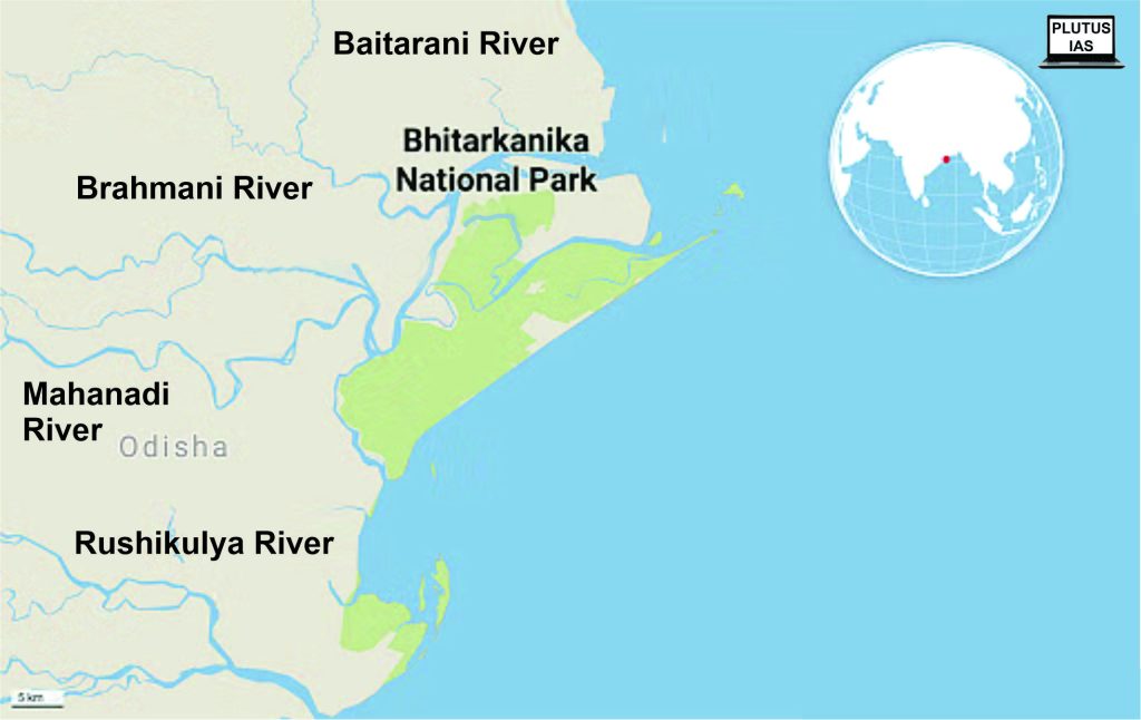
Bhitarkanika National Park in Odisha is where the Brahmani River (called South Koel in Jharkhand) and Baitarani River merge before entering the Bay of Bengal through India's second-largest mangrove system.
This question tests detailed knowledge of Odisha's river systems and protected areas by requiring students to decode geographical clues rather than directly naming the rivers.
UPSC is checking if students can connect river drainage patterns with biodiversity hotspots and distinguish between coastal sanctuaries versus inland reserves.
Bhitarkanika National Park
Geography Bhitarkanika
Bhitarkanika National Park: India's Largest Mangrove Ecosystem
Located in Kendrapara district, Odisha where Brahmani and Baitarani rivers meet Bay of Bengal
India's largest saltwater crocodile population and second-largest mangrove ecosystem after Sundarbans
Ramsar wetland site since 2002, also a National Park and Wildlife Sanctuary
Famous for olive ridley turtle nesting at nearby Gahirmatha Beach
Geographic Setting
Bhitarkanika sits at the delta of two major rivers — the Brahmani and Baitarani — creating a unique estuarine ecosystem where freshwater meets seawater. This river confluence, combined with tidal influence from the Bay of Bengal, creates ideal conditions for mangrove forests to thrive.
Key Features & Significance
Aspect | Details |
|---|---|
Location | Kendrapara district, Odisha |
Area | 672 sq km (National Park: 145 sq km) |
Rivers | Brahmani & Baitarani confluence |
Ecosystem | Mangrove wetlands with 62 mangrove species |
Key Species | Saltwater crocodiles (1,700+), King Cobra, Water Monitor |
Marine Life | Olive Ridley turtles, Horseshoe crabs, dolphins |
Status | National Park (1998), Ramsar Site (2002) |
Delta Location
Source: Plutus IAS — Saltwater CrocodileSaltwater Crocodiles - Plutus IAS · plutusias.com
Question Connection
This question tests knowledge of river confluence sites that form protected ecosystems in coastal India
The clue 'short distance from Bay of Bengal coast' eliminates inland options like Simlipal
Only Bhitarkanika among the options represents a river delta wildlife sanctuary
Don't confuse Bhitarkanika (mangrove delta) with Simlipal (inland tiger reserve) — both are in Odisha
Chandipur-on-sea is famous for disappearing sea phenomenon, not river confluence
Gopalpur-on-sea is a beach town, not a protected wildlife area
Brahmani & Baitarani Rivers
Geography Jharkhand Odisha
Brahmani & Baitarani Rivers: The Bhitarkanika Confluence
Brahmani River originates as South Koel in Jharkhand, changes name in Odisha
Baitarani River originates in Keonjhar district, Odisha from Gonasika hills
Both rivers merge near Bhitarkanika before flowing into Bay of Bengal
River Comparison
River | Origin | Original Name | Length (km) | Key Feature |
|---|---|---|---|---|
Brahmani | Jharkhand (Ranchi plateau) | South Koel River | 799 | Changes name at Odisha border |
Baitarani | Gonasika, Keonjhar (Odisha) | Same name throughout | 360 | Entirely within Odisha |
Combined Delta | Confluence near Bhitarkanika | - | - | Forms mangrove ecosystem |
Question Decoding
The question's clues perfectly match this river system:
'Source in Jharkhand, different name in Odisha' = Brahmani River (called South Koel in Jharkhand)
'Source in Odisha' = Baitarani River
'Merge short distance from coast' = Their confluence near Bhitarkanika
'Protected area with wildlife' = Bhitarkanika National Park
River Journey to Sea
%%{init: {"flowchart": {"wrappingWidth": 460}}}%%
flowchart TD
  s1["`**South Koel originates**
Rises from Jharkhand's Ranchi plateau`"]
  s2["`**Becomes Brahmani**
Name changes upon entering Odisha`"]
  s3["`**Baitarani flows parallel**
Originates and flows entirely within Odisha`"]
  s4["`**Rivers converge**
Meet near Bhitarkanika, close to Bay of Bengal`"]
  s5["`**Delta formation**
Combined flow creates mangrove ecosystem before reaching sea`"]
  s1 --> s2
  s2 --> s3
  s3 --> s4
s4 --> s5Brahmani is the river that changes names — don't confuse with other interstate rivers
Baitarani originates within Odisha — not from neighboring states
The confluence is near the coast, not inland — this eliminates inland protected areas
Odisha's Coastal Protected Areas
Geography Chandipur-on-sea Gopalpur-on-sea Simlipal
Odisha's Coastal Protected Areas: Distinguishing Features
Bhitarkanika is the only river delta wildlife sanctuary among the options
Simlipal is an inland tiger reserve, not coastal
Chandipur & Gopalpur are beach towns, not protected wildlife areas
Comparison of Options
Location | Type | Famous For | Protected Status | River Connection |
|---|---|---|---|---|
Bhitarkanika | Mangrove Delta | Saltwater crocodiles, Olive Ridley turtles | National Park, Ramsar Site | Brahmani-Baitarani confluence |
Chandipur-on-sea | Beach Town | Disappearing sea phenomenon | No major protection | None |
Gopalpur-on-sea | Beach Resort | Tourism, fishing harbor | No major protection | None |
Simlipal | Inland Hills | Tigers, elephants, waterfalls | Tiger Reserve, Biosphere | None (inland location) |
Why Other Options Fail
The question specifically mentions 'merge at a place only short distance from coast' and 'protected area'. Only Bhitarkanika fits both criteria — it's where two rivers actually merge to form a protected ecosystem. The other locations are either inland (Simlipal) or coastal towns without river confluences (Chandipur, Gopalpur).
Key Distinctions
Chandipur-on-sea: Famous for vanishing sea — water recedes up to 5 km during low tide
Gopalpur-on-sea: Historic port town, now primarily a beach resort destination
Simlipal: Located in Mayurbhanj district — completely inland, no coastal connection
Only Bhitarkanika combines river confluence + coastal location + wildlife protection
Don't assume all Odisha options are coastal — Simlipal is inland in Mayurbhanj district
Chandipur's disappearing sea is a unique phenomenon, not a river delta
Beach towns like Gopalpur may be coastal but lack the 'river confluence + protection' criteria