Consider the following statements: 1. The duration of the monsoon decreases from southern India to northern India 2. The amount of annual rainfall in the northern plains of India decreases from east to west Which of the statements given above is/are correct?
Contents17
- A1 only
- B2 only
- CBoth 1 and 2
- DNeither 1 nor 2
Show answer
Answer: (C) Both 1 and 2
Both statements about monsoon patterns are correct:
Statement 1 — Monsoon duration decreases from south to north.
Kerala receives monsoon rains from June to November (5 months), while Punjab-Haryana receives them only from July to September (2-3 months). This is because the monsoon arrives first in the south and withdraws from the north first.
Statement 2 — Rainfall in the northern plains decreases from east to west.
Kolkata receives ~1,500mm, Lucknow ~1,000mm, Delhi ~600mm, and Jaisalmer ~150mm annually. This is because the Bay of Bengal branch of the monsoon progressively loses moisture as it moves westward.
Answer: Both 1 and 2.
The southwest monsoon follows predictable spatial and temporal patterns across India, with southern regions receiving 4-5 months of rainfall while northern plains get only 2-3 months.
The Bay of Bengal branch of monsoon progressively loses moisture as it moves westward, creating a clear east-to-west rainfall gradient from Kolkata's 1500mm to Jaisalmer's 150mm.
This tests understanding of monsoon mechanics - how moisture-laden winds lose water content over land and how seasonal wind shifts affect different regions differently.
Monsoon Duration Patterns in India
Geography duration of the monsoon southern India northern India
Monsoon Duration Patterns: South to North Variation
Monsoon duration decreases from south to north — Kerala gets 5 months, Punjab gets 2-3 months
Southwest monsoon arrives first in southern India (June) and withdraws last from northern India (October)
Kerala: June to November (~5 months), Punjab-Haryana: July to September (~2-3 months)
Why Duration Varies
The southwest monsoon follows a predictable arrival and withdrawal pattern across India. It reaches the southern tip first and gradually advances northward, but withdraws in the reverse order — from north to south.
Regional Duration Comparison
Region | Monsoon Period | Duration | Key Feature |
|---|---|---|---|
Kerala (South) | June to November | ~5 months | First arrival, last withdrawal |
Tamil Nadu (South) | June to December | ~6 months | Gets both SW & NE monsoons |
Maharashtra (West) | June to October | ~4 months | Western Ghats influence |
West Bengal (East) | June to September | ~3-4 months | Bay of Bengal branch |
Punjab-Haryana (North) | July to September | ~2-3 months | Shortest duration |
Monsoon Timeline
%%{init: {"flowchart": {"wrappingWidth": 460}}}%%
flowchart TD
  s1["`**June 1st Week**
Monsoon arrives in **Kerala** — southern tip of India`"]
  s2["`**June 2nd-3rd Week**
Advances to **Karnataka, Goa, Maharashtra** — western coast`"]
  s3["`**End of June**
Covers most of **peninsular India**`"]
  s4["`**Early July**
Reaches **northern plains** — Delhi, Punjab, Haryana`"]
  s5["`**September**
**Withdrawal begins** from northwestern India`"]
  s6["`**October-November**
**Complete withdrawal** from southern India last`"]
  s1 --> s2
  s2 --> s3
  s3 --> s4
  s4 --> s5
s5 --> s6Trap: Assuming longer duration in north because it's farther from sea — wrong direction
Confusion: Tamil Nadu gets longest duration due to both SW and NE monsoons
Statement 1 in question: Tests exact understanding of south to north decrease
Rainfall Distribution in Northern Plains
Geography annual rainfall northern plains decreases from east to west
Northern Plains Rainfall: East-West Gradient
Rainfall in northern plains decreases from east to west — Kolkata 1,500mm to Jaisalmer 150mm
Bay of Bengal branch loses moisture as it moves westward across the Gangetic plains
Delhi gets ~600mm, Lucknow ~1,000mm — clear east-west decline
Why East Gets More Rain
The Bay of Bengal branch of the southwest monsoon carries maximum moisture when it enters India from the east. As it moves westward across the northern plains, it progressively loses moisture through rainfall, leaving less for western regions.
Annual Rainfall Gradient
City | State | Annual Rainfall | Monsoon Branch |
|---|---|---|---|
Kolkata | West Bengal | ~1,500mm | Bay of Bengal (fresh moisture) |
Patna | Bihar | ~1,200mm | Bay of Bengal (moderate loss) |
Lucknow | Uttar Pradesh | ~1,000mm | Bay of Bengal (some loss) |
Delhi | Delhi | ~600mm | Bay of Bengal (significant loss) |
Jaipur | Rajasthan | ~400mm | Both branches (limited) |
Jaisalmer | Rajasthan | ~150mm | Minimal monsoon impact |
Monsoon Branches Impact
# Northern Plains Rainfall
## Bay of Bengal Branch
- Enters from Bangladesh
- Moves up Ganga valley
- Loses moisture westward
- Main contributor to northern plains
## Arabian Sea Branch
- Hits Western Ghats first
- Most moisture falls on ghats
- Limited reach to northern plains
- Weakens moving inland
## Rain Shadow Effect
- Rajasthan in rain shadow
- Aravalli hills perpendicular
- Thar Desert formation
- Lowest rainfall zone
Rainfall Distribution Map
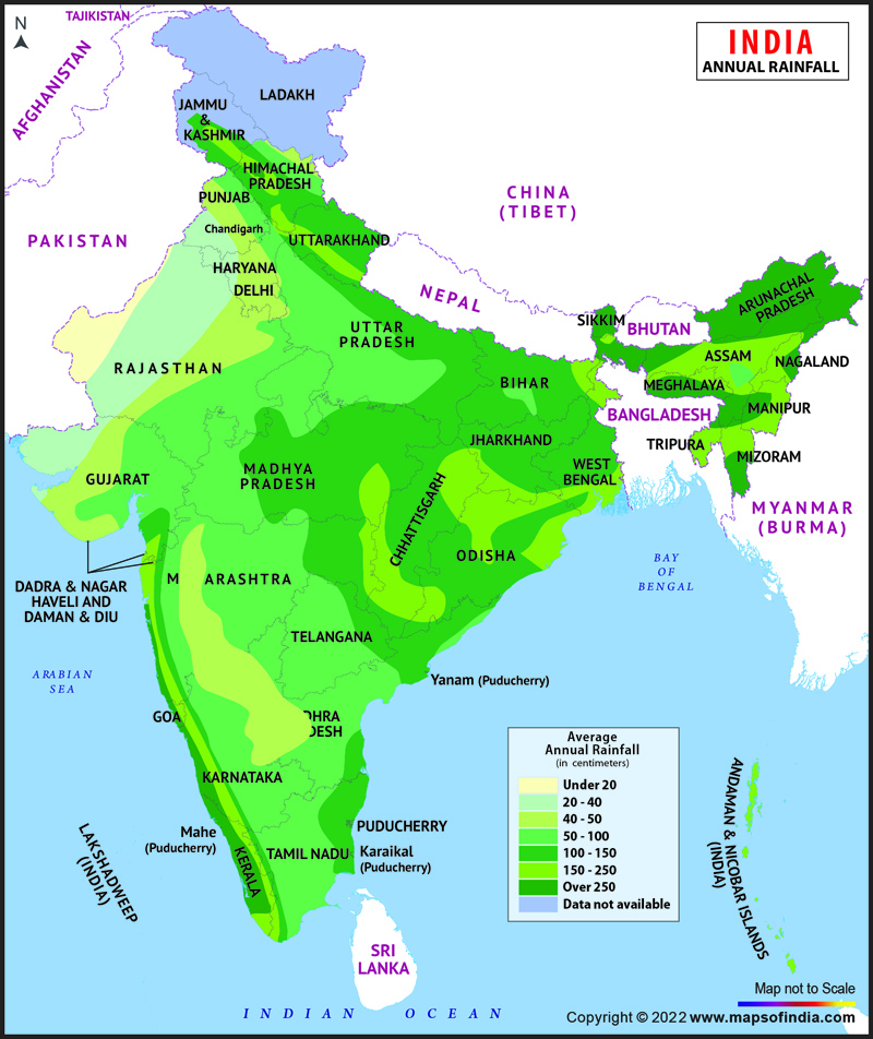
Source: India Map — Annual Rainfall Map of India, Rainfall in India · www.mapsofindia.com
Trap: Thinking west gets more rain due to Arabian Sea proximity — Western Ghats block it
Confusion: Rajasthan's low rainfall due to rain shadow + distance, not just one factor
Statement 2: Tests precise understanding of east-west decrease in northern plains only
Southwest Monsoon Mechanism
Geography monsoon Bay of Bengal Arabian Sea
Southwest Monsoon: Mechanism & Branches
Southwest monsoon has two branches: Bay of Bengal and Arabian Sea
Bay of Bengal branch is more effective for northern plains rainfall
Monsoon driven by thermal contrast between land and sea during summer
Basic Mechanism
The southwest monsoon results from thermal contrast between the heated Indian landmass and cooler Indian Ocean during summer. This creates a low pressure system over land, drawing moisture-laden winds from the ocean.
Monsoon Development Process
%%{init: {"flowchart": {"wrappingWidth": 460}}}%%
flowchart TD
  s1["`**Summer Heating**
Indian landmass heats up, creating **thermal low pressure**`"]
  s2["`**Pressure Gradient**
**High pressure** over Indian Ocean, **low over land** — drives wind flow`"]
  s3["`**Wind Reversal**
Trade winds reverse direction, become **southwest monsoon winds**`"]
  s4["`**Moisture Pickup**
Winds pick up **maximum moisture** over warm Indian Ocean`"]
  s5["`**Landfall & Rainfall**
Moisture-laden winds hit land, forced upward, cause **orographic rainfall**`"]
  s1 --> s2
  s2 --> s3
  s3 --> s4
  s4 --> s5
Two Monsoon Branches Compared
Feature | Bay of Bengal Branch | Arabian Sea Branch |
|---|---|---|
Path | Bangladesh → Ganga valley → Northwest | Kerala → Western Ghats → Central India |
Moisture Content | Very high (open sea approach) | High but reduces after Western Ghats |
Coverage | Northern plains, Northeast India | Western coast, Central India |
Rainfall Pattern | Decreases west to east | Maximum on Western Ghats |
Key Impact | Main source for Ganga plains | Heavy rainfall on west coast |
Duration | June-September | June-September |
Trap: Confusing monsoon arrival pattern with withdrawal pattern — they're opposite
Common error: Thinking Arabian Sea branch is more important for northern plains
Key distinction: Bay of Bengal branch explains the east-west rainfall gradient
Indian Rainfall Patterns & Distribution
Geography annual rainfall
Indian Rainfall Distribution: Zones & Patterns
India has four rainfall zones: Very High (>200cm), High (100-200cm), Moderate (50-100cm), Low (<50cm)
Western Ghats, Northeast India get highest rainfall due to orographic effect
Rajasthan, parts of Gujarat form the lowest rainfall zone
Distribution Factors
Indian rainfall distribution is controlled by monsoon winds, topography, and distance from sea. The interaction between moisture-laden winds and mountain barriers creates distinct rainfall zones across the country.
Rainfall Zones of India
Zone | Annual Rainfall | Key Regions | Dominant Factor |
|---|---|---|---|
Very High | 200cm | Western Ghats, Northeast states, parts of West Bengal | Orographic + Monsoon |
High | 100-200cm | Eastern coast, Ganga plains (east), Sub-Himalayan region | Strong monsoon influence |
Moderate | 50-100cm | Deccan Plateau, Northern plains (west), Eastern coast | Moderate monsoon reach |
Low | <50cm | Western Rajasthan, parts of Gujarat, rain shadow areas | Rain shadow + distance |
Factors Controlling Rainfall
# Indian Rainfall Distribution
## Monsoon Intensity
- Bay of Bengal branch
- Arabian Sea branch
- Moisture content
- Wind direction
## Topographic Effect
- Western Ghats barrier
- Himalayas uplift
- Orographic rainfall
- Rain shadow zones
## Distance from Sea
- Coastal areas high
- Interior areas moderate
- Continental effect
- Moisture loss inland
## Seasonal Variations
- Southwest monsoon
- Northeast monsoon
- Pre-monsoon showers
- Winter rainfallTrap: Assuming coastal areas always get high rainfall — east coast varies significantly
Confusion: Cherrapunji vs Mawsynram — both in Meghalaya, both record high rainfall
Pattern error: Forgetting Tamil Nadu gets winter rainfall from northeast monsoon