With reference to the wetlands of India, consider the following statements: 1. The country's total geographical area under the category of wetlands is recorded more in Gujarat as compared to other States 2. In India, the total geographical area of coastal wetlands is larger than that of inland wetlands Which of the statements given above is/are correct?
Contents14
- A1 only
- B2 only
- CBoth 1 and 2
- DNeither 1 nor 2
Show answer
Answer: (A) 1 only
Statement 1 is correct —
Gujarat has the largest total wetland area in India, earning it the nickname 'Land of Wetlands.'
This is mainly due to the Gulf of Kutch, Gulf of Khambhat, and the Rann of Kutch.
Statement 2 is WRONG —
In India, inland wetlands cover a LARGER total area than coastal wetlands.
While India has a long coastline, its vast river floodplains, lakes, and marshes in the interior make inland wetlands more extensive overall.
Source: National Wetland Atlas.
Answer: 1 only.
Gujarat has the largest wetland area in India due to the Gulf of Kutch, Gulf of Khambhat, and the Rann of Kutch, earning it the nickname 'Land of Wetlands'.
Despite India's long coastline, inland wetlands like river floodplains and lakes cover more total area than coastal wetlands.
The question tests knowledge of wetland distribution patterns from the National Wetland Atlas, focusing on state-wise and type-wise coverage.
Gujarat's Wetland Dominance
Geography Gujarat wetlands
Gujarat: India's Largest Wetland State
Gujarat has the largest total wetland area in India
Known as 'Land of Wetlands' due to extensive coastal and salt marsh systems
Major wetlands include Gulf of Kutch, Gulf of Khambhat, and Rann of Kutch
Gujarat's wetland area exceeds other major wetland states like West Bengal and Uttar Pradesh
Gujarat leads India in total wetland coverage, earning the nickname 'Land of Wetlands'. This dominance stems from its unique geography — extensive coastline along the Arabian Sea creating major gulfs and the world's largest salt marsh in Kutch.
Gujarat's Major Wetland Systems
Wetland | Type | Location | Significance |
|---|---|---|---|
Gulf of Kutch | Marine National Park | Northwestern coast | India's first Marine National Park |
Gulf of Khambhat | Coastal wetland | Eastern coast | Major mudflats and tidal zones |
Rann of Kutch | Salt marsh | Kutch district | World's largest salt desert |
Thol Lake | Freshwater wetland | Mehsana district | Bird sanctuary, Ramsar site |
Gujarat Wetlands Map
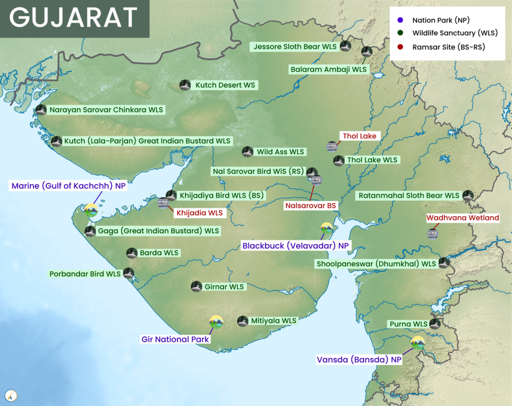
Source: LotusArise — Gujarat National Parks, Wildlife Sanctuaries & Ramsar Sites · lotusarise.com
Trap: Don't assume West Bengal has the most wetlands due to Sundarbans — Gujarat's total area is larger
Trap: Rann of Kutch is a wetland (salt marsh), not just a desert
Confusion: Gujarat has both coastal wetlands (gulfs) and inland wetlands (Rann, lakes)
Inland vs Coastal Wetlands Distribution
Geography inland wetlands coastal wetlands geographical area
India's Wetland Distribution: Inland Dominates Coastal
Inland wetlands cover larger total area than coastal wetlands in India
River floodplains, lakes, and marshes make up the bulk of inland wetlands
Despite 7,500+ km coastline, coastal wetlands are smaller in total area
Data source: National Wetland Atlas by Space Applications Centre
Despite India's extensive 7,500+ km coastline, inland wetlands cover a larger total geographical area than coastal ones. The vast river systems, floodplains, and inland water bodies across the subcontinent create more wetland area than the coastal margins.
Wetland Types Comparison
Wetland Type | Examples | Major States | Area Coverage |
|---|---|---|---|
Inland Wetlands | River floodplains, lakes, marshes, reservoirs | UP, West Bengal, Gujarat, Rajasthan | Larger total area |
Coastal Wetlands | Estuaries, lagoons, mangroves, mudflats | Gujarat, West Bengal, Tamil Nadu, Andhra Pradesh | Smaller total area |
Why Inland Wetlands Dominate
Gangetic plains create vast floodplain wetlands across multiple states
Brahmaputra valley adds extensive wetland systems in Northeast
Thar Desert lakes and salt lakes in Rajasthan contribute significant area
Reservoir systems and man-made wetlands are predominantly inland
Coastal wetlands are linear along coastline vs extensive coverage of inland systems
India Wetland Distribution
Map of India showing distribution of inland wetlands (rivers, lakes, floodplains) versus coastal wetlands (estuaries, mangroves) with different colors
Inland wetlands (blue) cover more total area than coastal wetlands (green) despite India's long coastline
Trap: Long coastline ≠ larger coastal wetland area — inland systems are more extensive
Confusion: Don't equate number of coastal wetlands with total area coverage
Statement 2 trap: Coastal > Inland seems logical but is factually wrong
Indian Wetland Classification
Geography
Classification & Inventory of Indian Wetlands
India follows 2-tier classification: Natural vs Man-made wetlands
National Wetland Atlas by SAC provides comprehensive wetland mapping
India has 75+ Ramsar sites (internationally important wetlands)
Wetlands cover approximately 1.5% of India's geographical area
Wetland Classification
# Indian Wetlands
## Natural Wetlands
- Lakes
- Rivers/Streams
- Floodplains
- Swamps/Marshes
- Coastal wetlands
- High altitude wetlands
## Man-made Wetlands
- Reservoirs
- Tanks/Ponds
- Waterlogged areas
- Salt pans
- Aquaculture ponds
Key Wetland Categories
Category | Sub-types | Examples | Distribution |
|---|---|---|---|
Coastal | Estuaries, Lagoons, Mangroves | Chilika Lake, Sundarbans | Along 7,500+ km coastline |
Inland | Rivers, Lakes, Marshes | Dal Lake, Wular Lake | Across river basins |
High Altitude | Glacial lakes, Alpine wetlands | Tsomoriri, Pangong Tso | Himalayas, Ladakh |
Man-made | Reservoirs, Tanks | Kolleru Lake, Loktak Lake | Human-modified systems |
Wetland Inventory System
Space Applications Centre (SAC) conducts national wetland mapping using satellite data
National Wetland Atlas updated periodically — comprehensive state-wise data source
Ramsar Convention criteria used for identifying wetlands of international importance
Directory of Indian Wetlands lists over 27,000 wetlands across the country
State-wise Wetland Distribution
Geography
Top Wetland States in India by Area
Gujarat leads in total wetland area, followed by West Bengal and UP
West Bengal has highest density due to Sundarbans and Gangetic delta
Uttar Pradesh contributes through Gangetic floodplains and Terai region
Rajasthan significant due to desert lakes and salt lakes
Top Wetland States
State | Major Wetland Types | Key Examples | Ranking Factor |
|---|---|---|---|
Gujarat | Coastal + Salt marshes | Gulf of Kutch, Rann of Kutch | Largest total area |
West Bengal | Mangroves + Rivers | Sundarbans, East Kolkata | Highest density |
Uttar Pradesh | River floodplains | Gangetic wetlands, Terai lakes | Extensive river systems |
Rajasthan | Desert + Salt lakes | Sambhar Lake, Desert wetlands | Arid zone wetlands |
Tamil Nadu | Coastal + Inland | Pulicat Lake, Pichavaram | Long coastline |
Regional Wetland Patterns
Western states (Gujarat, Rajasthan) dominate due to coastal systems and salt lakes
Eastern states (West Bengal, Assam) rich in riverine and deltaic wetlands
Northern plains (UP, Bihar) contribute through Gangetic floodplain systems
Southern peninsular states have scattered coastal and inland wetland systems
Himalayan states have unique high-altitude wetland ecosystems
Trap: West Bengal seems obvious due to Sundarbans, but Gujarat has larger total area
Don't assume coastal states automatically have more wetlands than inland states
Rajasthan (desert state) is actually a major wetland contributor due to salt lakes