Consider the following pairs:
Contents16
Consider the following pairs:
| National Park | River flowing through the Park | |
|---|---|---|
| 1. | Corbett National Park | Ganga |
| 2. | Kaziranga National Park | Manas |
| 3. | Silent Valley National Park | Kaveri |
Which of the above pairs is/are correctly matched?
- A1 and 2
- B3 only
- C1 and 3
- DNone
Show answer
Answer: (D) None
None of the pairs is correctly matched:
Pair 1 — Corbett National Park is associated with the Ramganga river (a tributary of the Ganga), NOT the Ganga itself. The Ganga does not flow through Corbett.
Pair 2 — Kaziranga National Park lies in the floodplains of the Brahmaputra river, NOT the Manas river. The Manas river flows through Manas National Park (a separate national park in Assam).
Pair 3 — Silent Valley National Park in Kerala has the Kunthi river (Kunthipuzha) flowing through it, NOT the Kaveri. The Kaveri originates in Kodagu (Coorg) in Karnataka and flows through Tamil Nadu — nowhere near Silent Valley in the Palakkad district of Kerala.
So the answer is (d) — None of the pairs is correctly matched. This is a classic geography factual question testing map-based knowledge.
National parks and their rivers is a standard factual geography topic that requires precise map-based knowledge of India's protected areas and drainage systems.
UPSC uses deliberately confusing pairs where famous rivers are matched with famous parks, but not the correct ones - Corbett is linked with Ramganga not Ganga, Kaziranga with Brahmaputra not Manas, and Silent Valley with Kunthi river not Kaveri.
The question tests whether students can distinguish between geographically close but distinct features - like Manas river versus Manas National Park, or tributary relationships like Ramganga being part of Ganga system but not the main river.
Corbett National Park & Ramganga River
Geography Corbett National Park Ganga
Corbett National Park: Location, Rivers & Key Facts
Corbett National Park is in Uttarakhand, established in 1936 as India's first national park
Ramganga River flows through Corbett, NOT the Ganga itself
Famous for Bengal tigers and is part of Project Tiger since 1973
Located in Nainital district of Uttarakhand
River System
Corbett National Park sits along the Ramganga River, a major tributary of the Ganga. The Ramganga originates from the Garhwal hills and flows through the park, creating diverse habitats including grasslands, riverine belts, and marshy depressions.
Corbett Park Facts
Aspect | Details |
|---|---|
Established | 1936 (India's first national park) |
State | Uttarakhand |
River | Ramganga (tributary of Ganga) |
Famous For | Bengal Tigers, Asian elephants |
Area | Approximately 520 sq km |
Project Tiger | Since 1973 |
Location Map

Source: Jim Corbett National Park — Updated Map of Jim Corbett National Park- Ramganga NP-2024 · www.jimcorbettnationalpark.com
Trap: UPSC tests confusion between Ganga and Ramganga — Corbett has Ramganga, not Ganga
Common Error: Mixing up Corbett (Ramganga) with parks actually on the Ganga like Rajaji National Park
Memory Aid: Ram-ganga flows through Corbett — both have strong consonant sounds (R-C connection)
Kaziranga National Park & Brahmaputra
Geography Kaziranga National Park Manas
Kaziranga vs Manas: Two Different Parks in Assam
Kaziranga National Park lies in Brahmaputra floodplains, NOT Manas river
Manas National Park is a separate park where Manas River flows
Both parks are in Assam but have different river systems
Kaziranga is UNESCO World Heritage Site famous for one-horned rhinos
Kaziranga vs Manas Parks
Park | River System | Famous For | Status |
|---|---|---|---|
Kaziranga National Park | Brahmaputra River floodplains | One-horned rhinoceros | UNESCO World Heritage Site |
Manas National Park | Manas River (Brahmaputra tributary) | Project Tiger, biodiversity | UNESCO World Heritage Site |
River Geography
Kaziranga spreads across the Brahmaputra's floodplains in central Assam. The Manas River is a separate tributary that flows through Manas National Park in western Assam, near the Bhutan border.
Assam Parks Map
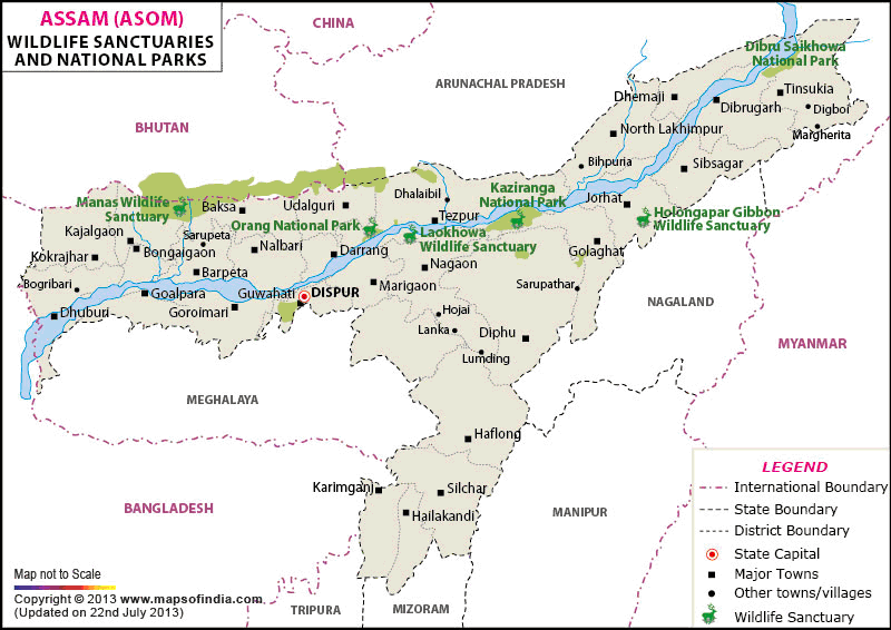
Source: India Map — Wildlife Sanctuaries in Assam, National parks of Assam · www.mapsofindia.com
Major Trap: UPSC swaps Kaziranga-Brahmaputra with Manas-Manas — these are two different parks
Memory Aid: Kazi-ranga sounds like Brahma-putra (both have 4 syllables)
Location Confusion: Both parks are in Assam but Kaziranga is central, Manas is western near Bhutan
Silent Valley & Kunthi River
Geography Silent Valley National Park Kaveri
Silent Valley National Park: Kerala's Western Ghats Gem
Silent Valley is in Kerala's Palakkad district, NOT connected to Kaveri river
Kunthi River (Kunthipuzha) flows through Silent Valley
Kaveri River originates in Karnataka and flows through Tamil Nadu — nowhere near Kerala
Part of Nilgiri Biosphere Reserve in Western Ghats
Geography & Rivers
Silent Valley National Park lies in Kerala's Western Ghats. The Kunthi River (also called Kunthipuzha) flows through the park, eventually joining the Bharathapuzha system that drains into the Arabian Sea.
Silent Valley vs Kaveri Geography
Feature | Silent Valley | Kaveri River |
|---|---|---|
Location | Kerala (Palakkad district) | Karnataka origin → Tamil Nadu |
River System | Kunthi River (Kunthipuzha) | Major river of South India |
Drainage | Arabian Sea (via Bharathapuzha) | Bay of Bengal |
Mountain Range | Western Ghats | Eastern Ghats in lower course |
South India Rivers Map
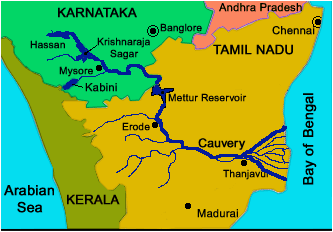
Source: Cauvery — Kaveri or Cauvery River in South India · www.cauvery.com
Silent Valley Significance
Tropical evergreen forest — one of the last undisturbed patches in Western Ghats
No cicadas — hence the name 'Silent' Valley (local belief, though scientifically debated)
Biodiversity hotspot — endemic species of plants and animals
Hydroelectric controversy — proposed dam was cancelled due to environmental concerns in 1980s
Geographic Trap: Kaveri is a Karnataka-Tamil Nadu river — completely different from Kerala's rivers
State Confusion: Silent Valley is Kerala, Kaveri is Karnataka origin — different South Indian states
Drainage Direction: Silent Valley drains to Arabian Sea, Kaveri drains to Bay of Bengal
Rivers Through Indian National Parks
Geography
Major Rivers Flowing Through Indian National Parks
Many national parks are strategically located along river systems for water availability
Floodplain parks like Kaziranga depend on seasonal flooding for grassland maintenance
UPSC frequently tests park-river associations in matching questions
Key Park-River Associations
National Park | State | River System | Key Feature |
|---|---|---|---|
Corbett | Uttarakhand | Ramganga | India's first national park |
Kaziranga | Assam | Brahmaputra floodplains | One-horned rhinos |
Manas | Assam | Manas River | Project Tiger site |
Sundarbans | West Bengal | Ganga delta | Royal Bengal tigers |
Keoladeo | Rajasthan | Gambhir-Banganga | Bird sanctuary |
Silent Valley | Kerala | Kunthi River | Western Ghats biodiversity |
River Systems & Parks
# Rivers in National Parks
## Ganga System
- Corbett (Ramganga)
- Rajaji (Ganga)
- Sundarbans (Ganga delta)
## Brahmaputra System
- Kaziranga (Brahmaputra)
- Manas (Manas tributary)
- Dibru-Saikhowa (Brahmaputra)
## Western Ghats
- Silent Valley (Kunthi)
- Periyar (Periyar)
- Bandipur (Kabini)
## Central India
- Kanha (Banjar)
- Pench (Pench)
- Satpura (Tawa)Common Mixing: Don't confuse Kaziranga-Brahmaputra with Manas-Manas (both in Assam)
Tributary Trap: Corbett has Ramganga (Ganga tributary), not Ganga directly
State Geography: Silent Valley is Kerala, Kaveri is Karnataka-Tamil Nadu system
Delta Confusion: Sundarbans is Ganga delta, Bhitarkanika is Mahanadi delta