A particular State in India has the following characteristics: 1. It is located on the same latitude which passes through northern Rajasthan 2. It has over 80% of its area under forest cover 3. Over 12% of forest cover constitutes Protected Area Network in this State. Which one among the following States has all the above characteristics?
Contents15
- AArunachal Pradesh
- BAssam
- CHimachal Pradesh
- DUttarakhand
Show answer
Answer: (A) Arunachal Pradesh
Arunachal Pradesh fits all three clues:
(1) It lies at approximately 27-29°N latitude — the same latitude that passes through northern Rajasthan (Jaisalmer, Bikaner area).
(2) It has over 80% forest cover — one of the highest in India (as per the Forest Survey of India reports).
(3) Over 12% of its forest area is under Protected Area Network (national parks + wildlife sanctuaries).
Assam has lower forest cover, Himachal Pradesh is at different latitudes, and Uttarakhand doesn't meet all three criteria simultaneously.
Answer: Arunachal Pradesh.
Arunachal Pradesh has over 80% forest cover, making it one of India's most forested states along with Mizoram and Manipur.
The latitude clue is key - northern Rajasthan (around Jaisalmer-Bikaner) lies at 27-29°N, the same latitude band as Arunachal Pradesh, while Himachal and Uttarakhand are at different latitudes.
UPSC is testing whether students can connect physical geography (latitude) with forest statistics and protected area data - not just memorize state facts in isolation.
Arunachal Pradesh Geography
Geography Arunachal Pradesh latitude forest cover Protected Area Network
Arunachal Pradesh: Location, Forest Cover & Protected Areas
Located at 27-29°N latitude — same as northern Rajasthan
Highest forest cover in India at over 80%
Over 12% of forest area under Protected Area Network
Capital: Itanagar; borders China, Myanmar, Bhutan
Why This Matters
Arunachal Pradesh is India's most forested state and a biodiversity hotspot in the Eastern Himalayas. Its unique latitude position connects it geographically with Rajasthan's northern districts, making it a favorite UPSC trap question.
Key Geographic Facts
Parameter | Arunachal Pradesh | National Average |
|---|---|---|
Latitude Range | 27°N to 29°N | 8°N to 37°N |
Forest Cover | >80% | 21.7% |
Protected Area Network | >12% of forest area | ~5% of total area |
Borders | China, Myanmar, Bhutan | Various |
Location Map
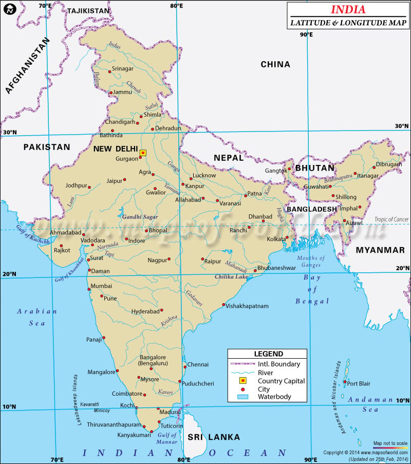
Source: World Map — India Latitude and Longitude Map · www.mapsofworld.com
Forest & Biodiversity
Part of Indo-Burma biodiversity hotspot — global conservation priority
Home to Namdapha National Park — only park with four big cats
Pakke Tiger Reserve and Eaglenest Wildlife Sanctuary are key protected areas
Dense tropical and subtropical forests due to high rainfall from monsoons
Trap: Confusing Arunachal Pradesh with Assam — Assam has lower forest cover
Trap: Thinking Himachal Pradesh fits — it's at different latitude (30-33°N)
Trap: Uttarakhand seems forested but doesn't meet all three criteria simultaneously
Remember: 27-29°N latitude is the key geographic clue that eliminates other options
Forest Cover by Indian States
Geography forest cover 80%
State-wise Forest Cover: Rankings & UPSC Facts
Arunachal Pradesh has highest forest cover percentage (>80%)
Madhya Pradesh has largest forest area by total size
Forest Survey of India releases biennial forest cover reports
Top Forest Cover States
State | Forest Cover % | Key Feature | UPSC Relevance |
|---|---|---|---|
Arunachal Pradesh | 80% | Highest percentage | Biodiversity hotspot |
Mizoram | ~85% | High percentage | Jhum cultivation issues |
Nagaland | ~75% | Northeastern pattern | Tribal forest rights |
Meghalaya | ~76% | High rainfall region | Sacred groves |
Manipur | ~77% | Loktak Lake region | Floating islands |
Why Northeast Dominates
High rainfall from southwest and northeast monsoons creates dense forests
Mountainous terrain with limited agriculture allows forest preservation
Tribal communities have traditional forest conservation practices
Lower population density reduces deforestation pressure compared to plains
Don't confuse forest cover percentage with total forest area — MP leads in area, AP in percentage
Assam has significant forest but much lower percentage due to agriculture and tea gardens
Western Ghats states like Karnataka have good forest cover but not >80%
Protected Area Network in India
Geography Protected Area Network 12%
Protected Area Network: Classification & State Performance
India has 5% of total area under Protected Area Network
National Parks + Wildlife Sanctuaries + Conservation Reserves + Community Reserves
Arunachal Pradesh has >12% of forest area as protected
Protected Area Types
# Protected Area Network
## National Parks
- No human activity
- Supreme protection
- 104 total in India
## Wildlife Sanctuaries
- Limited human activity
- 565+ total
- Grazing may be allowed
## Conservation Reserves
- Buffer zones
- Community participation
- Mixed ownership
## Community Reserves
- Community managed
- Private/community land
- Local conservation
State-wise Protected Area Performance
State | % of State Area Protected | Key Protected Areas | Specialty |
|---|---|---|---|
Arunachal Pradesh | 12% of forest | Namdapha NP | Four big cats |
Assam | ~7% | Kaziranga NP | One-horned rhino |
Himachal Pradesh | ~6% | Great Himalayan NP | Alpine biodiversity |
Uttarakhand | ~13% | Jim Corbett NP | First national park |
Protected Area Network includes all four categories — not just National Parks
Percentage can be calculated as % of state area OR % of forest area — read question carefully
Arunachal Pradesh leads in forest area protection, Uttarakhand in total area protection
Important Latitude Lines in India
Geography latitude northern Rajasthan
Key Latitude Lines: Tropic of Cancer & Regional Markers
Tropic of Cancer (23.5°N) passes through 8 Indian states
27-28°N connects northern Rajasthan with Arunachal Pradesh
India extends from 8°4'N to 37°6'N latitude
Key Latitude References
Latitude | Passes Through | UPSC Significance |
|---|---|---|
8°4'N | Kanyakumari (southernmost) | India's southern extent |
23.5°N | Tropic of Cancer - 8 states | Tropical/subtropical divide |
27-29°N | N. Rajasthan, Arunachal Pradesh | Question connector |
37°6'N | Indira Col, Ladakh | Northernmost point |
Tropic of Cancer States
Gujarat (Ahmedabad lies close to Tropic of Cancer)
Rajasthan (passes through Banswara district)
Madhya Pradesh (Jabalpur is on the line)
Chhattisgarh, Jharkhand, West Bengal (passes through central regions)
Tripura, Mizoram (northeastern states on the line)
Latitude Map
Map of India showing major latitude lines including Tropic of Cancer at 23.5°N and 27-28°N line passing through northern Rajasthan and Arunachal Pradesh
27-28°N latitude creates the geographic link between Rajasthan and Arunachal Pradesh
Don't confuse Tropic of Cancer (23.5°N) with the 27-28°N line mentioned in this question
Northern Rajasthan refers to districts like Bikaner, Jaisalmer — not the Tropic of Cancer line
Latitude determines climate zones — same latitude means similar seasonal patterns despite different geography