Consider the following: 1. Electromagnetic radiation 2. Geothermal energy 3. Gravitational force 4. Plate movements 5. Rotation of the earth 6. Revolution of the earth Which of the above are responsible for bringing dynamic changes on the surface of the earth?
Contents21
- A1, 2, 3 and 4 only
- B1, 3, 5 and 6 only
- C2, 4, 5 and 6 only
- D1, 2, 3, 4, 5 and 6
Show answer
Answer: (D) 1, 2, 3, 4, 5 and 6
All six forces contribute to dynamic changes on Earth's surface.
Here's how each one works:
(1) Electromagnetic radiation (solar energy) — drives weathering, evaporation, wind, and water cycles. It also causes temperature changes that induce metamorphism of rocks.
(2) Geothermal energy — the heat from Earth's interior is the main force behind endogenic (internal) processes like volcanism and earthquakes.
(3) Gravitational force — besides being a directional force activating all downslope movements (landslides, river flow), it also causes stresses on the Earth's materials.
(4) Plate movements — result in continent building, mountain formation, earthquakes, and volcanic activity.
(5) Rotation of the earth — generates the Coriolis effect affecting wind and ocean currents, and contributes to tidal friction.
(6) Revolution of the earth — contributes to seasonal changes that affect weathering, erosion, and biological processes on the surface.
So all six are responsible for dynamic surface changes.
Earth's surface changes result from both external forces like solar energy and internal forces like geothermal heat, making this a fundamental concept connecting physical geography topics.
Students often miss that astronomical forces like Earth's rotation and revolution also cause surface changes through effects like Coriolis force on winds and seasonal weathering cycles.
The question tests whether students can distinguish between forces that directly change the surface versus those that only influence other processes.
Electromagnetic Radiation & Surface Changes
Geography Electromagnetic radiation solar energy
Electromagnetic Radiation: Solar Energy Driving Earth's Surface Changes
Solar electromagnetic radiation drives most exogenic processes on Earth's surface
Powers weathering, evaporation, wind systems and the entire water cycle
Creates temperature variations that cause rock expansion/contraction and metamorphism
Primary energy source for atmospheric and oceanic circulation
Solar electromagnetic radiation is the fundamental external energy source that powers most surface processes on Earth. Without this energy input, our planet would be a frozen, geologically inactive world.
How Solar Energy Drives Surface Changes
Process Category | Mechanism | Surface Impact | Examples |
|---|---|---|---|
Physical Weathering | Thermal expansion/contraction | Rock breakdown | Freeze-thaw cycles, thermal stress |
Chemical Weathering | Temperature-dependent reactions | Rock decomposition | Oxidation, hydrolysis, carbonation |
Water Cycle | Evaporation & precipitation | Erosion & deposition | Rivers, glaciers, coastal processes |
Atmospheric Circulation | Differential heating | Wind erosion & transport | Dust storms, coastal erosion |
Metamorphism | Heat-induced mineral changes | Rock transformation | Contact metamorphism near surface |
Key Mechanisms
Differential heating between equator and poles drives global wind and ocean current systems
Diurnal temperature cycles cause rocks to expand and contract, leading to mechanical fracturing
Seasonal variations control the intensity of weathering and biological activity
Photosynthesis powered by solar energy affects chemical weathering through organic acid production
Evaporation transfers water from oceans to atmosphere, enabling precipitation and erosional processes
Trap: Students may think electromagnetic radiation only means visible light — it includes the entire solar spectrum
Trap: Don't confuse with geothermal energy — solar radiation is external, geothermal is internal
Trap: Solar energy doesn't directly cause earthquakes or volcanism — those are driven by internal forces
Geothermal Energy & Endogenic Processes
Geography Geothermal energy
Geothermal Energy: Earth's Internal Heat Engine
Geothermal energy from Earth's interior drives all endogenic processes
Primary force behind volcanism, earthquakes and plate movements
Creates convection currents in the mantle that drive plate tectonics
Heat sources include radioactive decay and primordial heat from Earth's formation
Geothermal energy is Earth's internal heat that powers all endogenic (internal) geological processes. This heat engine has been operating for billions of years, constantly reshaping the planet's surface from below.
How Geothermal Energy Creates Surface Changes
%%{init: {"flowchart": {"wrappingWidth": 460}}}%%
flowchart TD
  s1["`**Heat Generation**
**Radioactive decay** in core/mantle + **primordial heat** from planetary formation`"]
  s2["`**Mantle Convection**
Rising hot material and sinking cool material create **convection currents**`"]
  s3["`**Plate Movement**
Convection currents drive **lithospheric plates** to move, collide, separate`"]
  s4["`**Surface Manifestation**
**Earthquakes, volcanism, mountain building, rift formation** occur at plate boundaries`"]
  s1 --> s2
  s2 --> s3
  s3 --> s4
Geothermal-Driven Surface Features
Process | Mechanism | Surface Result | Examples |
|---|---|---|---|
Volcanism | Magma rises due to heat/pressure | Volcanic mountains, lava flows | Ring of Fire volcanoes, hotspot chains |
Earthquakes | Stress release from plate motion | Ground shaking, surface ruptures | San Andreas Fault, Himalayan seismic zone |
Mountain Building | Plate collision & compression | Fold mountains, thrust belts | Himalayas, Andes, Alps |
Rifting | Plate separation & extension | Rift valleys, new ocean basins | East African Rift, Mid-Atlantic Ridge |
Metamorphism | Heat & pressure transformation | Changed rock composition | Regional metamorphic belts |
Trap: Geothermal energy creates endogenic changes — don't confuse with exogenic processes like weathering
Trap: All plate movements are ultimately powered by geothermal energy, not just volcanism
Trap: Geothermal energy works on geological timescales — effects may take millions of years to manifest
Gravitational Force & Mass Movement
Geography Gravitational force
Gravitational Force: The Universal Driver of Downslope Movement
Gravity drives all downslope mass movements and water flow on Earth's surface
Powers rivers, glaciers, landslides and all erosional transport
Creates tidal forces that cause coastal changes and internal friction
Causes isostatic adjustment as surface loads change over time
Gravitational force is the fundamental force that pulls all matter toward Earth's center. This constant downward pull is essential for moving weathered material, water, and ice across the surface, making gravity a key agent of landscape change.
Gravity-Driven Surface Processes
# Gravitational Force
## Mass Wasting
- Landslides
- Rockfalls
- Debris flows
- Soil creep
## Water Flow
- River systems
- Groundwater flow
- Waterfall erosion
- Valley cutting
## Ice Movement
- Glacier flow
- Ice sheet motion
- Glacial erosion
- Moraine transport
## Tidal Effects
- Coastal erosion
- Tidal friction
- Sediment transport
- Estuary dynamics
## Isostatic Processes
- Post-glacial rebound
- Volcanic loading
- Sediment loading
- Crustal adjustment
Key Gravitational Mechanisms
Slope gradient determines the rate and type of gravitational mass movement
Tidal forces from Moon and Sun create twice-daily stress cycles on coastal areas
Isostatic equilibrium causes land to rise or sink as surface loads (ice sheets, sediments) change
Potential energy converts to kinetic energy as materials move from high to low elevations
Base level (usually sea level) provides the ultimate destination for gravity-driven transport
Trap: Gravity doesn't just cause landslides — it drives all downslope movement including rivers and glaciers
Trap: Tidal forces are gravitational effects that create surface changes beyond just ocean tides
Trap: Isostatic adjustment is a slow gravitational response often overlooked in surface change discussions
Plate Movements & Tectonic Processes
Geography Plate movements
Plate Movements: The Primary Architect of Earth's Surface
Plate tectonics is the unifying theory explaining most large-scale surface features
Creates mountains, ocean basins, earthquakes and volcanic activity at plate boundaries
Three boundary types: divergent, convergent, transform — each creates distinct landforms
Plates move at 2-10 cm per year — slow but geologically significant over millions of years
Plate movements represent the most fundamental process shaping Earth's surface over geological time. The lithosphere is broken into rigid plates that move due to mantle convection, creating and destroying surface features at their boundaries.
Plate Boundary Types & Surface Features
Boundary Type | Plate Motion | Major Landforms | Geological Activity | Examples |
|---|---|---|---|---|
Divergent | Plates moving apart | Mid-ocean ridges, rift valleys | Seafloor spreading, volcanism | Mid-Atlantic Ridge, East African Rift |
Convergent (O-O) | Ocean-Ocean collision | Island arcs, trenches | Subduction, earthquakes, volcanism | Japan, Philippines, Aleutians |
Convergent (O-C) | Ocean-Continent collision | Coastal mountains, trenches | Subduction, volcanism, earthquakes | Andes, Cascades, Peru-Chile Trench |
Convergent (C-C) | Continent-Continent collision | Fold mountains, plateaus | Crustal thickening, earthquakes | Himalayas, Alps, Zagros |
Transform | Plates sliding past | Linear valleys, offset features | Strike-slip earthquakes | San Andreas, Alpine Fault |
Wilson Cycle: Plate Movement Through Time
%%{init: {"flowchart": {"wrappingWidth": 460}}}%%
flowchart TD
  s1["`**Rifting Stage**
Continental crust begins to **stretch and thin**, forming rift valleys`"]
  s2["`**Spreading Stage**
New **oceanic crust forms**, creating a narrow sea (like Red Sea today)`"]
  s3["`**Mature Ocean**
Wide ocean basin develops with **mid-ocean ridge** (like Atlantic Ocean)`"]
  s4["`**Subduction Begins**
Ocean floor starts **sinking** beneath continental margins`"]
  s5["`**Ocean Closure**
Continents approach each other as ocean **shrinks** (like Mediterranean today)`"]
  s6["`**Continental Collision**
**Mountain building** occurs as continents collide (like Himalayas)`"]
  s1 --> s2
  s2 --> s3
  s3 --> s4
  s4 --> s5
  s5 --> s6
Global Plate Boundaries
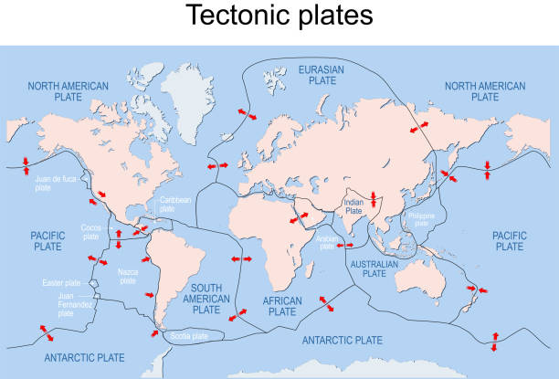
Source: iStock — 1,200+ Tectonic Plates Stock Illustrations, Royalty-Free Vector ... · www.istockphoto.com
Trap: Plate movements create features at boundaries, not just within plate interiors
Trap: All three boundary types actively change the surface — not just convergent boundaries
Trap: Plate tectonics explains both constructive (mountain building) and destructive (subduction) processes
Trap: Transform boundaries cause earthquakes but limited vertical surface changes
Earth's Rotation & Surface Dynamics
Geography Rotation of the earth
Earth's Rotation: Spinning Effects on Surface Processes
Earth's rotation creates the Coriolis effect that deflects moving air and water
Controls global wind patterns and ocean current circulation
Tidal friction from rotation gradually slows Earth and affects crustal stress
Day-night cycles drive temperature variations affecting weathering rates
Earth's rotation creates several effects that significantly influence surface processes. The most important is the Coriolis effect, which deflects moving objects and drives global circulation patterns that reshape the surface through erosion and deposition.
Rotational Effects on Surface Systems
Effect | Mechanism | Surface Impact | Geographic Examples |
|---|---|---|---|
Coriolis Effect | Deflection of moving air/water | Wind patterns, ocean currents | Trade winds, westerlies, Gulf Stream |
Atmospheric Circulation | Pressure belts & wind systems | Desert formation, rainfall patterns | Sahara (subtropical high), monsoons |
Ocean Currents | Wind-driven + Coriolis deflection | Coastal erosion, sediment transport | Kuroshio Current, California Current |
Tidal Friction | Moon's gravity + Earth's rotation | Tidal bore erosion, estuary changes | Bay of Fundy, Amazon tidal bore |
Diurnal Temperature | Day-night heating cycles | Thermal weathering, frost action | Desert rock breakdown, freeze-thaw |
Key Rotational Mechanisms
Coriolis deflection is strongest at poles, zero at equator — affects global circulation intensity
Geostrophic balance between pressure gradient and Coriolis force creates stable wind patterns
Ekman spiral in oceans causes surface currents to flow at angles to wind direction
Tidal bulges drag behind Moon's position due to friction, gradually slowing Earth's rotation
Rotational velocity varies by latitude: 1,670 km/hr at equator, zero at poles
How Rotation Drives Global Circulation
%%{init: {"flowchart": {"wrappingWidth": 460}}}%%
flowchart TD
  s1["`**Solar Heating**
**Differential heating** creates pressure differences between equator and poles`"]
  s2["`**Air Movement Begins**
Air starts moving from **high pressure** (poles) to **low pressure** (equator)`"]
  s3["`**Coriolis Deflection**
**Earth's rotation** deflects moving air to the **right (Northern Hemisphere)** or **left (Southern Hemisphere)**`"]
  s4["`**Wind Belt Formation**
Deflection creates **trade winds, westerlies** and **polar easterlies**`"]
  s5["`**Surface Erosion**
Persistent wind patterns cause **dune formation, coastal erosion** and **sediment transport**`"]
  s1 --> s2
  s2 --> s3
  s3 --> s4
s4 --> s5Trap: Rotation affects moving fluids (air, water) more than solid surface features directly
Trap: Coriolis effect is zero at the equator — no deflection occurs there
Trap: Don't confuse rotation (24-hour spin) with revolution (365-day orbit around Sun)
Trap: Tidal friction is gradually slowing Earth's rotation — days are getting longer
Earth's Revolution & Seasonal Effects
Geography Revolution of the earth
Earth's Revolution: Orbital Controls on Surface Processes
Earth's revolution around Sun creates seasonal variations in temperature and weather
Axial tilt (23.5°) causes seasons that control weathering rates and biological activity
Milankovitch cycles in orbit shape long-term climate and ice age patterns
Perihelion/aphelion variations affect global energy budget and surface processes
Earth's revolution around the Sun, combined with its tilted axis, creates the seasonal cycle that drives many surface changes. These orbital variations control the intensity and duration of weathering, erosion, and biological processes throughout the year.
Revolutionary Effects on Surface Processes
Seasonal Process | Summer Effect | Winter Effect | Surface Change Result |
|---|---|---|---|
Chemical Weathering | High temperature = faster reactions | Low temperature = slower reactions | Variable rock breakdown rates |
Freeze-Thaw Cycles | Minimal in warm regions | Maximum in cold/temperate zones | Rock fracturing, soil formation |
Biological Activity | Peak plant growth & root action | Dormancy, reduced organic weathering | Seasonal soil development |
Glacial Processes | Ablation (melting) dominates | Accumulation (snowfall) dominates | Glacial advance/retreat cycles |
River Discharge | High (monsoon/snowmelt) | Low (frozen precipitation) | Seasonal erosion & deposition |
Wind Patterns | Monsoon reversal | Different pressure systems | Seasonal dust transport, dune migration |
Orbital Parameters Affecting Surface
# Earth's Revolution
## Axial Tilt (Obliquity)
- Currently 23.5°
- Varies 21.5°-24.5°
- Controls season intensity
- Affects ice sheet stability
## Orbital Eccentricity
- Currently nearly circular
- Varies over 100,000 years
- Controls perihelion distance
- Affects global climate
## Precession
- Wobble in Earth's axis
- 26,000-year cycle
- Changes timing of seasons
- Affects monsoon strength
## Seasonal Variations
- Temperature cycles
- Precipitation patterns
- Daylight duration
- Storm intensity
Key Revolutionary Controls
Solstices and equinoxes create maximum seasonal contrast in weathering and erosion rates
Monsoon systems are driven by seasonal heating differences between land and ocean
Perihelion occurs in January — Southern Hemisphere summer receives 6% more solar energy
Ice-albedo feedback amplifies seasonal effects in polar regions affecting global sea level
Milankovitch cycles control long-term ice age patterns that reshape entire continents
Trap: Revolution creates seasons, rotation creates day-night — don't swap these effects
Trap: Perihelion in January means Southern Hemisphere gets more intense seasons currently
Trap: Axial tilt, not distance from Sun, is the primary cause of seasons
Trap: Milankovitch cycles operate over thousands of years — much longer than weather patterns