Consider the following statements: 1. Jet streams occur in the Northern Hemisphere only. 2. Only some cyclones develop an eye. 3. The temperature inside the eye of a cyclone is nearly 10°C lesser than that of the surroundings. Which of the statements given above is/are correct?
Contents16
- A1 only
- B2 and 3 only
- C2 only
- D1 and 3 only
Show answer
Answer: (C) 2 only
Statement 1 (Jet streams only in Northern Hemisphere) — NOT CORRECT:
Jet streams occur in BOTH hemispheres.
They are fast-moving bands of air in the upper atmosphere created by the interaction of warm and cold air masses, pressure systems, and Earth's rotation.
Statement 2 (Only some cyclones develop an eye) — CORRECT:
Not all cyclones have an eye.
An eye typically forms only when the maximum sustained wind speeds exceed 74 mph (119 km/h).
The eye is the calm center of the storm, usually 20-40 miles across, with light winds and often clear skies.
Statement 3 (Temperature inside eye is 10°C less than surroundings) — NOT CORRECT:
This is the opposite!
The eye is WARMER, not cooler, than its surroundings.
At high altitudes (around 12 km), the eye can be 10°C WARMER than the surrounding environment.
At the surface, it's only slightly warmer (0-2°C).
The eye has the lowest surface pressure and the warmest temperatures aloft.
Answer: C (2 only).
Key Takeaway:
Jet streams = both hemispheres.
Only STRONG cyclones get an eye (winds > 74 mph).
The eye is WARMER than surroundings (not cooler).
These are common UPSC traps.
Only intense cyclones with sustained winds exceeding 74 mph develop an eye - weaker cyclonic systems remain eyeless throughout their lifecycle.
The eye of a cyclone is actually warmer than its surroundings by up to 10°C at high altitudes, not cooler as many students incorrectly assume.
UPSC tests precise understanding of cyclone structure and jet stream distribution to separate students who memorize from those who understand atmospheric dynamics.
Jet Streams: Global Distribution
Geography Jet streams Northern Hemisphere
Jet Streams: Formation & Global Distribution
Jet streams exist in both hemispheres — Northern and Southern
Form at 9-16 km altitude where warm and cold air masses meet
Wind speeds typically 120-250 km/h, can exceed 400 km/h
Polar Front Jet (60°N/S) and Subtropical Jet (30°N/S) are the major ones
What Are Jet Streams
Jet streams are fast-moving bands of air in the upper atmosphere (tropopause level). They form due to temperature differences between air masses, pressure gradients, and the Coriolis effect from Earth's rotation.
Flow generally west to east in both hemispheres
Act like rivers of air that steer weather systems
Strongest in winter when temperature contrasts are maximum
Major Jet Streams by Hemisphere
Jet Stream | Location | Altitude | Typical Speed | Season Strength |
|---|---|---|---|---|
Polar Front Jet (Northern) | 50-60°N | 9-12 km | 120-250 km/h | Stronger in winter |
Subtropical Jet (Northern) | 25-35°N | 12-16 km | 80-140 km/h | Year-round, peaks winter |
Polar Front Jet (Southern) | 50-60°S | 9-12 km | 120-250 km/h | Stronger in winter |
Subtropical Jet (Southern) | 25-35°S | 12-16 km | 80-140 km/h | Year-round, peaks winter |
Global Jet Stream Pattern
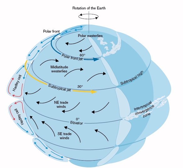
Source: Satellite Applications for Geoscience Education — Satellite Applications for Geoscience Education · cimss.ssec.wisc.edu
Statement 1 trap: Jet streams are NOT Northern Hemisphere only — they exist in both hemispheres
Don't confuse jet streams with trade winds (surface level) or westerlies (mid-latitude surface winds)
Seasonal variation: Northern jets are stronger in winter, but Southern hemisphere jets exist year-round too
Altitude confusion: Jet streams are in upper atmosphere (9-16 km), not at surface level
Cyclone Eye Formation
Geography cyclones eye
Cyclone Eye: Formation Conditions & Structure
Only strong cyclones develop an eye — needs sustained winds >119 km/h (74 mph)
Eye is 20-40 km across with calm winds and often clear skies
Weaker cyclones and depressions do NOT form an eye
Eye wall surrounds the eye with the strongest winds and heaviest rain
Why Only Some Cyclones Have Eyes
Not all cyclonic systems develop an eye. The eye forms only when the system reaches hurricane/typhoon intensity with sustained winds exceeding 119 km/h. Weaker systems like tropical depressions and tropical storms lack the organized circulation needed for eye formation.
Cyclone Classification & Eye Formation
Category | Wind Speed | Eye Present? | Characteristics |
|---|---|---|---|
Tropical Depression | <63 km/h | No | Weak circulation, no eye |
Tropical Storm | 63-118 km/h | No | Organized but no eye yet |
Hurricane/Typhoon | 119 km/h | Yes | Clear eye, strong eye wall |
Major Hurricane | 178 km/h | Yes | Well-defined eye, intense eye wall |
Cyclone Eye Structure
# Cyclone Eye
## Physical Features
- 20-40 km diameter
- Calm winds <15 km/h
- Often clear skies
- Lowest pressure center
## Formation Requirements
- Winds >119 km/h
- Strong circulation
- Low wind shear
- Warm ocean water
## Surrounding Elements
- Eye wall with strongest winds
- Rain bands spiral outward
- Maximum storm surge
- Heaviest precipitationStatement 2 is CORRECT: Only some (strong) cyclones develop an eye, not all cyclonic systems
Don't assume all low pressure systems have an eye — most depressions and storms don't
Eye ≠ cyclone center: Even without an eye, cyclones have a center of circulation
Eye formation needs time: Even strong cyclones may temporarily lose their eye during weakening
Cyclone Eye Temperature Profile
Geography temperature eye of a cyclone 10°C
Temperature Inside Cyclone Eye: Warming Not Cooling
Cyclone eye is WARMER than surroundings, not cooler
At 12 km altitude, eye can be 10°C warmer than environment
At surface level, eye is only 0-2°C warmer
Warming caused by subsiding air and adiabatic compression
Why the Eye is Warmer
The cyclone eye experiences subsidence — air sinks from high altitudes toward the surface. As air descends, it gets compressed and warms up through adiabatic warming. This makes the eye the warmest part of the entire cyclone system.
Temperature Profile: Eye vs Surroundings
Altitude Level | Eye Temperature | Surrounding Temperature | Difference | Cause |
|---|---|---|---|---|
Surface (0-1 km) | Slightly warmer | Baseline | +0 to +2°C | Minimal subsidence effect |
Mid-level (3-6 km) | Warmer | Cooler | +3 to +6°C | Moderate subsidence |
Upper level (12 km) | Much warmer | Much cooler | +8 to +12°C | Strong subsidence & compression |
Tropopause (15+ km) | Warmest | Coldest | +10 to +15°C | Maximum adiabatic warming |
Eye Warming Mechanism
%%{init: {"flowchart": {"wrappingWidth": 460}}}%%
flowchart TD
  s1["`**Air rises in eye wall**
Strong convection lifts air to high altitudes`"]
  s2["`**Air spreads outward at top**
Divergence occurs at upper levels (12-15 km)`"]
  s3["`**Air descends in eye center**
Subsidence brings air down from high altitude`"]
  s4["`**Descending air compresses**
Atmospheric pressure increases air density`"]
  s5["`**Compression causes warming**
Adiabatic warming heats the air mass`"]
  s6["`**Eye becomes warmest zone**
Continuous subsidence maintains warm core`"]
  s1 --> s2
  s2 --> s3
  s3 --> s4
  s4 --> s5
s5 --> s6Statement 3 trap: Eye is 10°C WARMER (not cooler) than surroundings at high altitude
Surface vs altitude confusion: Eye is only slightly warmer at surface but much warmer aloft
Don't confuse surface pressure (lowest in eye) with temperature (highest in eye at altitude)
Adiabatic warming in eye vs adiabatic cooling in rising air of eye wall — opposite processes
Tropical Cyclone Structure
Geography
Complete Structure of Tropical Cyclones
Three main parts: Eye (center), Eye wall (strongest winds), Rain bands (spiral arms)
Eye wall has the most destructive winds and heaviest rainfall
Rain bands extend 100-300 km from center with intermittent heavy rain
Warm core structure distinguishes tropical from extra-tropical cyclones
Cyclone Components
# Tropical Cyclone
## Eye (Center)
- 20-40 km wide
- Calm winds <15 km/h
- Clear/partly cloudy
- Lowest pressure
- Warmest temperatures
## Eye Wall
- Surrounds the eye
- Strongest winds 150-300 km/h
- Heaviest rainfall
- Towering cumulonimbus
- Most destructive zone
## Rain Bands
- Spiral arms outward
- Extend 100-300 km
- Intermittent heavy rain
- Embedded tornadoes
- Feeder bands
## Outer Circulation
- Light to moderate rain
- Increasing wind speeds
- Cloud cover thickens
- Pressure drops gradually
Cyclone Cross-Section
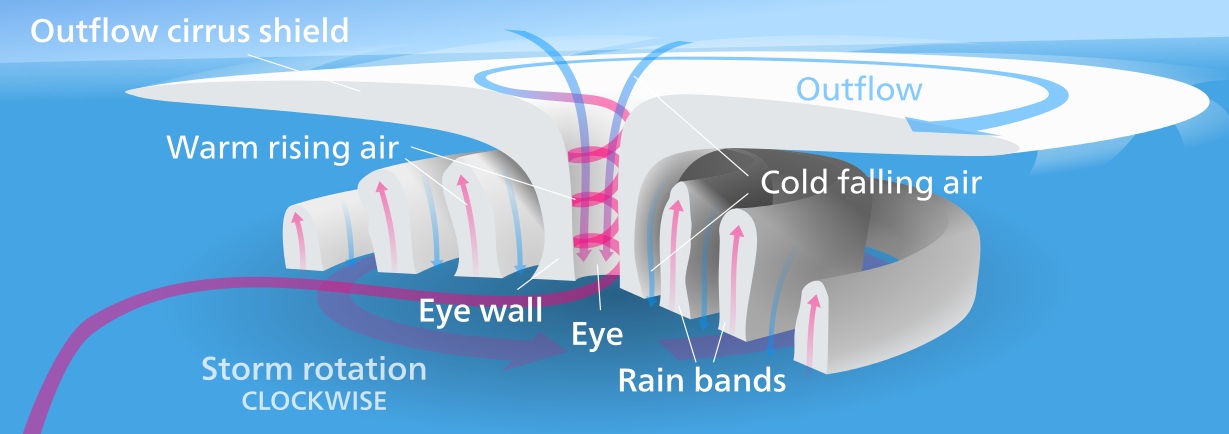
Source: BYJU'S — NCERT Notes on Tropical Cyclones · byjus.com
Cyclone Zones: Wind & Weather
Zone | Distance from Center | Wind Speed | Weather | Hazards |
|---|---|---|---|---|
Eye | 0-20 km | <15 km/h | Calm, often clear | False sense of security |
Eye Wall | 20-40 km | 150-300 km/h | Torrential rain | Most dangerous winds |
Inner Rain Bands | 40-100 km | 100-150 km/h | Heavy showers | Tornadoes possible |
Outer Rain Bands | 100-300 km | 50-100 km/h | Intermittent rain | Flooding, storm surge |
Outer Circulation | 300-500 km | 15-50 km/h | Light rain | Minimal direct damage |