What could be the main reason/reasons of the formation of African and Eurasian desert belt? 1. It is located in the sub-tropical high pressure cells. 2. It is under the influence of warm ocean currents. Which of the statements given above is/are correct in this context?
Contents20
- A1 only
- B2 only
- CBoth 1 and 2
- DNeither 1 nor 2
Show answer
Answer: (A) 1 only
Statement 1 is CORRECT:
The African-Eurasian desert belt (Sahara, Arabian, Thar, etc.) lies in the SUBTROPICAL HIGH-PRESSURE ZONE (around 20°-30° N latitude).
In this zone, air descends from high altitudes → descending air gets compressed and heated → it can hold more moisture instead of releasing it → NO rainfall → desert formation.
This is called the 'Hadley Cell' mechanism.
Statement 2 is WRONG:
WARM ocean currents actually bring MOISTURE and rainfall to nearby coasts (e.g., Gulf Stream warms Western Europe).
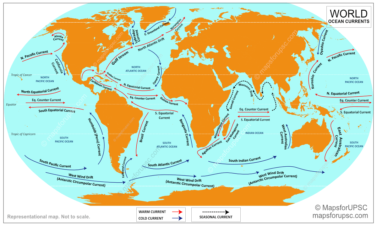
It's COLD ocean currents (like Canary Current off Sahara, Benguela Current off Namib Desert) that cause coastal deserts by cooling the air and preventing evaporation.
So warm currents are the OPPOSITE of what causes deserts.
Key concept:
- Subtropical deserts = high pressure (descending dry air).
- Coastal deserts = cold ocean currents.
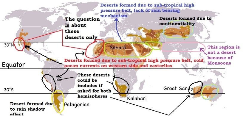
The African-Eurasian desert belt (Sahara, Arabian, Thar deserts) forms due to the subtropical high-pressure zone around 20°-30° N latitude where descending air gets compressed, heated, and cannot release moisture.
Warm ocean currents bring moisture and rainfall to coasts, while cold ocean currents like the Canary Current off Sahara actually create coastal deserts by cooling air and preventing evaporation.
Subtropical High Pressure Belt
Geography sub-tropical high pressure cells subtropical
Subtropical High Pressure Belt: Desert Formation Mechanism
Located at 20°-30° latitude in both hemispheres
Descending air creates high pressure and dry conditions
Forms world's major hot deserts: Sahara, Arabian, Thar, Kalahari
Part of Hadley Cell circulation pattern
Desert Formation Process
The subtropical high pressure belt is the primary reason for the world's major hot deserts. This zone experiences subsiding air from the upper atmosphere, which compresses and heats up as it descends, creating stable high-pressure conditions that prevent rainfall.
How High Pressure Creates Deserts
%%{init: {"flowchart": {"wrappingWidth": 460}}}%%
flowchart TD
  s1["`**Air rises at Equator**
Hot air ascends due to intense heating`"]
  s2["`**Air moves poleward**
Upper atmospheric air flows toward 30° latitude`"]
  s3["`**Air descends at 30°N/S**
Cool air sinks creating high pressure`"]
  s4["`**Adiabatic warming**
Descending air compresses and heats up`"]
  s5["`**Increased moisture capacity**
Warm air holds more water vapor, no precipitation`"]
  s6["`**Desert conditions**
Clear skies, low humidity, minimal rainfall`"]
  s1 --> s2
  s2 --> s3
  s3 --> s4
  s4 --> s5
  s5 --> s6
Major Subtropical Deserts
Desert | Location | Latitude | Continent |
|---|---|---|---|
Sahara | North Africa | 20°-30°N | Africa |
Arabian | Middle East | 20°-30°N | Asia |
Thar | India-Pakistan | 25°-30°N | Asia |
Kalahari | Southern Africa | 20°-30°S | Africa |
Atacama | Chile-Peru | 20°-30°S | South America |
Great Victoria | Australia | 25°-32°S | Australia |
Global Pressure Belts
Source: PMF IAS — Atmospheric Pressure Belts and Wind Systems - PMF IAS · www.pmfias.com
Trap: Confusing subtropical deserts (caused by high pressure) with coastal deserts (caused by cold currents)
Trap: Thinking warm ocean currents cause deserts - they actually bring moisture and rainfall
Trap: Forgetting the Hadley Cell mechanism - air must rise at equator and descend at 30° latitude
Ocean Currents & Climate Impact
Geography warm ocean currents
Ocean Currents: Warm vs Cold Climate Effects
Warm currents bring moisture and moderate temperatures to coasts
Cold currents create coastal deserts by cooling air masses
Statement 2 is WRONG - warm currents don't cause deserts
Examples: Gulf Stream (warm), Canary Current (cold)
Climate Impact Mechanism
Ocean currents significantly influence coastal climates through temperature regulation and moisture transport. The key distinction is that warm and cold currents have opposite effects on precipitation patterns and desert formation.
Warm vs Cold Ocean Currents
Factor | Warm Currents | Cold Currents |
|---|---|---|
Temperature Effect | Raise coastal temperatures | Lower coastal temperatures |
Evaporation | Increase evaporation | Reduce evaporation |
Moisture Content | Carry more water vapor | Carry less water vapor |
Precipitation | Increase rainfall | Decrease rainfall |
Climate Created | Humid, moderate | Arid, coastal deserts |
Example Current | Gulf Stream, Kuroshio | Canary, Benguela, Peru |
Coastal Effect | Western Europe warmth | Sahara, Namib, Atacama deserts |
Why Statement 2 is Wrong
Warm currents increase evaporation and bring more moisture to coastal areas
Examples: Gulf Stream makes Western Europe warmer and wetter than expected
Cold currents cool the air, reducing its moisture-holding capacity
Cold currents create coastal deserts: Canary Current → Sahara coast, Peru Current → Atacama Desert
Global Ocean Currents
Source: MapsforUPSC — Ocean Currents: Map, Types, Causes & Key Facts – UPSC · mapsforupsc.com
Trap: Assuming 'warm' ocean currents cause deserts - they actually prevent desert formation
Trap: Confusing coastal desert formation (cold currents) with interior desert formation (high pressure)
Trap: Not knowing specific examples - Canary Current causes Sahara's coastal aridity
African-Eurasian Desert Belt
Geography African and Eurasian desert belt
African-Eurasian Desert Belt: World's Largest Arid Zone
Largest continuous desert belt spanning Africa and Asia
Includes Sahara, Arabian, Thar and Iranian deserts
Located between 20°-30°N latitude in subtropical high pressure zone
Extends from Atlantic coast of Africa to Pakistan
Geographic Extent
The African-Eurasian desert belt forms the world's most extensive arid region, stretching approximately 12,000 km from Morocco's Atlantic coast to Pakistan's Thar Desert. This continuous belt demonstrates how subtropical high pressure creates consistent desert conditions across vast continental areas.
Major Deserts in the Belt
Desert | Country/Region | Area (approx.) | Key Features |
|---|---|---|---|
Sahara | North Africa | 9 million km² | World's largest hot desert |
Libyan Desert | Libya, Egypt | 1.1 million km² | Part of Sahara, extremely arid |
Arabian Desert | Saudi Arabia, UAE | 2.3 million km² | Rub' al Khali (Empty Quarter) |
Thar Desert | India, Pakistan | 200,000 km² | Great Indian Desert |
Dasht-e Kavir | Iran | 77,000 km² | Great Salt Desert |
Dasht-e Lut | Iran | 51,000 km² | Hottest surface temperatures recorded |
Formation Factors
# African-Eurasian Desert Belt
## Primary Cause
- Subtropical High Pressure
- Descending Air Masses
- 20°-30°N Latitude
## Geographic Factors
- Continental Interior
- Distance from Ocean
- Rain Shadow Effects
## Atmospheric Circulation
- Hadley Cell
- Trade Winds
- Anti-cyclonic Conditions
Desert Belt Map
Satellite or relief map showing the continuous African-Eurasian desert belt from Sahara through Arabian Peninsula to Thar Desert, with latitude lines marked
The continuous desert belt clearly shows the impact of subtropical high pressure across two continents
Trap: Thinking this belt is caused by distance from ocean - it's primarily atmospheric pressure
Trap: Confusing with cold current deserts like Namib or Atacama - those are coastal, not continental
Trap: Not recognizing the continuous nature - it's one connected climatic phenomenon, not separate deserts
Hadley Cell Circulation
Geography
Hadley Cell: The Engine Behind Subtropical Deserts
Thermal circulation between equator and 30° latitude
Creates ITCZ (rising air) and subtropical highs (descending air)
Drives trade winds and westerlies formation
Named after George Hadley (1735)
Circulation Mechanism
The Hadley Cell is Earth's most important atmospheric circulation pattern, driven by intense solar heating at the equator. This thermal circulation directly creates both the wet equatorial zone and the dry subtropical desert belt.
Complete Hadley Cell Process
%%{init: {"flowchart": {"wrappingWidth": 460}}}%%
flowchart TD
  s1["`**Equatorial Heating**
Intense solar radiation heats surface air`"]
  s2["`**Air Rises (ITCZ)**
Hot air becomes less dense and ascends`"]
  s3["`**Cooling & Condensation**
Rising air cools, water vapor condenses → heavy rainfall`"]
  s4["`**Poleward Flow**
Dry air moves toward 30° latitude at high altitude`"]
  s5["`**Air Descends at 30°**
Cool, dry air sinks creating high pressure`"]
  s6["`**Adiabatic Warming**
Descending air compresses and heats up`"]
  s7["`**Surface Return Flow**
Air flows back to equator as Trade Winds`"]
  s1 --> s2
  s2 --> s3
  s3 --> s4
  s4 --> s5
  s5 --> s6
  s6 --> s7
Hadley Cell Climate Zones
Latitude Zone | Air Movement | Pressure | Climate | Examples |
|---|---|---|---|---|
0°-10° | Rising (ITCZ) | Low pressure | Wet, tropical | Amazon, Congo Basin |
10°-20° | Descending begins | Transitional | Semi-arid | Sahel, Brazilian Cerrado |
20°-30° | Strong descent | High pressure | Desert | Sahara, Arabian, Thar |
30°-40° | Lateral flow | Moderate | Mediterranean | California, Mediterranean Sea |
Hadley Cell Diagram

Source: Earthguide — AtmosphericCirculation · earthguide.ucsd.edu
Trap: Forgetting that descending air at 30° is the key - not just 'high pressure' in general
Trap: Confusing ITCZ (equatorial low) with subtropical high - they're opposite ends of Hadley Cell
Trap: Not connecting trade winds to Hadley Cell - they're the surface return flow