Turkey is located between
Contents13
- ABlack Sea and Caspian Sea
- BBlack Sea and Mediterranean Sea
- CGulf of Suez and Mediterranean Sea
- DGulf of Aqaba and Dead Se
Show answer
Answer: (B) Black Sea and Mediterranean Sea
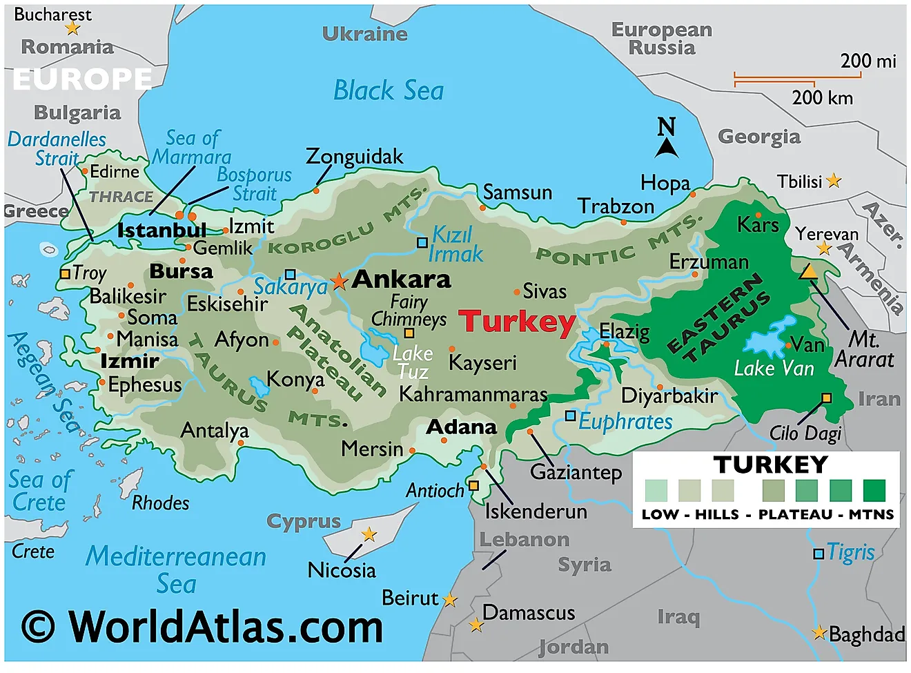
Turkey is a transcontinental country located between the Black Sea (to the north) and the Mediterranean Sea (to the south).
The western part (Thrace) is in Europe; the eastern part (Anatolia/Asia Minor) is in Asia, separated by the Bosphorus Strait, Sea of Marmara, and Dardanelles.
Why others are wrong:
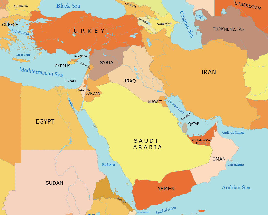
(a) Black Sea and Caspian Sea — the Caspian Sea is much further east (bordered by Iran, Azerbaijan, Turkmenistan, Kazakhstan, Russia). Turkey doesn't touch it.
(c) Gulf of Suez — that's in Egypt (Sinai Peninsula).
(d) Gulf of Aqaba and Dead Sea — those are between Israel, Jordan, Egypt, and Saudi Arabia.
Key geographic fact: Turkey controls the strategically vital Turkish Straits (Bosphorus + Dardanelles) connecting the Black Sea to the Mediterranean.
Turkey controls the Turkish Straits (Bosphorus and Dardanelles), which are the only passage connecting the Black Sea to the Mediterranean Sea.
This question tests basic location knowledge by mixing Turkey's actual position with water bodies from completely different regions like Egypt and the Levant.
Turkey's Geographic Location
Geography Turkey Black Sea Mediterranean Sea
Turkey's Geographic Location: Between Two Seas
Turkey is located between Black Sea (north) and Mediterranean Sea (south)
Transcontinental country: Thrace in Europe, Anatolia in Asia
Does NOT touch Caspian Sea, Gulf of Suez, Gulf of Aqaba, or Dead Sea
Controls Turkish Straits (Bosphorus + Dardanelles) connecting Black Sea to Mediterranean
Strategic Position
Turkey occupies a unique transcontinental position straddling Europe and Asia. This location makes it a natural bridge between the Black Sea and Mediterranean Sea, giving it immense strategic importance.
Turkey's Geographic Components
Region | Continent | Water Body | Key Features |
|---|---|---|---|
Thrace | Europe | Black Sea (north) | European part, smaller portion |
Anatolia/Asia Minor | Asia | Mediterranean Sea (south) | Asian part, major landmass |
Turkish Straits | Both | Connects both seas | Bosphorus, Sea of Marmara, Dardanelles |
Turkey's Position
Source: World Atlas — Turkey Maps & Facts - World Atlas · www.worldatlas.com
Question Context
This question tests knowledge of Turkey's fundamental geographic position. The correct answer (B) identifies the two major water bodies that define Turkey's northern and southern boundaries.
Caspian Sea is much farther east - bordered by Iran, Azerbaijan, Russia, not Turkey
Gulf of Suez is in Egypt near Sinai Peninsula, nowhere near Turkey
Gulf of Aqaba and Dead Sea are in the Israel-Jordan-Egypt region, not Turkey
Don't confuse Turkey's location with other Middle Eastern countries
Turkish Straits System
Geography Bosphorus Dardanelles
Turkish Straits: Connecting Black Sea to Mediterranean
Turkish Straits = Bosphorus + Sea of Marmara + Dardanelles
Only waterway connecting Black Sea to Mediterranean Sea
Separates European Turkey (Thrace) from Asian Turkey (Anatolia)
Strategic chokepoint for Russian and Black Sea nations' maritime access
Water Flow Path
%%{init: {"flowchart": {"wrappingWidth": 460}}}%%
flowchart TD
  s1["`**Black Sea**
Northern water body`"]
  s2["`**Bosphorus Strait**
Narrow strait through Istanbul`"]
  s3["`**Sea of Marmara**
Internal sea`"]
  s4["`**Dardanelles Strait**
Connects to Aegean`"]
  s5["`**Aegean Sea → Mediterranean**
Reaches Mediterranean Sea`"]
  s1 --> s2
  s2 --> s3
  s3 --> s4
  s4 --> s5
Components of Turkish Straits
Component | Length | Width | Significance |
|---|---|---|---|
Bosphorus | ~30 km | 0.7-3 km | Divides Istanbul, Europe-Asia boundary |
Sea of Marmara | 280 km long | 80 km wide | Internal sea between straits |
Dardanelles | ~65 km | 1.2-6 km | Ancient Hellespont, WWI Gallipoli campaign |
Strategic Importance
Only sea route for Russia and other Black Sea nations to reach warm-water ports
Controlled by Montreux Convention (1936) - Turkey manages passage rights
Critical for oil and gas exports from Caspian region
Historical battleground - Gallipoli Campaign (1915) fought here
Don't confuse Bosphorus (in Turkey) with Bering Strait (between Russia-Alaska)
Dardanelles is the ancient Hellespont - same waterway, different names
Turkish Straits are NOT the same as Strait of Gibraltar (Atlantic-Mediterranean connection)
Major Seas Around Middle East
Geography Black Sea Caspian Sea Mediterranean Sea
Major Seas & Water Bodies: Middle East Region
Black Sea - northern boundary of Turkey, connects via Turkish Straits
Caspian Sea - world's largest lake, bordered by Iran/Russia/Central Asia
Mediterranean Sea - southern boundary of Turkey, connects to Atlantic
Red Sea - between Africa and Arabian Peninsula, has Gulf of Suez/Aqaba
Key Water Bodies Comparison
Water Body | Type | Key Bordering Countries | Connection |
|---|---|---|---|
Black Sea | Sea | Turkey, Russia, Ukraine, Bulgaria | Turkish Straits → Mediterranean |
Caspian Sea | Lake (enclosed) | Iran, Russia, Azerbaijan, Kazakhstan | No sea connection |
Mediterranean Sea | Sea | Turkey, Greece, Italy, Spain, Egypt | Gibraltar → Atlantic |
Red Sea | Sea | Egypt, Sudan, Saudi Arabia, Yemen | Suez Canal → Mediterranean |
Arabian/Persian Gulf | Gulf | Iran, Iraq, Kuwait, Saudi Arabia, UAE | Strait of Hormuz → Arabian Sea |
Regional Water Bodies
Source: GIS Geography — Map Collection of the Middle East - GIS Geography · gisgeography.com
UPSC-Relevant Facts
Caspian Sea is technically a lake (enclosed) - world's largest by surface area
Black Sea gets its name from frequent storms and dark appearance
Mediterranean means 'middle of the earth' - between Europe, Africa, Asia
Dead Sea (between Israel-Jordan) is actually a salt lake, not connected to oceans
Caspian Sea location: Iran-Russia-Central Asia, NOT near Turkey
Gulf of Suez is in Egypt (Red Sea extension), not Turkey region
Gulf of Aqaba is between Saudi Arabia-Egypt-Israel-Jordan, not Turkey
Don't mix up Black Sea (Turkey's north) with Red Sea (Egypt-Saudi Arabia)