What is the correct sequence of occurrence of the following cities in South-East Asia as one proceeds from south to north? 1. Bangkok 2. Hanoi 3. Jakarta 4. Singapore Select the correct answer using the code given below:
Contents11
- A4-2-1-3
- B3-2-4-1
- C3-4-1-2
- D4-3-2-1
Show answer
Answer: (C) 3-4-1-2
South to North latitudinal order:
Jakarta (6°S — Southern Hemisphere, the southernmost)
→ Singapore (1°N — almost on the Equator)
→ Bangkok (14°N)
→ Hanoi (21°N — the northernmost).
So the sequence is 3-4-1-2.
How to remember:
Jakarta is BELOW the equator (south of it).
Singapore is right AT the equator.
Bangkok is in the tropics.
Hanoi is the farthest north, close to the Tropic of Cancer.
Common mistake:
Students confuse Singapore and Jakarta.
Singapore feels more 'developed/modern' so they assume it's further north, but Jakarta is actually further SOUTH (below the equator).
Always verify with a mental map.
Jakarta is the only major Southeast Asian capital located in the Southern Hemisphere, below the equator at approximately 6°S latitude.
Students often incorrectly assume Singapore is further south than Jakarta because Singapore appears more prominent on world maps, but Jakarta is actually below the equator while Singapore sits at 1°N.
The question tests spatial reasoning skills by requiring students to visualize the north-south arrangement of major regional capitals rather than just memorizing facts.
Southeast Asia City Latitudes
Geography Bangkok Hanoi Jakarta Singapore south to north
Southeast Asia City Latitudes: South-North Positioning
Jakarta (6°S) is the only Southeast Asian major city below the equator
Singapore (1°N) sits almost exactly on the equator
Bangkok (14°N) is in the northern tropics
Hanoi (21°N) is the northernmost, close to Tropic of Cancer
UPSC tests latitudinal knowledge of major Southeast Asian cities to check students' mental mapping skills. The key insight: Jakarta is the only major city south of the equator in this region, while Hanoi extends furthest into the northern hemisphere.
Exact Latitudinal Positions
City | Country | Latitude | Hemisphere Position | Reference Point |
|---|---|---|---|---|
Jakarta | Indonesia | 6°S | Southern Hemisphere | Below equator |
Singapore | Singapore | 1°N | Northern Hemisphere | Almost on equator |
Bangkok | Thailand | 14°N | Northern Hemisphere | Between equator & Tropic of Cancer |
Hanoi | Vietnam | 21°N | Northern Hemisphere | Close to Tropic of Cancer (23.5°N) |
Southeast Asia Physical Map
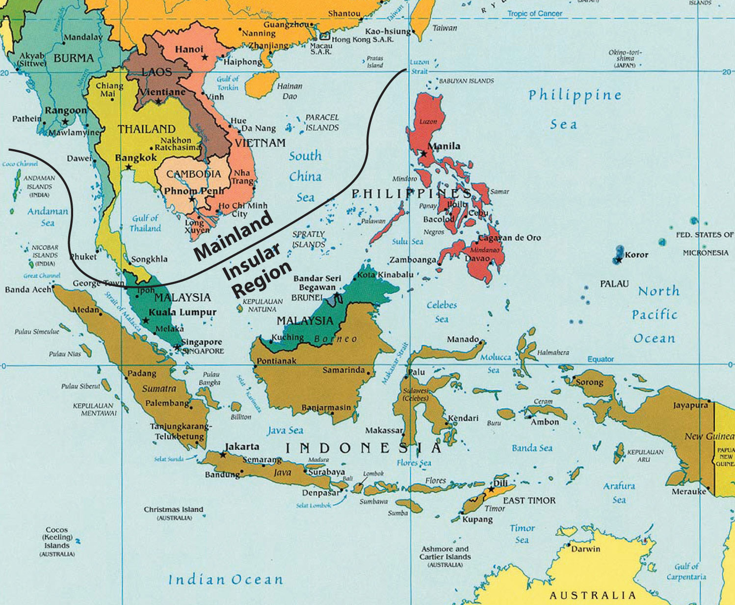
Source: saylordotorg.github.io — Southeast Asia · saylordotorg.github.io
Question Solution
The correct south-to-north sequence is 3-4-1-2: Jakarta (southernmost, below equator) → Singapore (equatorial) → Bangkok (tropical north) → Hanoi (northernmost). This translates to option C in the given question.
Jakarta-Singapore confusion: Students assume Singapore is further south because it's an island city-state, but Jakarta is actually 6° below the equator
Development bias: Don't assume more developed cities (Singapore) are automatically further north — check actual coordinates
Thailand-Vietnam mix-up: Bangkok appears more 'central' in news, but Hanoi is actually 7° further north
Hemisphere trap: Only Jakarta is in Southern Hemisphere among these four cities
Southeast Asian Capitals & Geography
Geography Bangkok Hanoi Jakarta Singapore
Major Southeast Asian Cities: Countries & Strategic Positions
Bangkok - Thailand's capital, major Mekong Delta hub
Hanoi - Vietnam's capital, northern Vietnam administrative center
Jakarta - Indonesia's capital, largest archipelagic nation's center
Singapore - city-state, major maritime trade hub
City Profiles & Strategic Importance
City | Country | Status | Strategic Location | Key Feature |
|---|---|---|---|---|
Bangkok | Thailand | Capital | Chao Phraya River delta | ASEAN headquarters |
Hanoi | Vietnam | Capital | Red River delta | Northern Vietnam admin center |
Jakarta | Indonesia | Capital | Northwest Java coast | Largest archipelagic nation |
Singapore | Singapore | City-state | Southern tip of Malay Peninsula | Major shipping hub, Strait of Malacca |
Economic & Geographic Significance
Singapore controls the Strait of Malacca, world's busiest shipping lane
Bangkok serves as mainland Southeast Asia's economic hub with ASEAN Secretariat
Jakarta governs 17,000+ islands of Indonesia, world's largest archipelago
Hanoi manages Vietnam's Red River Delta, major rice-producing region
Southeast Asian Regional Groupings
# Southeast Asia
## Mainland
- Thailand (Bangkok)
- Vietnam (Hanoi)
- Myanmar
- Laos
- Cambodia
## Maritime
- Indonesia (Jakarta)
- Malaysia
- Philippines
- Brunei
## City-States
- SingaporeCapital confusion: All four cities are national capitals except Singapore is both city and country
Island vs Mainland: Jakarta (island nation capital) vs Bangkok/Hanoi (mainland capitals) - don't mix geographic categories
ASEAN mix-up: Bangkok hosts ASEAN Secretariat, not Singapore despite Singapore's prominence
Equator & Tropical Reference Lines
Geography south to north equator
Equator & Tropics: Key Latitude Reference Lines
Equator at 0° divides Earth into Northern and Southern hemispheres
Tropic of Cancer at 23.5°N marks northern limit of direct sun rays
Tropic of Capricorn at 23.5°S marks southern limit of direct sun rays
These reference lines help determine climate zones and seasonal patterns. Cities' positions relative to these lines explain their temperature ranges, monsoon patterns, and daylight variations throughout the year.
Major Latitude Lines & Significance
Reference Line | Latitude | Significance | Climate Implication |
|---|---|---|---|
Tropic of Cancer | 23.5°N | Northern boundary of tropics | Direct sun rays during June solstice |
Equator | 0° | Earth's center line | Consistent day-night length year-round |
Tropic of Capricorn | 23.5°S | Southern boundary of tropics | Direct sun rays during December solstice |
Sun's Position Throughout Year
%%{init: {"flowchart": {"wrappingWidth": 460}}}%%
flowchart TD
  s1["`**March Equinox**
Sun directly above **Equator** - equal day/night globally`"]
  s2["`**June Solstice**
Sun directly above **Tropic of Cancer** - longest day in Northern Hemisphere`"]
  s3["`**September Equinox**
Sun returns to **Equator** - equal day/night again`"]
  s4["`**December Solstice**
Sun directly above **Tropic of Capricorn** - longest day in Southern Hemisphere`"]
  s1 --> s2
  s2 --> s3
s3 --> s4Hemisphere confusion: Negative latitudes (°S) = Southern Hemisphere, Positive (°N) = Northern Hemisphere
Tropic reversal: Cancer is North (think hot summer), Capricorn is South
23.5° precision: UPSC may test exact values - both tropics are 23.5° from equator, not 23° or 24°