Between India and East Asia, the navigation-time and distance can be greatly reduced by which of the following? 1. Deepening the Malacca straits between Malaysia and Indonesia. 2. Opening a new canal across the Kra isthmus between the Gulf of Siam and Andaman Sea. Which of the statements given above is/are correct?
Contents20
- A1 only
- B2 only
- CBoth 1 and 2
- DNeither 1 nor 2
Show answer
Answer: (B) 2 only
Correct Answer: B (2 only)
Why Statement 1 is Incorrect
- The Issue: The Malacca Strait is already a open, natural waterway. The primary bottleneck is its heavy traffic and narrow width, not its depth.
- The Reality: Deepening the strait will not change its geographic length. Because it doesn't create a shortcut, it would not reduce the actual navigation distance or time between India and East Asia.
Why Statement 2 is Correct
- The Concept: The Kra Isthmus is the narrowest stretch of land on the Malay Peninsula.
- The Impact: Opening a new artificial canal through this isthmus would connect the Andaman Sea directly to the Gulf of Thailand.
- The Result: Ships could completely bypass the long detour through the Malacca Strait, cutting down the transit distance by roughly 1,200 kilometers (approx. 700 miles) and significantly saving navigation time.
Quick Summary
- Malacca Strait: Deepening it does not shorten the route.
- Kra Isthmus: Building a canal here creates a physical shortcut, directly reducing distance and time.
The Malacca Strait handles about 25% of global traded goods but is extremely shallow, forcing ships to reduce cargo or take longer routes.
The proposed Kra Canal across Thailand's narrowest point could cut 2-3 days from India-East Asia shipping by bypassing the entire Malacca route.
UPSC is testing whether students understand that maritime chokepoints can be improved through both deepening existing routes and creating alternative passages.
Malacca Strait - World's Busiest Sea Route
Geography Malacca straits Malaysia and Indonesia
Malacca Strait: Geography, Trade Importance & Navigation Challenges
Malacca Strait connects Indian and Pacific Oceans between Malaysia and Indonesia
World's busiest shipping lane - 25% of global trade passes through
Major navigation bottleneck due to shallow depths and narrow width
Deepening would allow larger ships and reduce transit time
Strategic Location
The Malacca Strait is the primary sea route connecting India with East Asia, running between Malaysia and Indonesia. Despite being only 2.8 km wide at its narrowest point, it handles massive shipping traffic because it's the shortest route between the Indian and Pacific Oceans.
Key Geographic Facts
Aspect | Details | Significance |
|---|---|---|
Length | 800 km | Longest strait in the world |
Narrowest Width | 2.8 km (Phillips Channel) | Creates navigation bottleneck |
Depth | 25 meters (shallowest point) | Limits size of ships that can pass |
Countries | Malaysia, Indonesia, Singapore | Joint management and security |
Strait Location

Source: The Prayas India — Strait of Malacca - The Prayas India · theprayasindia.com
Why Deepening Helps
Larger ships can transit without waiting for high tide
Reduced draft restrictions allow fully loaded container vessels
Faster transit as ships don't need to reduce speed in shallow areas
Lower shipping costs due to economies of scale with bigger vessels
Trap: Confusing Malacca Strait with Palk Strait (India-Sri Lanka)
Trap: Thinking deepening is impossible - it's technically feasible but expensive
Trap: Missing that both Malaysia and Indonesia border the strait, not just one country
Kra Canal - Proposed Maritime Shortcut
Geography Kra isthmus Gulf of Siam Andaman Sea
Kra Canal Project: The Proposed Thai Canal to Rival Suez
Kra Isthmus is narrowest part of Malay Peninsula in southern Thailand
Proposed canal would connect Andaman Sea and Gulf of Thailand
Would save 2-3 days sailing time between India and East Asia
Project remains under discussion due to high costs and environmental concerns
Geographic Advantage
The Kra Isthmus in southern Thailand is only 44 km wide at its narrowest point. A canal here would create a direct shortcut between the Andaman Sea and Gulf of Thailand, eliminating the need for ships to travel around the entire Malay Peninsula through the crowded Malacca Strait.
Kra Canal vs Current Route
Route Aspect | Via Malacca Strait | Via Kra Canal | Benefit |
|---|---|---|---|
Distance | 1,200 km longer | Direct shortcut | Significant fuel savings |
Time Saved | Current standard | 2-3 days less | Faster delivery |
Congestion | Heavy traffic delays | New uncrowded route | Predictable transit times |
Ship Size | Draft restrictions | Can be designed for larger vessels | Accommodate mega-ships |
Canal Location

Source: CivilsDaily — Isthmus of Kra Land Bridge Project - Civilsdaily · www.civilsdaily.com
Project Challenges
Environmental impact on local ecosystems and fishing communities
Geopolitical concerns from Malaysia and Singapore (would lose transit revenue)
High construction cost estimated at $20-30 billion
Security implications - creating new chokepoint under Thai control
Trap: Thinking Kra Canal already exists - it's still a proposed project
Trap: Confusing Gulf of Siam with Gulf of Thailand (same body of water, different names)
Trap: Missing that the canal is in Thailand, not Malaysia or Myanmar
India-East Asia Maritime Trade Routes
Geography India and East Asia navigation-time and distance
India-East Asia Trade: Current Routes & Bottlenecks
India-East Asia trade heavily depends on Southeast Asian sea routes
Malacca Strait is the primary but congested route
Route optimization saves significant time and fuel costs
Alternative routes through Sunda and Lombok straits are longer
Trade Volume Significance
India's trade with East Asian economies (China, Japan, South Korea, ASEAN) accounts for over 30% of India's total maritime trade. Most cargo ships from Indian ports like Mumbai, Chennai, and Kolkata must transit through Southeast Asian waterways to reach East Asian destinations.
Major Trade Routes
Route | Key Passages | Distance from Mumbai | Main Challenge |
|---|---|---|---|
Primary Route | Malacca Strait | 4,500 km to Shanghai | Congestion and depth limits |
Alternative 1 | Sunda Strait (Indonesia) | 5,200 km to Shanghai | 700 km longer route |
Alternative 2 | Lombok Strait (Indonesia) | 5,400 km to Shanghai | 900 km longer route |
Proposed | Via Kra Canal | 3,800 km to Shanghai | Canal doesn't exist yet |
Economic Impact of Route Optimization
Fuel savings of $10,000-15,000 per voyage for container ships
Time savings allow more round trips per year
Reduced insurance costs due to shorter exposure to piracy-prone areas
Lower inventory costs for just-in-time manufacturing supply chains
India's East Asia Trade Partners
# India-East Asia Trade
## **China**
- Largest trade partner
- Electronics imports
- Pharmaceuticals exports
## **ASEAN**
- Singapore hub
- Palm oil imports
- IT services exports
## **Japan**
- Auto components
- Steel imports
- Investment flows
## **South Korea**
- Shipbuilding
- Electronics
- Chemicals tradeTrap: Thinking air routes are the main trade connection - 95% goes by sea
Trap: Forgetting that both directions (India→East Asia and East Asia→India) benefit from route improvements
Trap: Missing the economic significance - this isn't just about geography, it's about trade facilitation
Asian Maritime Chokepoints
Geography
Asian Maritime Chokepoints: Strategic Straits & Canals
Maritime chokepoints are narrow passages critical for global shipping
Malacca, Hormuz, and Suez are the world's most important chokepoints
Disruption at any chokepoint can spike global oil and trade prices
Countries seek alternative routes to reduce dependency
Definition & Importance
Maritime chokepoints are narrow sea passages where large volumes of shipping must pass through restricted waters. These strategic locations can control global trade flows and become geopolitical flashpoints because disruption here affects worldwide supply chains.
Major Asian Chokepoints
Chokepoint | Location | % of Global Trade | Key Vulnerability | Alternative Routes |
|---|---|---|---|---|
Strait of Malacca | Malaysia-Indonesia | 25% | Piracy, shallow depth | Sunda, Lombok straits |
Strait of Hormuz | Iran-Oman | 20% of oil | Iran tensions | Pipelines to Red Sea |
Suez Canal | Egypt | 12% | Political instability | Cape of Good Hope |
Taiwan Strait | China-Taiwan | Vital chips | Military tensions | Routes around Philippines |
Asian Chokepoints Map
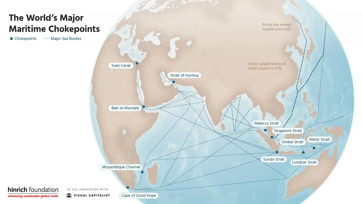
Source: Hinrich Foundation — The World's Major Maritime Chokepoints | Infographic | Hinrich ... · www.hinrichfoundation.com
Strategic Implications
Economic leverage - controlling nations can influence global trade
Military significance - naval powers focus on chokepoint control
Insurance costs rise in conflict-prone chokepoint areas
Supply chain resilience requires alternative route planning
Energy security heavily dependent on Hormuz and Malacca
Trap: Confusing Strait of Malacca with Strait of Hormuz - different oceans, different commodities
Trap: Thinking chokepoints only matter for oil - they affect all maritime trade
Trap: Missing that India is vulnerable to chokepoint disruption for both imports and exports