Which one of the following ancient towns is well-known for its elaborate system of water harvesting and management by building a series of dams and channelizing water into connected reservoirs?
Contents13
- ADholavira
- BKalibangan
- CRakhigarhi
- DRopar
Show answer
Answer: (A) Dholavira
Dholavira, on Khadir island in the Rann of Kutch, Gujarat, is famous for its remarkable water harvesting system.
The region receives very little rainfall and is drought-prone, so the Harappan inhabitants built dams across two flanking streams (Manhar and Mandsar) to channel rainwater into connected reservoirs.
Kalibangan (Rajasthan) is known for its ploughed field and fire altars.
Rakhigarhi (Haryana) is the largest Indus Valley site in India.
Ropar (Punjab) was the first Indus Valley site discovered after independence.
Dholavira's sophisticated water management system with 16 reservoirs demonstrates advanced Harappan engineering in one of the world's driest regions.
Dholavira became a UNESCO World Heritage Site in 2021, making its unique water harvesting techniques a current topic for UPSC.
The question tests specific site knowledge rather than general Harappan features - each major site has distinct specializations like Kalibangan's fire altars or Rakhigarhi's size.
Dholavira Water Management System
Ancient And Medieval History Dholavira water harvesting dams reservoirs
Dholavira: Advanced Water Harvesting in the Harappan Civilization
Dholavira is famous for its elaborate water harvesting system with dams and connected reservoirs
Located on Khadir island in the Rann of Kutch, Gujarat
Built dams across Manhar and Mandsar streams to channel rainwater
Designed to cope with drought-prone conditions and minimal rainfall
Why This System
Dholavira was built in one of the harshest environments of the Harappan civilization. The Rann of Kutch receives very little rainfall and is extremely drought-prone, forcing the inhabitants to develop sophisticated water management techniques for survival.
Water Management Process
%%{init: {"flowchart": {"wrappingWidth": 460}}}%%
flowchart TD
  s1["`**Dam Construction**
Built dams across **Manhar and Mandsar streams** flanking the settlement`"]
  s2["`**Water Collection**
Captured rainwater and seasonal stream flow during monsoons`"]
  s3["`**Channelization**
Directed water through planned channels into the settlement`"]
  s4["`**Storage**
Stored water in **connected reservoirs** for year-round use`"]
  s1 --> s2
  s2 --> s3
  s3 --> s4
Dholavira Layout
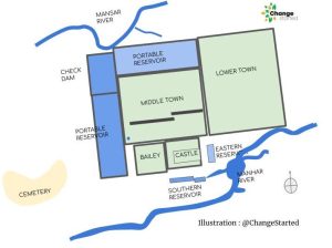
Source: Change Started — Water management System at Dholavira Civilization · changestarted.com
Engineering Features
16 reservoirs of varying sizes connected through channels
Rock-cut reservoirs lined with stones to prevent seepage
Cascading system where overflow from one reservoir fed into the next
Storm water drains integrated with the reservoir network
Total water storage capacity estimated at 10 million liters
Dholavira is the water management site, not Kalibangan (known for ploughed fields)
Don't confuse with Lothal (known for dockyard) - both are Gujarat Harappan sites
Location is Khadir island in Rann of Kutch, not mainland Gujarat
Major Harappan Sites & Key Features
Ancient And Medieval History Kalibangan Rakhigarhi Ropar
Key Harappan Sites: Distinctive Features for UPSC
Kalibangan (Rajasthan): ploughed field and fire altars
Rakhigarhi (Haryana): largest Indus Valley site in India
Ropar (Punjab): first IVC site discovered after independence
Dholavira (Gujarat): elaborate water management system
Site-Specific Features
Site | Location | Key Discovery | Significance |
|---|---|---|---|
Dholavira | Gujarat (Rann of Kutch) | Water harvesting system | Advanced hydraulic engineering |
Kalibangan | Rajasthan | Ploughed field & fire altars | Evidence of agriculture & ritual |
Rakhigarhi | Haryana | Urban settlement | Largest IVC site in India |
Ropar | Punjab | Post-independence discovery | First site found after 1947 |
Harappa | Pakistan | Type site | Gave name to civilization |
Mohenjodaro | Pakistan | Great Bath | Urban planning excellence |
Lothal | Gujarat | Dockyard | Maritime trade evidence |
Harappan Sites Map

Source: LotusArise — Harappan Sites - UPSC Notes » LotusArise IAS · lotusarise.com
UPSC Pattern Recognition
Site-feature matching is the most common question type
Gujarat sites: Dholavira (water), Lothal (dockyard), Surkotada (horse remains)
Rajasthan sites: Kalibangan (ploughed field), Balathal (copper smelting)
Largest to smallest: Rakhigarhi > Mohenjodaro > Harappa > Dholavira
Chronology matters: Ropar was first post-1947 discovery in India
Don't mix Lothal (dockyard) with Dholavira (water system) - both Gujarat sites
Rakhigarhi is largest in India, but Mohenjodaro was largest overall discovery
Kalibangan has fire altars, not Dholavira - different ritual vs practical focus
Ropar is post-1947 discovery significance, not archaeological feature significance
Harappan Urban Planning & Engineering
Ancient And Medieval History elaborate system town planning
Harappan Urban Planning: World's First Planned Cities
Grid pattern streets with main roads running north-south and east-west
Advanced drainage system with covered drains and manholes
Standardized bricks in ratio 4:2:1 used across all sites
Public utilities including wells, baths, and granaries
Planning Excellence
The Harappan civilization created the world's first planned cities around 2600-1900 BCE. Every major site shows evidence of systematic urban planning with standardized measurements, suggesting central authority and advanced administrative systems.
Urban Planning Elements
# Harappan Urban Planning
## Street System
- Grid pattern layout
- Wide main streets
- Narrow side lanes
- Right-angle intersections
## Drainage
- Covered drains
- House connections
- Manholes for cleaning
- Soakage pits
## Construction
- Standardized bricks
- Burnt brick usage
- Uniform measurements
- Strong foundations
## Public Facilities
- Community wells
- Public baths
- Granaries
- Market areas
Engineering Innovations
Covered drainage system - unique for its time, with house drains connecting to street drains
Standardized weights and measures - uniform across 1400+ sites spanning 1.5 million sq km
Citadel and Lower Town division - administrative and residential area separation
Fire-baked bricks - superior to contemporary sun-dried bricks used elsewhere
Water management - from simple wells (most sites) to complex systems (Dholavira)
Urban planning was common to all major sites, but water harvesting was unique to Dholavira
Don't confuse drainage systems (all sites) with water storage systems (mainly Dholavira)
Grid pattern doesn't mean perfect rectangles - streets adapted to local geography