With reference to India's projects on connectivity, consider the following statements: 1. East-West Corridor under Golden Quadrilateral Project connects Dibrugarh and Surat. 2. Trilateral Highway connects Moreh in Manipur and Chiang Mai in Thailand via Myanmar. 3. Bangladesh-China-India-Myanmar Economic Corridor connects Varanasi in Uttar Pradesh with Kunming in China. How many of the above statements are correct?
Contents15
- AOnly one
- BOnly two
- CAll three
- DNone
Show answer
Answer: (D) None
All three are wrong.
Statement 1: The East-West Corridor connects Silchar (Assam) to Porbandar (Gujarat), not Rajkot.
Statement 2: The India-Myanmar-Thailand Trilateral Highway connects Moreh (India) to Mae Sot (Thailand) via Myanmar, not directly to Ho Chi Minh City.
Statement 3: The BCIM Corridor runs from Kunming (China) through Myanmar and Bangladesh to Kolkata (India), not Lucknow.
Answer is (d).
India has multiple connectivity projects with neighboring countries as part of Act East Policy and regional integration efforts.
UPSC tests exact endpoints and routes of major connectivity corridors, not just their existence - students often confuse similar-sounding projects or mix up terminal cities.
The question checks whether students can distinguish between domestic highway projects like Golden Quadrilateral versus international connectivity corridors like BCIM and Trilateral Highway.
Golden Quadrilateral Project
Indian Economy Golden Quadrilateral Project East-West Corridor
Golden Quadrilateral Project: India's Highway Network
Golden Quadrilateral connects 4 metros: Delhi-Mumbai-Chennai-Kolkata via 5,846 km highways
East-West Corridor connects Silchar (Assam) to Porbandar (Gujarat) - 3,300 km
North-South Corridor connects Srinagar to Kanyakumari - 4,076 km
Implemented by NHAI under Ministry of Road Transport & Highways
Core Infrastructure
The Golden Quadrilateral forms India's primary highway backbone connecting major economic centers. Combined with North-South and East-West Corridors, it creates the National Highways Development Project (NHDP) Phase I and II.
Key Corridors
Corridor | Route | Length | Purpose |
|---|---|---|---|
Golden Quadrilateral | Delhi-Mumbai-Chennai-Kolkata | 5,846 km | Connect 4 metros |
East-West Corridor | Silchar (Assam) to Porbandar (Gujarat) | 3,300 km | East-West connectivity |
North-South Corridor | Srinagar to Kanyakumari | 4,076 km | North-South connectivity |
Highway Network Map
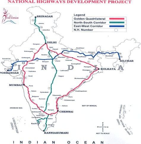
Source: x.com — ✓ Golden Quadrilateral - It is a network of highways connecting India's four top metropolitan cities, namely Delhi, Mumbai, Chennai and Kolkata, thereby, forming a quadrilateral. The largest highway project in India, · x.com
Trap: East-West Corridor connects Silchar to Porbandar, NOT Dibrugarh to Surat
Trap: Don't confuse Golden Quadrilateral cities with other economic corridors
Trap: NHDP phases cover different corridor combinations - know Phase I vs Phase II
India-Myanmar-Thailand Trilateral Highway
World Affairs (International Relations) Trilateral Highway Moreh Chiang Mai
India-Myanmar-Thailand Trilateral Highway: Act East Connectivity
Connects Moreh (India) to Mae Sot (Thailand) via Myanmar - 1,360 km total
Part of Act East Policy to boost trade with ASEAN countries
India contributed $128 million for Myanmar portion construction
Strategic Purpose
This highway operationalizes India's Act East Policy by creating land connectivity to Southeast Asia. It bypasses sea routes and reduces transportation costs for trade with ASEAN nations.
Route Details
Country | Start/End Points | Key Cities | Distance |
|---|---|---|---|
India | Moreh (Manipur) | Imphal | 110 km |
Myanmar | Tamu to Myawaddy | Kalewa, Monywa | 1,000 km |
Thailand | Mae Sot | Tak Province | 250 km |
Implementation Status
Phase 1: Moreh-Tamu section operational with border facilities
Phase 2: Myanmar section completed with 69 bridges and road upgrades
Extension planned: Mae Sot to Phitsanulok for Bangkok connectivity
Trap: Highway ends at Mae Sot, Thailand, NOT Chiang Mai
Trap: Don't confuse with Kaladan Multi-Modal Transit Transport project
Trap: This is trilateral (3 countries), not bilateral India-Myanmar only
BCIM Economic Corridor
World Affairs (International Relations) Bangladesh-China-India-Myanmar Economic Corridor Varanasi Kunming
BCIM Economic Corridor: Multi-Modal Regional Link
Connects Kunming (China) to Kolkata (India) via Myanmar and Bangladesh
Part of China's Belt and Road Initiative (BRI) - 2,800 km corridor
Includes roads, railways, waterways and economic zones
Concept & Scope
BCIM Corridor envisions seamless connectivity between South Asia and Southeast Asia through multi-modal transport. Originally proposed in 1999, it gained momentum under China's BRI framework.
Route & Components
Country | Key Cities | Transport Modes | Economic Zones |
|---|---|---|---|
China | Kunming, Ruili | Road, Rail | Kunming Economic Zone |
Myanmar | Muse, Mandalay, Yangon | Road, Rail, River | Border Economic Zones |
Bangladesh | Cox's Bazar, Chittagong, Dhaka | Road, Rail, Port | Chittagong Port |
India | Kolkata, Guwahati | Road, Rail, River | Kolkata Port, Industrial clusters |
Current Status
Study phase: Joint feasibility studies completed by all four countries
India's position: Cautious due to BRI concerns and border issues with China
Challenges: Political tensions, financing models, and sovereignty concerns
Trap: BCIM connects Kunming to Kolkata, NOT Kunming to Varanasi
Trap: This is economic corridor, not just highway like Trilateral Highway
Trap: Don't confuse BCIM sequence - it's Bangladesh-China-India-Myanmar alphabetically
India's Regional Connectivity Projects
World Affairs (International Relations)
India's Major Connectivity Initiatives: Comparison & Context
Domestic: Golden Quadrilateral, East-West & North-South Corridors
Act East: Trilateral Highway, Kaladan Project with Myanmar-Thailand
Regional: BCIM, International North-South Transport Corridor (INSTC)
Major Connectivity Projects
Project | Type | Route/Countries | Policy Framework |
|---|---|---|---|
Golden Quadrilateral | Domestic Highway | Delhi-Mumbai-Chennai-Kolkata | NHDP |
Trilateral Highway | International Road | India-Myanmar-Thailand | Act East Policy |
BCIM Corridor | Economic Corridor | Bangladesh-China-India-Myanmar | BRI (China-led) |
Kaladan Project | Multi-modal | India-Myanmar (Sittwe Port) | Act East Policy |
INSTC | Transport Corridor | India-Iran-Russia-Central Asia | Eurasian connectivity |
Connectivity Strategy
# India's Connectivity Vision
## **Domestic**
- Golden Quadrilateral
- East-West Corridor
- North-South Corridor
- Bharatmala Pariyojana
## **Act East**
- Trilateral Highway
- Kaladan Project
- ASEAN connectivity
## **Westward**
- Chabahar Port
- INSTC
- Iran connectivity
## **Regional**
- BCIM Corridor
- BBIN Initiative
- SAARC connectivityTrap: Each project has specific start-end points - don't mix up cities
Trap: Act East projects are India-led; BCIM is China's BRI initiative
Trap: Know which projects are operational vs under study vs stalled