Recently, which of the following States has explored the possibility of constructing an artificial inland port to be connected to sea by a long navigational channel?
Contents14
- AAndhra Pradesh
- BChhattisgarh
- CKarnataka
- DRajasthan
Show answer
Answer: (D) Rajasthan
Answer: (d) Rajasthan
Surprisingly, landlocked Rajasthan explored building an artificial inland port!
The Government of Rajasthan planned to develop an Inland Shipping Port at Jalore district, connected to the Arabian Sea by a navigational channel along the Kutch Creek in Gujarat.
Why this is tricky: Most students wouldn't associate Rajasthan (a desert state) with ports and sea connectivity.
But Rajasthan's southern border is not far from Gujarat's coast.
Why not the others?
- (a) Andhra Pradesh - Already has a long coastline.
- (b) Chhattisgarh - No such proposal.
- (c) Karnataka - Already has a coastline.
This was a difficult, factual current affairs question from a PIB press release.
Rajasthan, despite being landlocked and desert-dominated, proposed an inland port at Jalore connected to Arabian Sea via Gujarat's Kutch Creek around 2015-16.
The question tests whether students can think beyond obvious coastal states when it comes to port development - landlocked states can also develop sea connectivity through neighboring states.
This is pure current affairs from government press releases, testing specific knowledge of state infrastructure proposals rather than general economic concepts.
Rajasthan Artificial Inland Port Project
Indian Economy Rajasthan artificial inland port navigational channel
Rajasthan's Artificial Inland Port: Jalore-Kutch Creek Project
Rajasthan explored building an artificial inland port at Jalore district
Port would connect to Arabian Sea via navigational channel through Kutch Creek, Gujarat
Demonstrates how landlocked states seek sea connectivity for trade
The Surprise Factor
Rajasthan, known as India's desert state, explored connecting to the sea through an innovative inland port project. The proposal involved constructing an artificial port in Jalore district and linking it to the Arabian Sea via a long navigational channel.
Project Details
Location: Jalore district in Rajasthan's western region
Connection route: Navigational channel along Kutch Creek in Gujarat
Destination: Arabian Sea for international trade access
Rationale: Reduce transportation costs for landlocked Rajasthan's trade
Geographic advantage: Rajasthan's southern border is relatively close to Gujarat's coast
Geographic Context

Source: LinkedIn — India's ₹10,000 crore inland waterway project connects Rajasthan ... · www.linkedin.com
Question Context
This 2016 UPSC question tested knowledge of an unusual infrastructure proposal. The trap was assuming only coastal states would consider port projects, when landlocked Rajasthan actually explored innovative sea connectivity.
Trap: Assuming only coastal states develop ports - landlocked Rajasthan explored this project
Trap: Rejecting Rajasthan due to its desert image - the state actively sought Arabian Sea connectivity
Confusion: Other options like Andhra Pradesh and Karnataka already have natural coastlines
Inland Waterways Development in India
Indian Economy inland port navigational channel
India's Inland Waterways: Development & Connectivity Projects
Inland Waterways Authority of India (IWAI) develops and regulates inland water transport
India has 111 National Waterways declared for navigation
Inland waterways are cost-effective and environment-friendly transport mode
Jal Marg Vikas Project focuses on Ganga waterway development
Strategic Importance
Inland waterways offer cost-effective transportation for bulk cargo, reducing road congestion and transportation costs. India's vast river network provides natural corridors for developing multimodal connectivity between landlocked regions and seaports.
Major National Waterways
Waterway | River/Route | Length (km) | Key Features |
|---|---|---|---|
NW-1 | Ganga-Bhagirathi-Hooghly | 1,620 | Allahabad to Haldia, first declared |
NW-2 | Brahmaputra | 891 | Dhubri to Sadiya, Northeast connectivity |
NW-3 | West Coast Canal | 205 | Kollam to Kottapuram, Kerala |
NW-4 | Godavari-Krishna | 1,095 | Connects Andhra Pradesh and Telangana |
NW-5 | Brahmani-East Coast Canal | 623 | Odisha coastal connectivity |
Benefits for Landlocked States
Reduced transportation costs - waterways are 3-4 times cheaper than road transport
Enhanced trade access - connects interior regions to seaports
Environmental benefits - lower carbon emissions compared to road/rail
Cargo capacity - one barge equals 40 trucks or 3 railway rakes
Trap: Confusing IWAI (Inland Waterways Authority) with IWT (Inland Water Transport)
Confusion: NW-1 is Ganga system, not Brahmaputra - that's NW-2
Remember: 111 National Waterways declared, but only few are operationally developed
Coastal vs Landlocked States Infrastructure
Geography Andhra Pradesh Karnataka Chhattisgarh
India's Coastal States vs Landlocked States: Port Infrastructure
India has 9 coastal states with natural port access and 20 landlocked states
12 major ports and 200+ minor ports serve India's maritime trade
Landlocked states depend on multimodal connectivity for sea access
States in Question Options
State | Coastal Status | Major Ports | Key Infrastructure |
|---|---|---|---|
Andhra Pradesh | Coastal (Bay of Bengal) | Visakhapatnam | Natural deep-water ports |
Karnataka | Coastal (Arabian Sea) | New Mangalore | Major, Minor ports available |
Chhattisgarh | Landlocked | None | Depends on Gujarat/Odisha ports |
Rajasthan | Landlocked | None | Uses JNPT, Kandla ports via road/rail |
India's Port Classification
# Indian Ports
## Major Ports (12)
- Central Government
- Deep water
- International trade
- Examples: Mumbai, Chennai
## Minor Ports (200+)
- State Government
- Coastal trade
- Fishing harbors
- Examples: Beypore, Porbandar
## Inland Ports
- River/canal based
- Cargo handling
- Multimodal hubs
- Examples: Varanasi, Patna
Landlocked State Challenges
Higher logistics costs - additional road/rail transport to reach ports
Time delays - longer supply chains affect competitiveness
Port congestion - dependence on limited gateway ports
Innovative solutions - artificial ports, inland waterways, dedicated freight corridors
India's Port Distribution
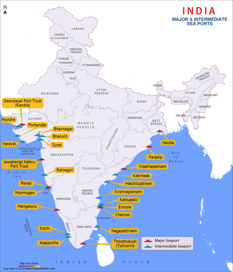
Source: India Map — Major Sea Ports Map, Seaports in India · www.mapsofindia.com