With reference to ancient India (600–322 BC), consider the following pairs:
Contents11
With reference to ancient India (600–322 BC), consider the following pairs:
| Territorial Region | River flowing in the region | |
|---|---|---|
| I. | Asmaka | Godavari |
| II. | Kamboja | Vipas |
| III. | Avanti | Mahanadi |
| IV. | Kosala | Sarayu |
How many of the pairs given above are correctly matched?
- AOnly one
- BOnly two
- COnly three
- DAll the four
Show answer
Answer: (B) Only two
This question tests knowledge of the Mahajanapadas (16 great kingdoms) of ancient India and the rivers associated with their regions:
(I) Asmaka — Godavari: CORRECT. Asmaka (also spelled Assaka) was located in the Deccan region, on the banks of the river Godavari. Its capital was Potana/Potali (modern Paithan in Maharashtra). It was the only Mahajanapada south of the Vindhyas. ✓
(II) Kamboja — Vipas (Beas): INCORRECT. Kamboja was located in the far northwest of the Indian subcontinent, in the area around modern-day Afghanistan/northern Pakistan (around the Hindukush mountains). It was associated with the Kabul River region, not the Vipas (Beas), which flows through Punjab. ✗
(III) Avanti — Mahanadi: INCORRECT. Avanti was located in western-central India (modern Malwa region of Madhya Pradesh), with its capital at Ujjain (northern Avanti) and Mahishmati (southern Avanti). It was associated with the Sipra (Kshipra) river, NOT the Mahanadi. The Mahanadi flows through Chhattisgarh and Odisha, which is much further east. ✗
(IV) Kosala — Sarayu: CORRECT. Kosala was located in the modern-day Awadh (eastern UP) region, with its capital at Ayodhya, which sits on the banks of the Sarayu river. This is also significant from the Ramayana context — Lord Rama's capital Ayodhya is on the Sarayu. ✓
Two pairs (I and IV) are correct. Answer is (b).
Asmaka was the only Mahajanapada located south of the Vindhya mountains, making it geographically distinct from the other 15 northern kingdoms.
UPSC tests Mahajanapadas through geography because it reveals how ancient political boundaries were shaped by river systems and natural barriers like the Vindhyas.
The question specifically tests whether students can distinguish between similar-sounding rivers and avoid confusing regional geography across different parts of ancient India.
Sixteen Mahajanapadas (600-322 BC)
Ancient And Medieval History Mahajanapadas Asmaka Kamboja Avanti Kosala
The Sixteen Mahajanapadas: Political Map of Pre-Mauryan India
16 great kingdoms existed during 600-322 BC in the Indian subcontinent
Asmaka was the only Mahajanapada south of Vindhyas, located on Godavari river
Kosala had capital at Ayodhya on Sarayu river - Lord Rama's kingdom
Avanti was in Malwa region with capitals at Ujjain and Mahishmati
The Mahajanapadas were 16 powerful kingdoms that emerged around 600 BC, marking the transition from tribal societies to organized states. These territories were contemporary to Buddha and Mahavira, representing the political landscape they encountered.
Key Mahajanapadas & Their Rivers
Mahajanapada | Capital | River | Modern Location |
|---|---|---|---|
Asmaka | Potana/Potali | Godavari | Maharashtra (Paithan) |
Kosala | Ayodhya | Sarayu | Eastern UP |
Avanti | Ujjain & Mahishmati | Sipra/Kshipra | Malwa (MP) |
Kamboja | Rajapura | Kabul River | Afghanistan/N. Pakistan |
Magadha | Rajgir → Pataliputra | Ganga | Bihar |
Vajji | Vaishali | Ganga | Bihar |
Kuru | Indraprastha | Yamuna | Delhi-Haryana |
Panchala | Ahichhatra & Kampilya | Ganga | Western UP |
Mahajanapadas Map
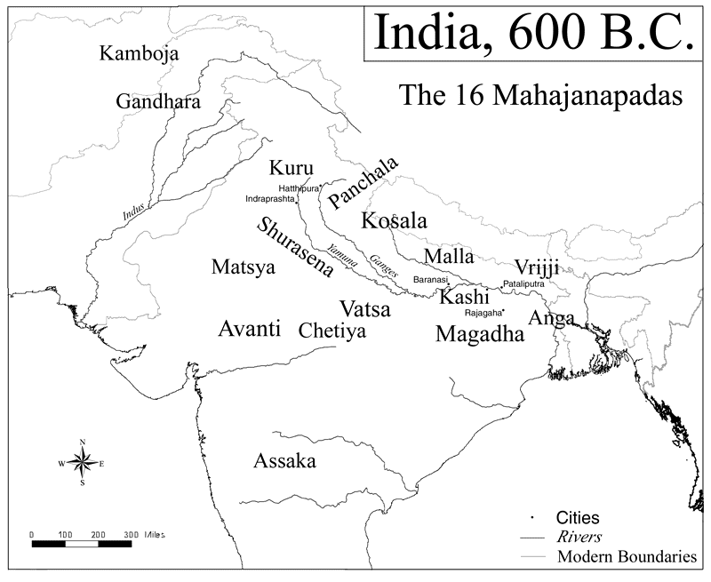
Source: World History Encyclopedia — Map of India, 600 BCE - World History Encyclopedia · www.worldhistory.org
Geographic Distribution
Northern cluster: Kamboja, Gandhara, Kuru, Panchala in modern Pakistan-North India
Central-Eastern belt: Kosala, Magadha, Vajji, Malla in Gangetic plains
Western regions: Avanti in Malwa, Surasena around Mathura
Southern outlier: Asmaka alone south of Vindhyas in Deccan plateau
Question Context
This PYQ tested river-territory associations. Asmaka-Godavari and Kosala-Sarayu were correctly paired, while Kamboja (northwest frontier) was wrongly linked to Vipas/Beas instead of Kabul River, and Avanti was incorrectly paired with Mahanadi instead of Sipra.
Trap: Confusing Asmaka (Deccan, south of Vindhyas) with northern kingdoms - it's the only southern Mahajanapada
Trap: Linking Avanti with Mahanadi - Avanti was in Malwa (MP), Mahanadi flows through Odisha-Chhattisgarh
Trap: Placing Kamboja in Punjab region - it was in far northwest (Afghanistan area), not Vipas/Beas region
Trap: Mixing up Kosala (Ayodhya-Sarayu) with Kashi (Varanasi-Ganga) - both are in UP but different rivers
Ancient Indian River Systems
Ancient And Medieval History Godavari Vipas Mahanadi Sarayu
Ancient River Names & Geographic Associations
Sarayu flows through Ayodhya - Kosala's capital and Rama's kingdom
Godavari is the major Deccan river - associated with Asmaka Mahajanapada
Vipas (ancient name) = Beas (modern) - flows through Punjab
Ancient vs Modern River Names
Ancient Name | Modern Name | Region | Associated Kingdom |
|---|---|---|---|
Sarayu | Sarayu/Ghaghra | Eastern UP | Kosala (Ayodhya) |
Godavari | Godavari | Maharashtra-AP | Asmaka (Potana) |
Vipas | Beas | Punjab | None (Kamboja was further west) |
Mahanadi | Mahanadi | Odisha-Chhattisgarh | None (no Mahajanapada here) |
Vitasta | Jhelum | Kashmir | None |
Sutudri | Sutlej | Punjab | None |
Yamuna | Yamuna | North India | Kuru (Indraprastha) |
River-Kingdom Logic
Capital cities were typically located on major rivers for water supply, trade, and defense
Godavari was the only major river in Deccan during Mahajanapada period - hence Asmaka's location
Northwestern rivers (Kabul, Kurram) were associated with frontier kingdoms like Kamboja
Eastern rivers like Mahanadi had no major political centers during 600-322 BC period

Source: Reddit — Geographical locations and other regions mentioned in Vedic ... · www.reddit.com
Trap: Sarayu vs Saryu - both refer to same river, don't get confused by spelling variations
Trap: Assuming all Vedic river names changed - Godavari and Mahanadi retained their ancient names
Trap: Placing Mahanadi kingdoms in ancient period - this eastern region had no major Mahajanapadas
Pre-Mauryan Political Geography
Ancient And Medieval History 600–322 BC ancient India
Political & Geographic Transformation (600-322 BC)
600-322 BC marks transition from tribal republics to organized kingdoms
Period saw rise of Buddhism (Buddha, 563-483 BC) and Jainism (Mahavira)
Magadha emerged as dominant power, leading to Mauryan Empire (322 BC)
The period 600-322 BC represents a crucial transformation in Indian political organization. This era saw the decline of Vedic tribal system and rise of territorial kingdoms with fixed boundaries, standing armies, and urban centers.
Political Evolution Timeline
%%{init: {"flowchart": {"wrappingWidth": 460}}}%%
flowchart TD
  s1["`**600 BC**
**16 Mahajanapadas** established as major political units`"]
  s2["`**563-483 BC**
**Buddha's lifetime** - religious transformation alongside political change`"]
  s3["`**550-450 BC**
**Magadha expansion** under Bimbisara and Ajatashatru`"]
  s4["`**400-350 BC**
**Nanda dynasty** consolidates Gangetic plains`"]
  s5["`**322 BC**
**Chandragupta Maurya** establishes Mauryan Empire`"]
  s1 --> s2
  s2 --> s3
  s3 --> s4
  s4 --> s5
Geographic Factors
Iron technology enabled forest clearing and agriculture expansion in Gangetic plains
River valleys became centers of power - Ganga for Magadha, Godavari for Asmaka
Trade routes connected kingdoms - northwestern routes brought foreign influence
Deccan plateau remained peripheral - only Asmaka among 16 Mahajanapadas
Trap: Confusing 600-322 BC with Mauryan period (322-185 BC) - question specifically asks pre-Mauryan
Trap: Assuming uniform development - northwestern and Deccan regions were less politically organized