Consider the following countries: I. Bolivia II. Brazil III. Colombia IV. Ecuador V. Paraguay VI. Venezuela Andes mountains pass through how many of the above countries?
Contents15
- AOnly two
- BOnly three
- COnly four
- DOnly five
Show answer
Answer: (C) Only four
The Andes is the longest continental mountain range in the world, stretching about 7,000 km along the western coast of South America.
It passes through seven countries: Venezuela, Colombia, Ecuador, Peru, Bolivia, Chile, and Argentina.
From the given list:
(I) Bolivia — YES. The Andes run through western Bolivia, including the Altiplano (high plateau) where La Paz is located. ✓
(II) Brazil — NO. Brazil is east of the Andes. Its terrain includes the Amazon Basin and the Brazilian Highlands, but not the Andes. ✗
(III) Colombia — YES. The Andes split into three cordilleras (ranges) in Colombia. ✓
(IV) Ecuador — YES. The Andes run through the center of Ecuador, with volcanoes like Cotopaxi and Chimborazo. ✓
(V) Paraguay — NO. Paraguay is a landlocked country in central South America, east of the Andes and west of Brazil. Its terrain is mostly flat lowlands and the Chaco region. ✗
(VI) Venezuela — YES. The northern end of the Andes extends into Venezuela (the Mérida Andes). ✓
Four countries from the list (Bolivia, Colombia, Ecuador, Venezuela) have the Andes. Answer is (c).
The Andes is the world's longest continental mountain range at approximately 7,000 km, stretching through seven South American countries along the western coast.
Students often confuse which countries have the Andes because Brazil and Paraguay are large South American countries, but the Andes only runs along the western side of the continent.
Andes Mountain Range - Overview
Geography Andes mountains longest continental mountain range
Andes Mountains: World's Longest Continental Range & Country Coverage
Longest continental mountain range in the world at 7,000 km
Runs along western coast of South America from north to south
Passes through 7 countries: Venezuela, Colombia, Ecuador, Peru, Bolivia, Chile, Argentina
Forms the backbone of South America separating Pacific coast from interior
The Andes form the spine of South America, stretching continuously along its western edge. This massive fold mountain system acts as a natural barrier between the Pacific coastal regions and the interior plains and plateaus.
Countries Through Which Andes Pass
Country | Andes Features | Notable Points |
|---|---|---|
Venezuela | Mérida Andes (northern terminus) | Northernmost extent |
Colombia | Three cordilleras (ranges) | Andes split into branches |
Ecuador | Central highlands, active volcanoes | Cotopaxi, Chimborazo peaks |
Peru | Highest peaks, Machu Picchu | Cultural significance |
Bolivia | Altiplano plateau, La Paz location | High altitude cities |
Chile | Entire eastern border | Longest stretch in one country |
Argentina | Aconcagua peak (highest) | Southern terminus |
Andes Location Map

Source: YouTube — Andes mountains pass through how many of the above countries? #geographyupsc · www.youtube.com
In the given PYQ, 4 out of 6 listed countries have the Andes passing through them: Bolivia (Altiplano region), Colombia (three cordilleras), Ecuador (central volcanoes), and Venezuela (northern Mérida range). Brazil and Paraguay lie east of the Andes and are not crossed by this mountain system.
Brazil confusion: Largest South American country but Andes don't pass through it - Brazil is east of the range
Paraguay trap: Landlocked country between Brazil and Argentina, but east of Andes in central lowlands
Missing countries: UPSC may test Peru, Chile, Argentina - the other 3 countries through which Andes pass
Length confusion: 7,000 km makes it longest continental range, not just longest overall
South American Countries - Andes vs Non-Andes
Geography Bolivia Brazil Colombia Ecuador Paraguay Venezuela
South American Countries: Andes Classification & Geographic Features
Andean countries: Venezuela, Colombia, Ecuador, Peru, Bolivia, Chile, Argentina
Non-Andean countries: Brazil, Paraguay, Uruguay, Guyana, Suriname, French Guiana
From PYQ list: 4 have Andes (Bolivia, Colombia, Ecuador, Venezuela), 2 don't (Brazil, Paraguay)
PYQ Countries Analysis
Country | Andes Present? | Key Geographic Features | Location Relative to Andes |
|---|---|---|---|
Bolivia | ✓ YES | Altiplano plateau, La Paz (world's highest capital) | Western region, landlocked |
Brazil | ✗ NO | Amazon Basin, Brazilian Highlands, Atlantic coast | East of Andes |
Colombia | ✓ YES | Three cordilleras, Caribbean & Pacific coasts | Northwestern South America |
Ecuador | ✓ YES | Galápagos Islands, active volcanoes, Pacific coast | Equatorial Andes region |
Paraguay | ✗ NO | Chaco region, Paraguay River, landlocked | East of Andes, central location |
Venezuela | ✓ YES | Orinoco Basin, Caribbean coast, Angel Falls | Northern terminus of Andes |
South American Geographic Division
# South America by Andes
## Andean Countries (7)
- Venezuela (north)
- Colombia
- Ecuador
- Peru
- Bolivia
- Chile
- Argentina (south)
## Non-Andean Countries (6)
- Brazil (largest)
- Paraguay
- Uruguay
- Guyana
- Suriname
- French Guiana
Key Geographic Patterns
Western alignment: All Andean countries have Pacific Ocean access except Bolivia (landlocked)
Eastern countries: Brazil and Paraguay are in the Atlantic drainage basin, not Pacific
Size paradox: Brazil is the largest South American country but has no Andes coverage
Altitude contrast: Andean countries have high altitude cities (La Paz 3,500m+), eastern countries mostly lowlands
Climate division: Andes create rain shadow effect separating Pacific coastal climate from interior patterns
Brazil size trap: Largest doesn't mean it covers all geographic features - no Andes in Brazil
Paraguay landlocked confusion: Being landlocked doesn't mean it has mountains - it's in eastern lowlands
Venezuela location: Northern country but does have Andes (Mérida range) - don't assume it's too far north
Missing Peru/Chile: Questions may include these obvious Andean countries to test if you know the complete list of 7
Major Mountain Ranges of the World
Geography
World's Major Mountain Ranges: Classification & Key Features
Andes: Longest continental range (7,000 km) in South America
Himalayas: Highest range with Mount Everest, spans Asia
Rocky Mountains: North America's major range, 4,800 km long
Alps: Europe's prominent fold mountains, formed by African-Eurasian collision
World's Longest Mountain Ranges
Mountain Range | Length (km) | Continent | Key Feature | Formation Type |
|---|---|---|---|---|
Andes | ~7,000 | South America | Longest continental range | Fold mountains |
Rocky Mountains | ~4,800 | North America | Extends Canada to New Mexico | Fold mountains |
Himalayas | ~2,400 | Asia | Highest peaks, Mt. Everest | Fold mountains |
Great Dividing Range | ~3,500 | Australia | Eastern coast range | Old fold mountains |
Urals | ~2,500 | Europe-Asia | Europe-Asia boundary | Old fold mountains |
Alps | ~1,200 | Europe | Central European peaks | Young fold mountains |
Mountain Range Formation Types
Young fold mountains: Andes, Himalayas, Alps - formed by recent plate collisions, high and rugged
Old fold mountains: Urals, Appalachians - formed earlier, now weathered and lower
Block mountains: Formed by faulting and uplift, like parts of African Rift system
Volcanic mountains: Formed by volcanic activity, often in island arcs or continental margins
Residual mountains: Old ranges worn down by erosion, like parts of Indian Peninsula
World Mountain Ranges Map
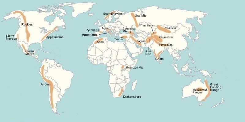
Source: LotusArise — Major Mountain Ranges of the World - UPSC Notes » LotusArise IAS · lotusarise.com
Length vs Height confusion: Andes is longest continental but Himalayas have highest peaks
Continental vs oceanic: Mid-ocean ridges are longer than Andes but are underwater mountain systems
Age classification: Don't confuse young fold (high, recent) with old fold (lower, weathered) mountains
Boundary ranges: Some ranges like Urals mark continental boundaries, not just geographic features
South American Physical Geography
Geography
South America: Major Physical Divisions & Geographic Features
Western region: Andes Mountains form continuous barrier along Pacific coast
Eastern region: Lowlands and plateaus including Amazon Basin and Brazilian Highlands
River systems: Amazon (Atlantic drainage) vs short Pacific coastal rivers
Climate division: Andes create rain shadow separating coastal and interior climates
South American Physical Divisions
# South America Physical Geography
## Western Highlands
- Andes Mountains
- Altiplano (Bolivia)
- Patagonian Andes
- Pacific coastal plains
## Eastern Lowlands
- Amazon Basin
- Orinoco Plains
- Pampas
- Chaco region
## Eastern Plateaus
- Brazilian Highlands
- Guiana Highlands
- Patagonian Plateau
## Island Regions
- Galápagos (Ecuador)
- Falklands
- Tierra del Fuego
Major Physical Features by Region
Physical Division | Countries Covered | Key Features | Economic Significance |
|---|---|---|---|
Andes Mountains | All 7 Andean countries | Fold mountains, volcanoes, high plateaus | Mining, tourism, barriers |
Amazon Basin | Brazil, Peru, Colombia, others | World's largest river basin, rainforests | Biodiversity, climate regulation |
Brazilian Highlands | Central & eastern Brazil | Ancient plateau, coffee regions | Agriculture, mining |
Pampas | Argentina, Uruguay, S Brazil | Fertile grasslands, temperate climate | Agriculture, cattle ranching |
Patagonia | S Argentina, S Chile | Cold, dry plateau and mountains | Sheep farming, oil reserves |
Guiana Highlands | Venezuela, Guyana, N Brazil | Ancient rocks, Angel Falls | Mining, waterfalls |
Continental Drainage Patterns
Atlantic drainage: Amazon, Orinoco, Paraná-Paraguay systems drain eastern South America
Pacific drainage: Short, steep rivers due to Andes proximity to Pacific coast
Internal drainage: Some Andean regions have closed basins like Lake Titicaca
Watershed divide: Andes crest forms continental divide between Pacific and Atlantic drainage
River lengths: Amazon system dominates - tributaries longer than many world rivers
Brazil highland confusion: Brazilian Highlands are plateaus, not part of Andes mountain system
Drainage direction: Most South American rivers flow east to Atlantic, not west to Pacific
Patagonia location: Spans both Argentina and Chile - crosses the Andes in southern region
Amazon extent: Covers multiple countries but Brazil has largest share of the basin