Which of the following are the evidences of the phenomenon of continental drift? I. The belt of ancient rocks from Brazil coast matches with those from Western Africa. II. The gold deposits of Ghana are derived from the Brazil plateau when the two continents lay side by side. III. The Gondwana system of sediments from India is known to have its counterparts in six different landmasses of the Southern Hemisphere. Select the correct answer using the code given below:
Contents16
- AI and III only
- BI and II only
- CI, II and III
- DII and III only
Show answer
Answer: (C) I, II and III
Continental drift theory (proposed by Alfred Wegener in 1912) suggests that all continents were once joined together as a supercontinent called Pangaea and gradually drifted apart.
Let's check each piece of evidence:
(I) 'Ancient rocks from Brazil coast match those from Western Africa' — YES, this is valid evidence.
The geological formations and rock types along the eastern coast of Brazil closely match those along the western coast of Africa, suggesting these two coastlines were once joined. ✓
(II) 'Gold deposits of Ghana derived from Brazil plateau' — YES, this is valid evidence.
The gold-bearing rock formations in Ghana are remarkably similar to those in the Brazilian plateau.
When the continents are fitted together, these formations align perfectly, suggesting they were part of the same geological structure before continental separation. ✓
(III) 'Gondwana sediments from India have counterparts in six Southern Hemisphere landmasses' — YES, this is valid evidence.
The Gondwana system of sedimentary rocks found in India has matching counterparts in Africa, South America, Australia, Antarctica, Madagascar, and the Falkland Islands.
These identical sedimentary sequences across widely separated landmasses strongly support the idea that these lands were once part of the supercontinent Gondwana. ✓
All three are classic pieces of evidence for continental drift. Answer is (c).
Continental drift theory explains why identical rock formations, mineral deposits, and fossil patterns appear on opposite sides of oceans separated by thousands of kilometers.
The theory laid the groundwork for modern plate tectonics, which explains earthquakes, volcanic activity, and mountain formation that affect India's geography and disaster management.
UPSC tests whether students can distinguish between different types of geological evidence - structural matches, mineral correlations, and sedimentary patterns across continents.
Continental Drift Theory
Geography continental drift Pangaea Gondwana
Continental Drift Theory: Wegener's Evidence & UPSC Applications
Alfred Wegener proposed continental drift theory in 1912 - all continents were once joined as Pangaea
Four main evidences: continental fit, rock formations, fossils, and paleoclimatic indicators
Gondwana sediments found in India match six Southern Hemisphere landmasses
Theory later explained by plate tectonics with mechanism of seafloor spreading
Core Concept
Continental drift theory proposed that all continents were once part of a single supercontinent called Pangaea (meaning 'all earth') which gradually broke apart and drifted to current positions. Wegener lacked the mechanism but provided compelling evidence that continents had moved over geological time.
Four Types of Evidence
Evidence Type | Example from Question | Other Key Examples | What It Proves |
|---|---|---|---|
Continental Fit | Brazil-Africa coastline match | South America fits into Africa like puzzle pieces | Continents were once joined |
Rock & Geological Structures | Brazil rocks match Western Africa; Ghana gold from Brazil plateau | Appalachian Mountains continue as Caledonian Mountains in Europe | Same geological processes across oceans |
Fossil Evidence | Not in this question | Lystrosaurus fossils in Africa, India, Antarctica | Same species across separated continents |
Paleoclimatic Evidence | Gondwana sediments across six landmasses | Glacial deposits in tropical areas, coal in Antarctica | Past climate zones don't match current positions |
Continental Positions

Source: Shutterstock — 718 Pangaea Royalty-Free Images, Stock Photos & Pictures ... · www.shutterstock.com
Question Analysis
Statement I: Brazil-Africa rock match is classic continental fit evidence - eastern Brazilian highlands align with western African formations
Statement II: Ghana's gold deposits trace back to Brazilian plateau formations - when continents are fitted together, gold-bearing rocks form continuous belt
Statement III: Gondwana sediments in India have counterparts in Africa, South America, Australia, Antarctica, Madagascar, Falkland Islands - six total landmasses
Trap: Gondwana sediments are found in six Southern Hemisphere landmasses, not five or seven
Trap: Continental drift provided evidence but lacked mechanism - plate tectonics later provided the mechanism
Trap: Don't confuse Gondwana (southern supercontinent) with Laurasia (northern supercontinent)
Trap: Wegener proposed in 1912, not 1920s - remember the early date for chronology questions
Gondwana System of Rocks
Geography Gondwana system sediments
Gondwana System: India's Ancient Rock Formations & Global Connections
Gondwana rocks are Permian to Jurassic age sediments found across former Gondwana landmasses
In India, found in Damodar Valley, Mahanadi Valley, Godavari Valley - major coalfields
Contains coal, sandstone, shale with identical fossil plants across six continents
Named after Gond tribes of central India where first studied
Geological Significance
Gondwana system refers to sedimentary rock formations deposited during Permian to Jurassic periods (280-150 million years ago). These rocks contain coal deposits and distinctive fossil flora that prove continental connections across what is now the Southern Hemisphere.
Global Distribution
Region | Location | Key Features | Coal Significance |
|---|---|---|---|
India | Damodar, Mahanadi, Godavari valleys | Glossopteris fossils, major coalfields | Most important coal reserves |
South Africa | Karoo Basin | Similar sediments with coal seams | Significant coal deposits |
South America | Southern Brazil, Argentina | Matching rock sequences | Coal and fossil evidence |
Australia | Eastern Australia | Extensive Gondwana sediments | Major coal producer |
Antarctica | Transantarctic Mountains | Fossil evidence of Glossopteris | Proves past warm climate |
Madagascar | Western regions | Gondwana-type sediments | Continental drift evidence |
India's Gondwana Coalfields
# Gondwana Coalfields in India
## **Damodar Valley**
- Jharia
- Raniganj
- Bokaro
- West Bengal & Jharkhand
## **Mahanadi Valley**
- Talcher
- Ib Valley
- Odisha & Chhattisgarh
## **Godavari Valley**
- Singareni
- Wardha Valley
- Telangana & Maharashtra
## **Other Regions**
- Satpura
- Rajmahal Hills
- Son Valley
Fossil Evidence

Source: Science Photo Library — Glossopteris leaf fossils - Stock Image - C009/5101 - Science ... · www.sciencephoto.com
Trap: Gondwana rocks found in six landmasses (India, Africa, South America, Australia, Antarctica, Madagascar) - not five
Trap: Glossopteris is the key fossil plant in Gondwana rocks - not Gangamopteris (though both are seed ferns)
Trap: Gondwana coalfields are in peninsular India, not in Himalayan regions
Trap: Named after Gond tribes of India, not after the supercontinent (it's the reverse - supercontinent named after rock system)
Geological Structure Matching
Geography Brazil coast Western Africa ancient rocks gold deposits Ghana
Trans-Atlantic Geological Correlations: Rock & Mineral Evidence for Continental Drift
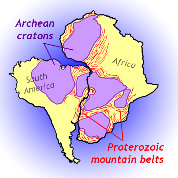
Brazil-Africa geological match shows identical rock types, ages, and structural trends across Atlantic
Ghana gold deposits align with Brazilian plateau formations when continents fitted together
Appalachian-Caledonian connection links North American and European mountain systems
Matching proves continents shared same geological history before separation
Geological Correlation Method
Geological structure matching compares rock types, ages, mineral deposits, and structural trends across ocean basins. When identical formations align perfectly after removing oceanic crust, it provides strong evidence that continents were once joined and shared the same geological processes.
Major Trans-Atlantic Matches
Geological Feature | Location 1 | Location 2 | Evidence Type | Age (Million Years) |
|---|---|---|---|---|
Precambrian Shields | Brazilian Highlands (eastern) | West African Craton | Identical rock types & ages | 2000+ million |
Gold-bearing Formations | Brazilian Plateau | Ghana (West Africa) | Same mineralization patterns | 2000+ million |
Appalachian-Caledonian Belt | Eastern North America | Scotland & Scandinavia | Continuous mountain system | 400-500 million |
Cape Fold Mountains | South Africa | Sierra de la Ventana (Argentina) | Similar folding patterns | 280 million |
Karoo-Paraná Basins | Southern Africa | South America | Identical sedimentary sequences | 180-280 million |
Brazil-Africa Connection Details
Eastern Brazilian coast shows Precambrian crystalline rocks that match perfectly with West African craton formations
Gold deposits in Ghana trace back to Minas Gerais region of Brazil - same Archean greenstone belts
Structural trends of Brazilian highlands continue seamlessly into African geological formations
Diamond-bearing kimberlites in both regions show similar ages and formation processes
Continental Fit
Source: Geosciences LibreTexts — 22.2: Continental drift - Geosciences LibreTexts · geo.libretexts.org
How Geological Matching Works
%%{init: {"flowchart": {"wrappingWidth": 460}}}%%
flowchart TD
  s1["`****Map geological formations** on both continents**
Identify rock types, ages, structures, and mineral deposits`"]
  s2["`****Remove oceanic crust** conceptually**
Fit continental margins together as they were before seafloor spreading`"]
  s3["`****Compare aligned formations****
Check if rock types, structural trends, and ages match across the join`"]
  s4["`****Analyze continuity****
Look for seamless continuation of geological processes and formations`"]
  s1 --> s2
  s2 --> s3
s3 --> s4Trap: Ghana gold comes from Brazilian plateau formations, not Brazilian coast (though the coastal rocks also match)
Trap: Focus on western Africa matching eastern Brazil - not the reverse or other combinations
Trap: Geological matching works for Precambrian rocks (very old) - these preserve original continental connections
Trap: Don't confuse geological structure matching with continental shelf matching (both are evidence but different types)