Consider the following statements: I. Anadyr in Siberia and Nome in Alaska are a few kilometers from each other, but when people are waking up and getting set for breakfast in these cities, it would be different days. II. When it is Monday in Anadyr, it is Tuesday in Nome. Which of the statements given above is/are correct?
Contents12
- AI only
- BII only
- CBoth I and II
- DNeither I nor II
Show answer
Answer: (A) I only
(I) 'Anadyr and Nome experience different days at breakfast time' — CORRECT.
Anadyr (in Chukotka, Russia) and Nome (in Alaska, USA) are geographically close — separated by only about 600 km across the Bering Strait.
However, the International Date Line (IDL) runs between them.
This means that when it's breakfast time (say 8 AM) on a Monday in Anadyr, it would be breakfast time on SUNDAY in Nome — a completely different calendar day, even though the physical distance is small and both are having breakfast simultaneously. ✓
(II) 'When it is Monday in Anadyr, it is Tuesday in Nome' — INCORRECT.
This gets the direction wrong.
Anadyr is WEST of the IDL (on the Asian side, which is always a day AHEAD).
Nome is EAST of the IDL (on the American side, which is a day BEHIND).
So if it's Monday in Anadyr, it's SUNDAY in Nome — not Tuesday.
Think of it this way: when you cross the IDL going from west to east (Asia to Americas), you go BACK one day. ✗
Only Statement I is correct. Answer is (a).
The International Date Line runs through the Bering Strait between Russia and Alaska, creating the world's largest time difference (up to 21 hours) across the shortest geographic distance.
UPSC is testing whether students understand that crossing the International Date Line changes the calendar day, not just the clock time - a concept many confuse with regular time zone changes.
International Date Line
Geography International Date Line Anadyr Nome different days
International Date Line: Location, Function & UPSC Traps
IDL runs roughly along 180° longitude through the Pacific Ocean
Crossing IDL west to east means going back one day (lose a day)
Crossing IDL east to west means going forward one day (gain a day)
IDL zigzags to keep countries on the same side as their territories
The International Date Line (IDL) is an imaginary line that determines where each calendar day begins and ends on Earth. Unlike time zone boundaries that only change the hour, crossing the IDL changes the calendar date itself.
IDL Crossing Effects
Direction of Travel | Date Change | Example | Memory Aid |
|---|---|---|---|
West to East (Asia → Americas) | Lose one day (go back) | Monday → Sunday | West to East = Wipe Earlier day |
East to West (Americas → Asia) | Gain one day (go forward) | Sunday → Monday | East to West = Earn Whole new day |
IDL Path & Deviations
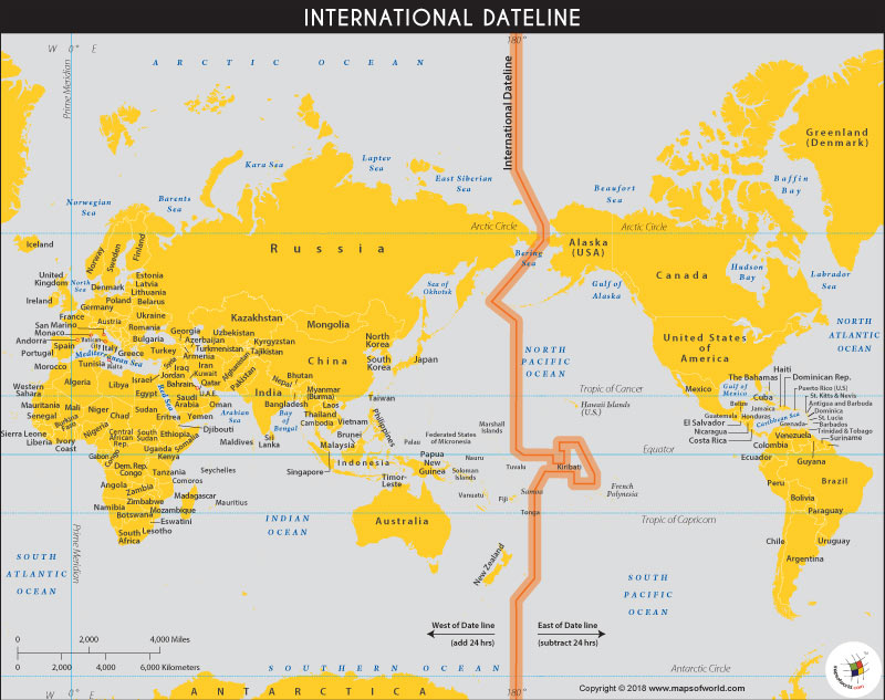
Source: World Map — What is the International Date Line? - Geographic Insights · www.mapsofworld.com
Key IDL Deviations
Russia (Chukotka) including Anadyr is west of IDL - always one day ahead of Alaska
Alaska including Nome is east of IDL - always one day behind Chukotka
Kiribati moved entirely west of IDL in 1995 to unify all its islands
Samoa jumped west of IDL in 2011, skipping December 30th entirely
This explains why Anadyr and Nome, despite being only 600 km apart across the Bering Strait, experience different calendar days simultaneously. When both cities have breakfast at 8 AM local time, Anadyr (west of IDL) is one day ahead of Nome (east of IDL).
Trap: Confusing IDL direction - remember Asia is always ahead, Americas are behind
Trap: Statement II reverses the relationship - if Monday in Anadyr, it's Sunday in Nome, not Tuesday
Trap: Thinking physical proximity means same date - IDL creates date difference regardless of distance
Common Error: Mixing up 'gain/lose day' with 'ahead/behind' - use consistent directional thinking
Anadyr-Nome Geographic Context
Geography Anadyr Nome Siberia Alaska Bering Strait
Anadyr & Nome: Geographic Proximity Across IDL
Anadyr is the capital of Chukotka Peninsula, easternmost Russia
Nome is a city in western Alaska, closest US point to Russia
Separated by only ~600 km across the Bering Strait
Both cities are in Arctic/Subarctic climate zones
Anadyr vs Nome Comparison
City | Country/Region | Position relative to IDL | Time Zone | Significance |
|---|---|---|---|---|
Anadyr | Russia (Chukotka) | West of IDL | UTC +12 | Easternmost Russian city |
Nome | USA (Alaska) | East of IDL | UTC -9 | Historic gold rush town, closest to Russia |
Bering Strait Region
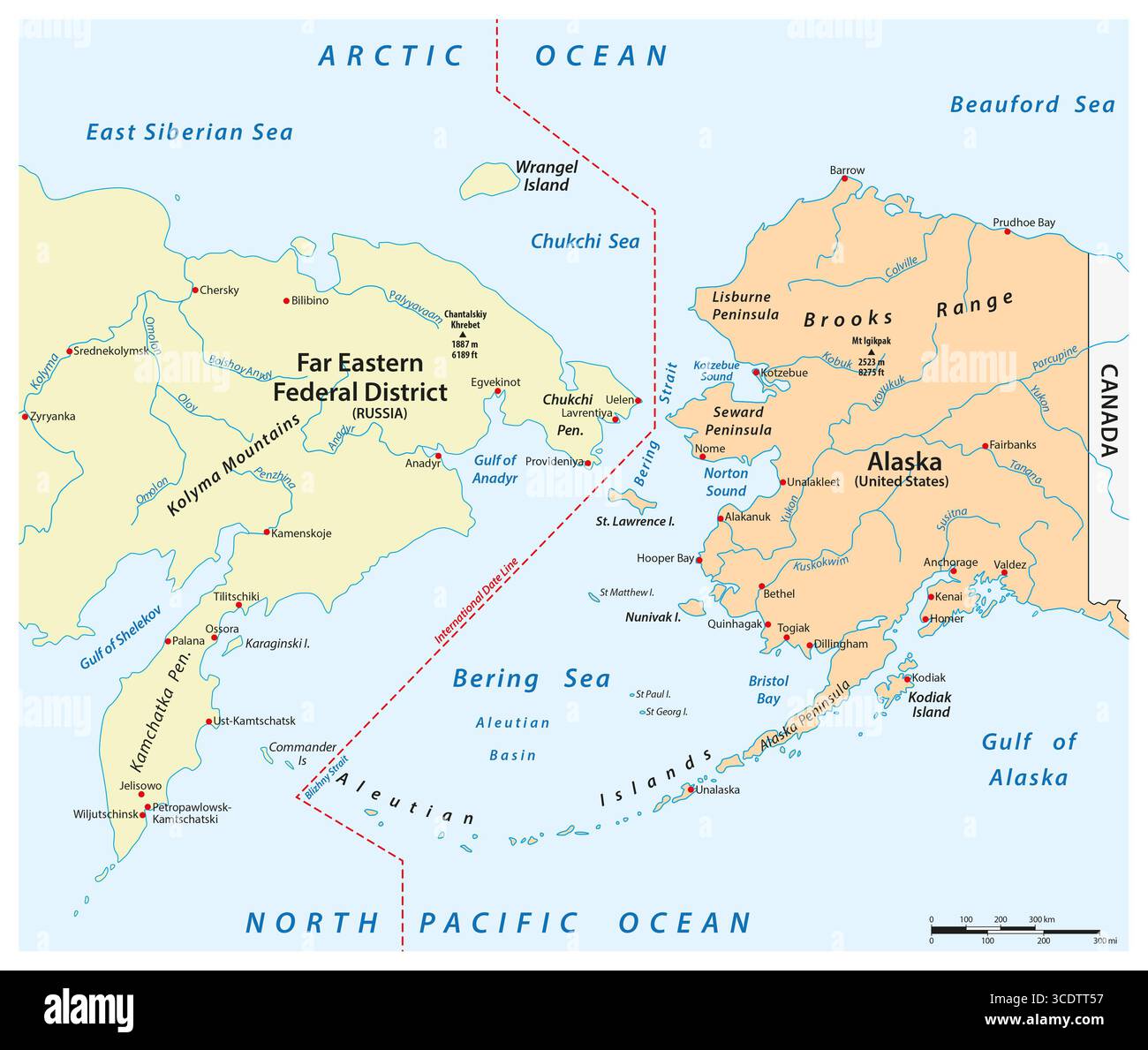
Source: Alamy — Bering strait hi-res stock photography and images - Alamy · www.alamy.com
Strategic Importance
Bering Strait is the narrowest point between Asia and North America
Nome was a major gold rush destination in early 1900s
Anadyr serves as administrative center for Russia's Chukotka Autonomous Region
Both cities demonstrate how political boundaries (IDL) can create dramatic time differences despite geographic proximity
Trap: Assuming geographic proximity means similar time zones - these cities have 21-hour difference
Memory Aid: Anadyr = Asia (ahead), Nome = North America (behind)
Time Zones & Date Changes
Geography breakfast time different days Monday Tuesday
Time Zone Mechanics: How Date Changes Work Globally
Earth has 24 time zones, each roughly 15° longitude wide
GMT/UTC at 0° longitude is the global time reference
Moving east from GMT = positive time zones (ahead)
Moving west from GMT = negative time zones (behind)
Time zones exist because Earth rotates 15° per hour. When the sun rises in one location, it's still dark 15° to the west. The International Date Line at 180° longitude is where the calendar date changes - it's the opposite side of Earth from the Prime Meridian at Greenwich.
Date Change Process
%%{init: {"flowchart": {"wrappingWidth": 460}}}%%
flowchart TD
  s1["`**New Day Begins**
Each new **calendar day** starts at **IDL** (180° longitude)`"]
  s2["`**Westward Progression**
Day moves **westward** across Pacific islands, Asia, Europe`"]
  s3["`**Reaches Americas**
Day crosses **IDL again** to reach Americas **last**`"]
  s4["`**24-Hour Cycle**
Full day completes when it returns to **starting point at IDL**`"]
  s1 --> s2
  s2 --> s3
  s3 --> s4
Extreme Time Zone Examples
Location Pair | Distance | Time Difference | Date Difference | Reason |
|---|---|---|---|---|
Anadyr-Nome | ~600 km | 21 hours | 1 day apart | IDL separation |
Samoa-American Samoa | ~100 km | 24 hours | 1 day apart | IDL passes between |
Big Diomede-Little Diomede | 4 km | 20 hours | 1 day apart | Russia-USA IDL boundary |
Time Zone Anomalies
China uses only one time zone despite spanning 5 theoretical zones
India uses UTC +5:30 - a 30-minute offset from standard hour zones
Russia spans 11 time zones - the most of any country
Some countries skip days when moving across IDL (Samoa skipped Dec 30, 2011)
Trap: Confusing 'ahead in time' with 'east geographically' - Asia is ahead, Americas behind
Trap: Thinking same local time = same date - IDL creates date differences at same hour
Memory: When it's breakfast Monday in Asia, it's breakfast Sunday in nearby America