In which of the following activities are Indian Remote Sensing (IRS) satellites used? 1. Assessment of crop productivity 2. Locating groundwater resources 3. Mineral exploration 4. Telecommunications 5. Traffic studies Select the correct answer using the code given below.
Contents16
- A1, 2 and 3 only
- B4 and 5 only
- C1 and 2 only
- D1, 2, 3, 4 and 5
Show answer
Answer: (A) 1, 2 and 3 only
India's space programme has TWO main satellite systems with different purposes.
(1) INSAT (Indian National Satellite System) — geostationary satellites used for TELECOMMUNICATIONS, television broadcasting, and meteorological services.
(2) IRS (Indian Remote Sensing) — polar sun-synchronous orbit satellites used for EARTH OBSERVATION and natural resource management.
IRS satellites carry cameras and sensors that capture images of the Earth's surface, which are used for:
Crop productivity assessment (Statement 1) — YES. IRS data helps estimate crop area, crop health (using vegetation indices like NDVI), and predict yields. This is used by the Ministry of Agriculture for food security planning.
Locating groundwater resources (Statement 2) — YES. IRS satellites help identify geological features like lineaments, faults, and rock types that indicate potential groundwater zones. This information helps plan wells and borewells.
Mineral exploration (Statement 3) — YES. Satellite imagery helps identify geological formations, rock types, and mineral-bearing zones. ISRO's Geological Applications Programme supports the mining and exploration industry.
Telecommunications (Statement 4) — NO. This is the job of INSAT/GSAT communication satellites, NOT IRS satellites. IRS satellites observe the Earth; they do not relay communication signals.
Traffic studies (Statement 5) — NO. While satellite imagery can show roads and urban patterns, traffic monitoring in real-time is not a primary function of IRS satellites.
Answer: 1, 2 and 3 only.
India operates two distinct satellite systems: IRS satellites for Earth observation and resource mapping, and INSAT satellites for telecommunications and broadcasting.
The question tests whether students can distinguish between remote sensing satellites (which observe Earth) and communication satellites (which relay signals).
Indian Remote Sensing (IRS) Satellites
Science And Technology IRS Indian Remote Sensing
IRS Satellites: Applications & UPSC Exam Focus
IRS satellites are polar sun-synchronous orbit satellites for Earth observation
Primary uses: crop assessment, groundwater detection, mineral exploration
IRS satellites do NOT handle telecommunications or real-time traffic monitoring
First IRS satellite launched in 1988
What IRS Does
IRS (Indian Remote Sensing) satellites are Earth observation satellites that capture detailed images of land, water, and vegetation using cameras and sensors. They orbit in polar sun-synchronous paths, covering the entire Earth systematically.
IRS Applications
Application | How It Works | Ministry/Agency Using It | UPSC Status |
|---|---|---|---|
Crop Productivity Assessment | NDVI and vegetation indices measure crop health | Ministry of Agriculture | ✓ Tested |
Groundwater Detection | Identifies lineaments & faults indicating water zones | Central Ground Water Board | ✓ Tested |
Mineral Exploration | Maps geological formations and rock types | Geological Survey of India | ✓ Tested |
Forest Monitoring | Tracks deforestation and forest cover changes | Forest Survey of India | Often tested |
Disaster Management | Flood mapping, cyclone tracking, drought assessment | NDMA | Frequently tested |
IRS Satellite Imagery

Source: Cropler — How Satellite Images Are Converted Into NDVI · www.cropler.io
Trap: IRS satellites do NOT handle telecommunications - that's INSAT's job
Trap: Traffic studies are NOT a primary IRS function - real-time monitoring needs different technology
Confusion: Don't mix IRS (Earth observation) with INSAT (communication + weather)
Memory aid: IRS = Imaging Remote Sensing, INSAT = Indian National SATellite for communication
INSAT Communication Satellites
Science And Technology INSAT telecommunications
INSAT System: Communication & Weather Satellites
INSAT satellites are geostationary satellites for communication and weather
Functions: telecommunications, TV broadcasting, meteorological services
Positioned at 36,000 km above equator in fixed positions
Modern series called GSAT (Geostationary Satellite)
INSAT Purpose
INSAT (Indian National Satellite System) provides telecommunications, television broadcasting, and weather monitoring services. Unlike IRS satellites that observe Earth, INSAT satellites act as relay stations in space.
IRS vs INSAT Comparison
Feature | IRS Satellites | INSAT Satellites |
|---|---|---|
Primary Function | Earth observation & imaging | Communication & broadcasting |
Orbit Type | Polar sun-synchronous | Geostationary |
Altitude | 700-900 km | 36,000 km |
Key Applications | Crop monitoring, mineral exploration | Telecommunications, TV, weather |
Movement | Orbits around Earth | Fixed above one location |
UPSC Confusion | Does NOT do telecommunications | Does NOT do detailed Earth imaging |
INSAT Applications
# INSAT System
## Telecommunications
- Mobile networks
- Internet connectivity
- Rural telephony
- VSAT services
## Broadcasting
- Television
- Radio
- DTH services
- Educational programs
## Meteorology
- Weather forecasting
- Cyclone tracking
- Climate monitoring
- Early warningsKey Distinction: INSAT = communication, IRS = observation
Trap: Don't assume all Indian satellites do everything - each system has specific roles
UPSC Pattern: Questions often test which satellite system does what function
Satellite Orbits & Applications
Science And Technology polar sun-synchronous orbit geostationary
Satellite Orbits: Why Different Orbits Serve Different Purposes
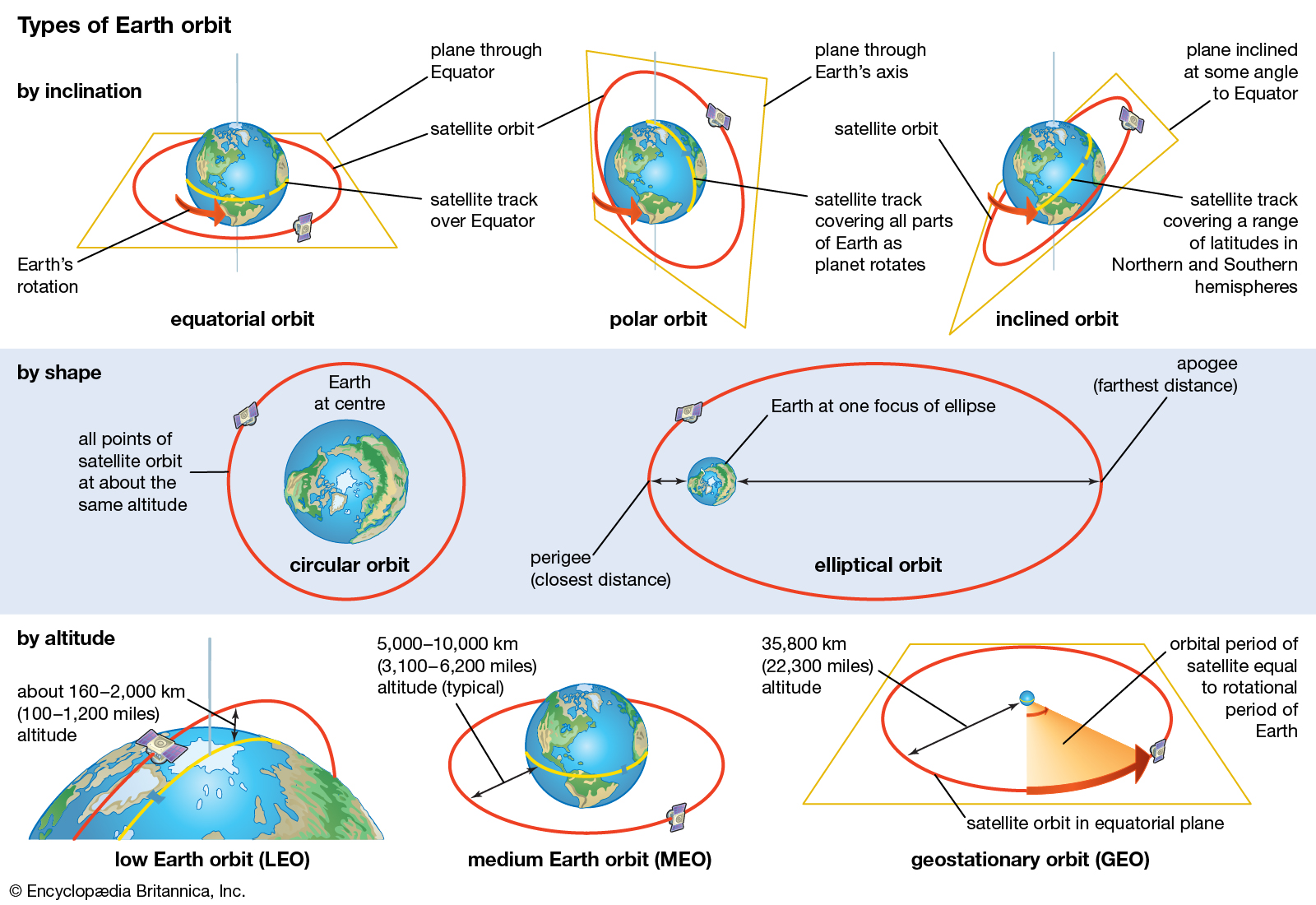
Geostationary orbit: Fixed position at 36,000 km for communication
Polar sun-synchronous: Lower orbit 700-900 km for Earth observation
Orbit determines satellite's function and coverage
Why Orbit Matters
The orbital path determines what a satellite can do. Geostationary satellites stay fixed above one location for continuous communication coverage. Polar-orbiting satellites circle the Earth to capture images of every location.
Orbit Types & Uses
Orbit Type | Altitude | Movement | Best For | Indian Examples |
|---|---|---|---|---|
Geostationary (GEO) | 36,000 km | Matches Earth's rotation - stays fixed | Communication, TV, weather monitoring | INSAT, GSAT |
Polar Sun-Synchronous | 700-900 km | Passes over poles, covers whole Earth | Earth observation, imaging, mapping | IRS, Cartosat |
Low Earth Orbit (LEO) | 200-2000 km | Fast orbit around Earth | Navigation, scientific missions | IRNSS navigation |
Satellite Orbit Diagram
Source: IAS Gyan — Types of Earth Orbits · www.iasgyan.in
Physics Logic: Higher orbit = slower movement = good for fixed communication
Physics Logic: Lower polar orbit = faster coverage = good for imaging entire Earth
UPSC Tests: Which orbit type is used for which application
Remote Sensing in Natural Resources
Science And Technology crop productivity groundwater resources mineral exploration
How Remote Sensing Detects Crops, Water & Minerals
NDVI (Normalized Difference Vegetation Index) measures crop health
Lineaments and faults in satellite images indicate groundwater zones
Geological formations visible from space help locate minerals
Multispectral sensors capture light beyond human vision
Remote Sensing Principles
Satellites use multispectral cameras that capture light in different wavelengths. Healthy vegetation reflects infrared light differently than stressed crops. Rock types have unique spectral signatures. Water-bearing zones create linear patterns visible from space.
Crop Assessment Process
%%{init: {"flowchart": {"wrappingWidth": 460}}}%%
flowchart TD
  s1["`**Satellite captures multispectral images**
IRS sensors record visible and infrared light reflected by crops`"]
  s2["`**Calculate NDVI values**
**NDVI = (NIR - Red) / (NIR + Red)** formula shows vegetation health`"]
  s3["`**Map crop health zones**
High NDVI = healthy crops, Low NDVI = stressed/diseased crops`"]
  s4["`**Estimate productivity**
Correlate NDVI with expected yield for food security planning`"]
  s1 --> s2
  s2 --> s3
  s3 --> s4
Detection Methods
Resource | What Satellites Detect | Technical Method | Ground Truth |
|---|---|---|---|
Healthy Crops | High infrared reflection | NDVI > 0.6 | Green, dense vegetation |
Stressed Crops | Low infrared reflection | NDVI < 0.3 | Yellow, sparse vegetation |
Groundwater Zones | Linear geological features | Lineament mapping | Fractures in rocks allow water flow |
Mineral Deposits | Unique spectral signatures | Geological mapping | Different rocks reflect light differently |
Technical Detail: NDVI is the key index for crop monitoring - remember this acronym
Groundwater Logic: Satellites don't see water directly - they see rock fractures where water collects
Mineral Logic: Satellites identify rock types, not minerals directly underground