Which one the following countries has its own Satellite Navigation System?
Contents10
- AAustralia
- BCanada
- CIsrael
- DJapan
Show answer
Answer: (D) Japan
Among the options,
France is part of the European Union which operates the Galileo satellite navigation system.
The US has GPS,
Russia has GLONASS,
and China has BeiDou.
India has NavIC and Japan has QZSS (both regional systems).
Answer is (d) France.
Japan operates QZSS (Quasi-Zenith Satellite System), a regional satellite navigation system that provides enhanced GPS accuracy over the Asia-Oceania region.
Only a few countries have developed independent satellite navigation systems - the US (GPS), Russia (GLONASS), China (BeiDou), EU (Galileo), India (NavIC), and Japan (QZSS).
The question tests knowledge of which countries have achieved satellite navigation capability, a key indicator of advanced space technology and strategic autonomy.
Global Satellite Navigation Systems
Science And Technology Satellite Navigation System
Global Satellite Navigation Systems: Complete UPSC Guide
Japan has QZSS (Quasi-Zenith Satellite System) - regional navigation system
6 operational GNSS: GPS (US), GLONASS (Russia), BeiDou (China), Galileo (EU), NavIC (India), QZSS (Japan)
Australia, Canada, Israel do not have independent navigation systems
Regional systems like NavIC and QZSS provide enhanced accuracy in specific regions
Satellite navigation systems use constellation of satellites to provide precise location and timing services globally or regionally. Only a few countries have developed independent systems due to strategic importance and high costs.
Major Navigation Systems
System | Country/Region | Type | Satellites | Status |
|---|---|---|---|---|
GPS | United States | Global | ~30 | Fully operational since 1995 |
GLONASS | Russia | Global | ~24 | Fully operational |
BeiDou | China | Global | ~35 | Global coverage since 2020 |
Galileo | European Union | Global | ~30 | Operational since 2016 |
NavIC | India | Regional | 7 | Covers India + 1,500 km |
QZSS | Japan | Regional | 4+ | Enhances GPS in Asia-Pacific |
Regional vs Global Systems
NavIC covers India and surrounding region up to 1,500 km from Indian boundary
QZSS primarily serves Asia-Pacific region with enhanced accuracy for Japan
Regional systems work in conjunction with global systems for better precision
Dual-use technology: civilian applications like navigation, military applications like precision targeting
Global Coverage
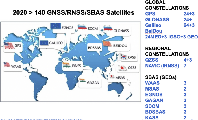
Source: Springer Nature — Status, perspectives and trends of satellite navigation ... · link.springer.com
Trap: Australia, Canada rely on GPS - they don't have independent systems
Trap: Israel has advanced space program but no navigation system
Confusion: QZSS enhances GPS accuracy but is Japan's independent regional system
Remember: Only 6 countries/regions have operational navigation systems globally
India's NavIC System
Science And Technology
NavIC (IRNSS): India's Regional Navigation System
NavIC = Navigation with Indian Constellation, developed by ISRO
7 satellites: 3 geostationary + 4 geosynchronous orbit
Coverage: India + 1,500 km surrounding region
Accuracy: Better than 20 meters in primary service area
NavIC (Navigation with Indian Constellation) is India's independent regional satellite navigation system developed by ISRO. Originally called IRNSS (Indian Regional Navigation Satellite System), it provides strategic autonomy from foreign systems.
NavIC Constellation
Satellite | Orbit Type | Launch Year | Status |
|---|---|---|---|
IRNSS-1A | Geosynchronous | 2013 | Operational |
IRNSS-1B | Geosynchronous | 2014 | Operational |
IRNSS-1C | Geosynchronous | 2014 | Operational |
IRNSS-1D | Geosynchronous | 2015 | Operational |
IRNSS-1E | Geosynchronous | 2015 | Operational |
IRNSS-1F | Geostationary | 2016 | Operational |
IRNSS-1G | Geostationary | 2016 | Operational |
Strategic Importance
Military applications: Precision targeting, troop movement, border surveillance
Civilian uses: Navigation, disaster management, vehicle tracking, surveying
Strategic autonomy: Reduces dependence on GPS during conflicts
Make in India: Indigenous technology development and space sector growth
Name change: Originally IRNSS, renamed NavIC in 2016
Regional system: Covers India + surrounding areas, not global
ISRO achievement: India is 5th country/region with navigation system
Countries Without Independent Navigation Systems
Science And Technology Australia Canada Israel
Why Some Advanced Countries Lack Independent Navigation Systems
Australia, Canada, Israel have advanced space programs but no independent navigation systems
These countries rely on GPS and other existing systems
Cost and strategic partnerships make independent systems unnecessary for them
Space Capabilities vs Navigation Systems
Country | Space Agency | Launch Capability | Navigation System | Reason |
|---|---|---|---|---|
Australia | Australian Space Agency | Limited | Uses GPS | Strong US alliance, cost factors |
Canada | Canadian Space Agency | Partners with others | Uses GPS | NAFTA partner, GPS access |
Israel | Israel Space Agency | Independent launches | Uses GPS | US strategic partner, regional focus |
Japan | JAXA | Independent launches | QZSS + GPS | Regional security needs |
India | ISRO | Independent launches | NavIC | Strategic autonomy priority |
Why No Independent Systems
High costs: Developing navigation systems requires billions of dollars investment
Strategic partnerships: Close allies get guaranteed GPS access even during conflicts
Technical complexity: Requires 20+ satellites for global coverage, advanced ground infrastructure
Regional focus: Some countries prioritize other space applications over navigation
Don't confuse: Advanced space program ≠ navigation system (Israel launches satellites but uses GPS)
Australia trap: Has space agency and launches but no independent navigation
Canada mistake: Strong space industry but relies completely on US GPS