Consider the following pairs :
Contents17
Consider the following pairs :
| Peak | Mountains | |
|---|---|---|
| 1. | Namcha Barwa | Garhwal Himalaya |
| 2. | Nanda Devi | Kumaon Himalaya |
| 3. | Nokrek | Sikkim Himalaya |
Which of the pairs given above is/are correctly matched?
- A1 and 2
- B2 only
- C1 and 3
- D3 only
Show answer
Answer: (B) 2 only
The answer is (B) Only Pair 2 is correct.
Pair 1 is WRONG:
Namcha Barwa is in Tibet (far eastern Himalayas), NOT in Garhwal Himalaya (which is in Uttarakhand).
Pair 2 is CORRECT:
Nanda Devi (India's 2nd highest peak, 7,817m) is in the Kumaon Himalayas, Chamoli district, Uttarakhand.
Pair 3 is WRONG:
Nokrek Peak is the highest peak of Garo Hills in MEGHALAYA, NOT Sikkim Himalaya. Sikkim has peaks like Kangchenjunga — totally different region.
Tip:
These "match the pairs" questions often rely on you confusing eastern and western Himalayan features.
Nanda Devi is India's second highest peak at 7,817 meters and lies in Uttarakhand's Kumaon Himalayas.
UPSC is testing whether students can distinguish between different Himalayan ranges (Garhwal, Kumaon, Sikkim) and avoid confusing peaks from completely different mountain systems like Meghalaya's Garo Hills.
The question checks knowledge of specific peak locations across India's diverse mountain ranges, from the main Himalayas to northeastern hill ranges.
Himalayan Regional Divisions
Geography Garhwal Himalaya Kumaon Himalaya Sikkim Himalaya
Himalayan Regional Divisions: West to East Classification
Himalayas are divided into 5 longitudinal regions from west to east
Kumaon Himalaya lies in Uttarakhand between rivers Kali and Sutlej
Garhwal Himalaya is in western Uttarakhand, west of river Kali
Sikkim Himalaya is a separate eastern section in Sikkim state
Regional Framework
The Himalayan mountain system extends over 2,500 km and is traditionally divided into longitudinal sections based on river valleys and political boundaries. Each section has distinct geological features and major peaks.
West to East Divisions
Region | Location | Key Rivers | States/Countries | Major Features |
|---|---|---|---|---|
Kashmir Himalaya | Westernmost | Indus, Jhelum | J&K, PoK | Nanga Parbat, K2 |
Himachal Himalaya | West-Central | Sutlej, Beas, Ravi | Himachal Pradesh | Dhauladhar, Pir Panjal ranges |
Garhwal Himalaya | West of River Kali | Yamuna, Ganga | Western Uttarakhand | Gangotri, Kedarnath peaks |
Kumaon Himalaya | Between Kali-Teesta | Kali, Ghaghara | Eastern Uttarakhand | Nanda Devi, Pindari glacier |
Nepal Himalaya | Central Section | Karnali, Gandaki | Nepal | Mount Everest, Annapurna |
Sikkim Himalaya | Between Teesta-Dihang | Teesta | Sikkim, Darjeeling | Kangchenjunga |
Arunachal Himalaya | Easternmost | Dihang, Lohit | Arunachal Pradesh | Namcha Barwa (Tibet side) |
Regional Map
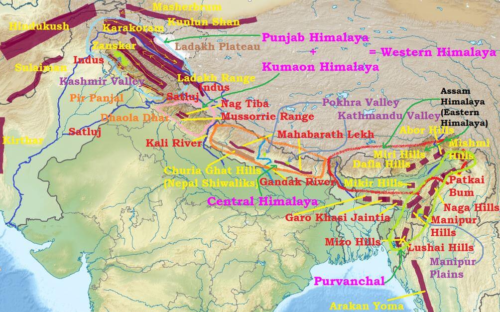
Source: PMF IAS — Regional Divisions of Indian Himalayas - PMF IAS · www.pmfias.com
Trap: Namcha Barwa is in Tibet/Arunachal border, NOT Garhwal - students confuse eastern vs western peaks
Trap: Nokrek Peak is in Meghalaya Garo Hills, NOT Sikkim Himalayas - completely different mountain system
Trap: Both Garhwal and Kumaon are in Uttarakhand but are separate Himalayan sections
Trap: River Kali divides Garhwal (west) from Kumaon (east) within Uttarakhand
Major Himalayan Peaks
Geography Namcha Barwa Nanda Devi Peak
Major Himalayan Peaks: Heights & Regional Location
Nanda Devi (7,817m) is India's 2nd highest peak in Kumaon Himalayas
Namcha Barwa (7,782m) lies on Tibet-Arunachal border, not in Garhwal
Kangchenjunga (8,586m) is world's 3rd highest, located in Sikkim Himalayas
Peak Classification
Himalayan peaks above 7,000m are distributed across different regional sections. Location matters more than height for UPSC - knowing which peak belongs to which Himalayan division is frequently tested.
Key Peaks by Region
Peak Name | Height (m) | Himalayan Region | State/Country | Significance |
|---|---|---|---|---|
Mount Everest | 8,849 | Nepal Himalaya | Nepal-Tibet border | World's highest peak |
Kangchenjunga | 8,586 | Sikkim Himalaya | Sikkim-Nepal border | India's highest, world's 3rd |
Nanda Devi | 7,817 | Kumaon Himalaya | Uttarakhand (Chamoli) | India's 2nd highest |
Namcha Barwa | 7,782 | Arunachal Himalaya | Tibet-Arunachal border | Eastern anchor of Himalayas |
Kamet | 7,756 | Garhwal Himalaya | Uttarakhand | Garhwal's highest peak |
Nanga Parbat | 8,126 | Kashmir Himalaya | PoK | Western anchor, 'Killer Mountain' |
Peak Locations - Quick Facts
Nanda Devi lies in Chamoli district, Uttarakhand - part of Nanda Devi Biosphere Reserve
Namcha Barwa marks the eastern syntaxial bend where Himalayas curve south into Myanmar ranges
Trishul (7,120m) is another major Kumaon Himalaya peak near Nanda Devi
Most 8,000m+ peaks lie in Nepal and Karakoram (Pakistan), not Indian Himalayas
Trap: Nanda Devi is 2nd highest in India but students often think it's the highest (that's Kangchenjunga)
Trap: Namcha Barwa sounds Indian but is actually on Tibet side of border
Trap: Don't confuse Garhwal peaks (Kamet, Kedarnath) with Kumaon peaks (Nanda Devi, Trishul)
Trap: Peak heights change slightly in different sources - focus on regional location for UPSC
Nokrek Peak & Garo Hills
Geography Nokrek
Nokrek Peak: Highest Point of Garo Hills, Meghalaya
Nokrek Peak (1,412m) is the highest point of Garo Hills in Meghalaya
NOT part of Himalayas - belongs to Meghalaya Plateau (ancient landmass)
Located in Nokrek National Park, part of Nokrek Biosphere Reserve
Geographic Context
Nokrek Peak is part of the Meghalaya Plateau, which is an ancient block of the peninsular India, not the young-fold Himalayan system. This distinction is crucial for UPSC questions that test regional classification.
Meghalaya Hill Ranges
Hill Range | Highest Peak | Height (m) | District | Key Features |
|---|---|---|---|---|
Garo Hills | Nokrek Peak | 1,412 | West Garo Hills | Nokrek Biosphere Reserve, citrus cultivation |
Khasi Hills | Shillong Peak | 1,965 | East Khasi Hills | Shillong city, wettest region |
Jaintia Hills | Lum Symper | 1,350 | West Jaintia Hills | Coal mining, limestone caves |
Nokrek Biosphere Details
Nokrek Biosphere Reserve (1988) covers 820 sq km in West Garo Hills district
Famous for wild citrus (Citrus indica) - ancestor of modern citrus fruits
Part of UNESCO MAB Programme since 2009
Home to Asian elephants, hoolock gibbons, and red pandas
Location Map
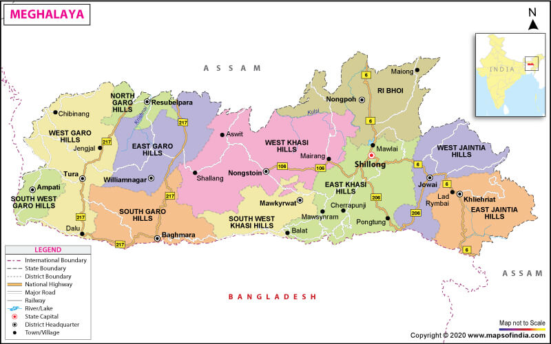
Source: India Map — What are the Key Facts of Meghalaya? | Meghalaya Facts - Answers · www.mapsofindia.com
Major Trap: Nokrek is in Meghalaya, NOT Sikkim - students confuse northeastern hill states
Trap: Nokrek is part of peninsular plateau, NOT young-fold Himalayas
Trap: Don't confuse Garo Hills (Meghalaya) with Garhwal Himalayas (Uttarakhand) - similar names
Sikkim Himalaya Major Peaks
Geography Sikkim Himalaya
Sikkim Himalaya: Kangchenjunga & Eastern Himalayan Features
Kangchenjunga (8,586m) is the highest peak in Sikkim Himalayas
Sikkim Himalayas lie between Teesta and Dihang rivers
Region includes parts of Sikkim, Darjeeling, and eastern Nepal
Regional Boundaries
The Sikkim Himalaya section extends from River Teesta in the west to River Dihang in the east. Kangchenjunga massif dominates this region, forming the India-Nepal border.
Major Peaks in Sikkim Himalayas
Peak Name | Height (m) | Location | Significance |
|---|---|---|---|
Kangchenjunga | 8,586 | Sikkim-Nepal border | World's 3rd highest, India's highest |
Lhotse | 8,516 | Nepal side | World's 4th highest peak |
Makalu | 8,485 | Nepal-Tibet border | World's 5th highest peak |
Cho Oyu | 8,188 | Nepal-Tibet border | World's 6th highest peak |
Kabru | 7,412 | Sikkim-Nepal border | Subsidiary peak of Kangchenjunga |
Sikkim Himalaya Features
Nathu La Pass (4,310m) connects Sikkim with Tibet - historic Silk Route point
Zemu Glacier is the largest glacier in eastern Himalayas, flows from Kangchenjunga
Region receives heavy monsoon rainfall making it prone to landslides
Rhododendrons are the characteristic vegetation - Sikkim has 40+ species
Trap: Kangchenjunga belongs to Sikkim Himalayas, NOT Nokrek which is in Meghalaya
Trap: Sikkim Himalayas include eastern Nepal peaks too, not just Sikkim state
Trap: Don't confuse Teesta River (Sikkim boundary) with Tista River (different spelling/region)