Which of the following is geographically closest to Great Nicobar?
Contents13
- ASumatra
- BBorneo
- CJava
- DSri Lanka
Show answer
Answer: (A) Sumatra
Great Nicobar is the southernmost and largest island of the Nicobar Islands group, which is part of India's Andaman and Nicobar Islands union territory.
It is located at the southeastern tip of the Bay of Bengal.
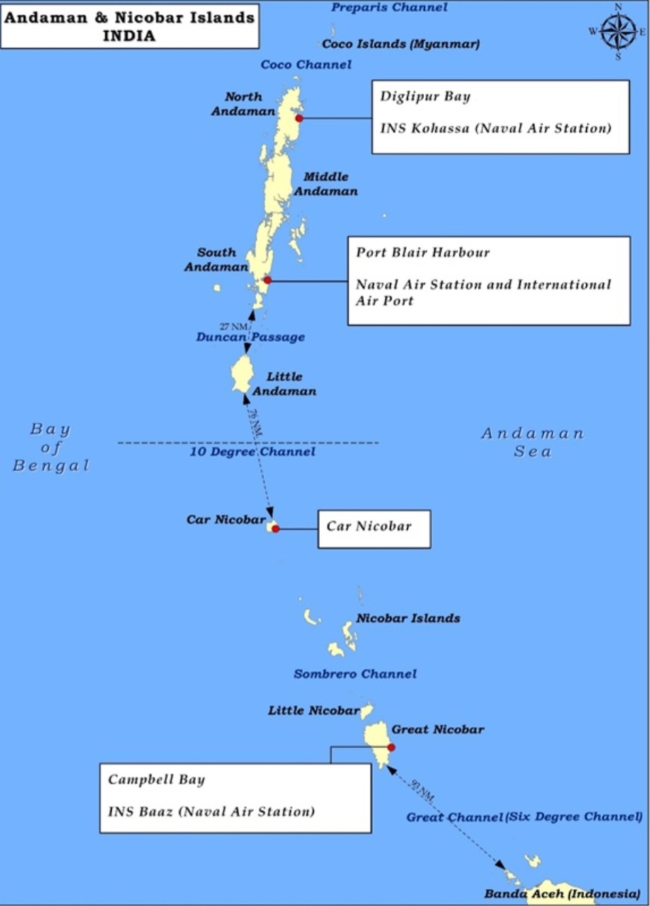
Sumatra (Indonesia) lies just about 150-180 km south of Great Nicobar, separated by the Six Degree Channel (also called the Great Channel).
This makes Sumatra by far the geographically closest among the listed options.
Borneo (shared by Malaysia, Indonesia, and Brunei) lies much further east.
Java (Indonesia) is even further south and east.
Sri Lanka is far to the west, located off the southeastern coast of India near Tamil Nadu.
This question tests basic map reading and spatial awareness of India's island territories.
A useful fact: India's southernmost point, Indira Point, is located on Great Nicobar Island, and it was severely damaged during the 2004 Indian Ocean tsunami.
The proximity of Great Nicobar to Sumatra gives it strategic significance for India's 'Look East' (now 'Act East') policy.
Great Nicobar is India's southernmost territory, located just 150-180 km from Indonesia's Sumatra across the Six Degree Channel.
The 2004 Indian Ocean tsunami severely damaged Indira Point on Great Nicobar, highlighting its proximity to the Indonesian archipelago where the tsunami originated.
This tests whether students can visualize India's eastern maritime boundaries and understand that the Andaman and Nicobar Islands extend much closer to Southeast Asia than to mainland India.
Great Nicobar Island
Geography Great Nicobar
Great Nicobar Island: Location & Strategic Importance
Southernmost and largest island of Nicobar Islands group
Contains Indira Point - India's southernmost point
Located 150-180 km north of Sumatra, Indonesia
Severely affected by 2004 Indian Ocean tsunami
Geographic Position
Great Nicobar is India's southernmost territory, located at the southeastern tip of the Bay of Bengal. It forms part of the Andaman and Nicobar Islands Union Territory and serves as India's closest point to Southeast Asia.
Key Geographic Facts
Feature | Details |
|---|---|
Location | Southeastern Bay of Bengal |
Administrative Status | Part of Andaman & Nicobar Islands UT |
Southernmost Point | Indira Point (India's southernmost tip) |
Nearest Foreign Land | Sumatra, Indonesia (150-180 km south) |
Separating Water Body | Six Degree Channel (Great Channel) |
Location Map
Source: gsdn.live — The Great Nicobar Island Development: Strategic Significance and ... · gsdn.live
Strategic Significance
Key location for India's Act East Policy - gateway to Southeast Asia
Maritime security importance in Bay of Bengal and Malacca Strait approaches
Tsunami of 2004 damaged Indira Point, reducing its height significantly
Trap: Students often think Sri Lanka is closest because it's more famous - but it's far to the west
Trap: Java and Borneo sound plausible as Indonesian islands but are much further away
Memory aid: Six Degree Channel separates Great Nicobar from Sumatra at 6°N latitude
Southeast Asian Islands
Geography Sumatra Borneo Java Sri Lanka
Major Southeast Asian Islands: Location & Countries
Sumatra - westernmost major Indonesian island, closest to India
Java - most populous Indonesian island, contains Jakarta
Borneo - world's 3rd largest island, shared by 3 countries
Sri Lanka - island nation south of India, not Southeast Asian
Island Comparison
Island | Countries | Key Cities | Distance from Great Nicobar |
|---|---|---|---|
Sumatra | Indonesia | Medan, Palembang | 150-180 km (closest) |
Java | Indonesia | Jakarta, Surabaya | ~1500 km southeast |
Borneo | Indonesia, Malaysia, Brunei | Banjarmasin, Kuching | ~2000 km east |
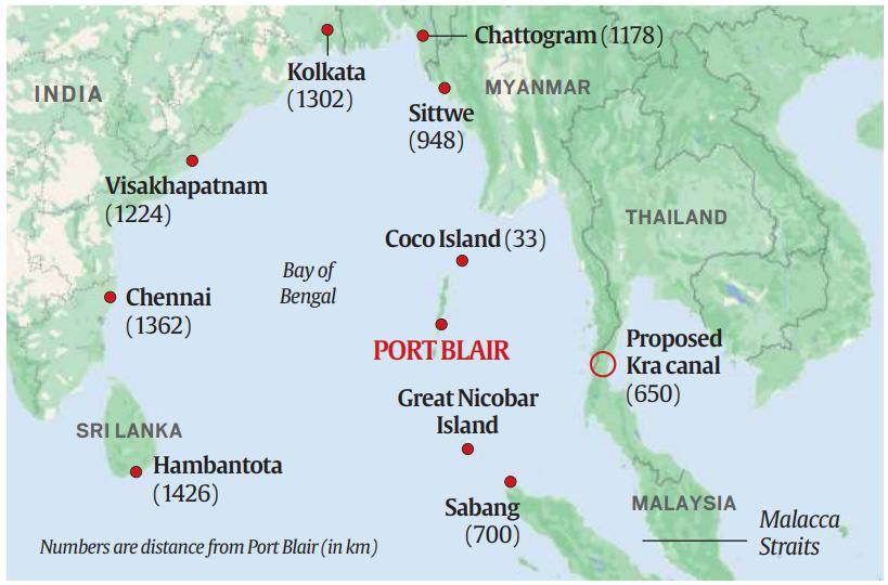
Sri Lanka | Sri Lanka | Colombo, Kandy | ~1200 km west |
Regional Map
Source: Chintan - India Foundation — Securing The Sea Lanes: The Case For Developing Great Nicobar ... · chintan.indiafoundation.in
Geographic Characteristics
Sumatra - 6th largest island globally, lies along Equator, rich in oil and palm plantations
Java - most densely populated island, over 140 million people, economic heart of Indonesia
Borneo - divided among Indonesia (Kalimantan), Malaysia (Sabah & Sarawak), and Brunei
Sri Lanka - separated from India by Palk Strait, former name Ceylon
Trap: Sri Lanka seems obvious because it's near India, but it's actually northwest of Great Nicobar
Trap: Java is Indonesia's main island but much further southeast than Sumatra
Remember: Sumatra is westernmost Indonesian island = closest to India's eastern islands
Andaman & Nicobar Islands
Geography Andaman and Nicobar Islands
Andaman & Nicobar Islands: Geography & Administration
Union Territory with capital at Port Blair
Two distinct island groups: Andaman (north) and Nicobar (south)
Strategic location in Bay of Bengal near Southeast Asia
Total area 8,249 sq km with over 570 islands
Island Groups Structure
# Andaman & Nicobar Islands UT
## Andaman Group (North)
- North Andaman
- Middle Andaman
- South Andaman
- Little Andaman
- Port Blair (capital)
## Nicobar Group (South)
- Car Nicobar
- Great Nicobar
- Little Nicobar
- Indira Point
## Key Channels
- Ten Degree Channel (between groups)
- Six Degree Channel (with Indonesia)
Important Separating Channels
Channel | Separates | Significance |
|---|---|---|
Ten Degree Channel | Andaman & Nicobar groups | At 10°N latitude |
Six Degree Channel | Nicobar & Sumatra | International boundary with Indonesia |
Nine Degree Channel | Lakshadweep islands | Between Minicoy & Maldives |
Strategic Importance
Maritime chokepoint - controls shipping lanes between Bay of Bengal and Malacca Strait
Military significance - INS Baaz naval air station on Campbell Bay (Great Nicobar)
Biodiversity hotspot - unique flora, fauna, and tribal communities
Tsunami vulnerability - severely affected in 2004, ongoing geological activity
Don't confuse: Ten Degree Channel (between Andaman-Nicobar) vs Six Degree Channel (with Indonesia)
Remember: Port Blair is in Andaman group, not Nicobar group
Trap: Nine Degree Channel is near Lakshadweep, not Andaman & Nicobar