Consider the following statements: 1. In India, the Himalayas are spread over five states only. 2. Western Ghats are spread over five states only. 3. Pulicat Lake is spread over two States only. Which of the statements given above is/are correct?
Contents15
- A1 and 2 only
- B3 only
- C2 and 3 only
- D1 and 3 only
Show answer
Answer: (B) 3 only
Statement 1 is incorrect:
The Himalayas in India spread over more than five states.
They cover Jammu & Kashmir, Himachal Pradesh, Uttarakhand, Sikkim, West Bengal (Darjeeling hills), Assam, and Arunachal Pradesh.
Some extensions of the Shiwalik range also touch Punjab and Haryana.
So saying 'five states only' is clearly wrong.
Statement 2 is incorrect:
The Western Ghats spread across six states — Gujarat, Maharashtra, Goa, Karnataka, Kerala, and Tamil Nadu — not five.
Statement 3 is correct:
Pulicat Lake, the second largest brackish water lagoon in India, lies on the border of Andhra Pradesh and Tamil Nadu (about 40% in Andhra Pradesh and 60% in Tamil Nadu).
It spreads over exactly two states.
This question requires detailed knowledge of the Atlas and careful observation of how geographical features span across state boundaries.
Since only statement 3 is correct, the answer is (b).
Pulicat Lake is India's second largest brackish water lagoon, located on the Andhra Pradesh-Tamil Nadu border with about 60% in Tamil Nadu and 40% in Andhra Pradesh.
The question tests precise knowledge of how major physical features span state boundaries - Himalayas cover seven states, Western Ghats cover six states, while Pulicat Lake spans exactly two states.
UPSC is checking if students can distinguish between approximate geographical knowledge and exact administrative boundaries of physical features.
Himalayas: State-wise Coverage
Geography Himalayas five states
Himalayas Across Indian States: Complete Coverage Map
Himalayas spread across 7+ states in India, not five
Main states: J&K, Himachal, Uttarakhand, Sikkim, West Bengal, Assam, Arunachal
Shiwalik extensions touch Punjab and Haryana
Why More Than Five
The Himalayas form India's northern mountain wall, extending from Jammu & Kashmir in the west to Arunachal Pradesh in the east. The question trap assumes students will count only major Himalayan states, but UPSC includes all states with any Himalayan presence.
State-wise Himalayan Coverage
State | Himalayan Range | Key Features |
|---|---|---|
Jammu & Kashmir | Greater Himalayas | Karakoram, highest peaks |
Himachal Pradesh | All three ranges | Complete Himalayan system |
Uttarakhand | All three ranges | Garhwal & Kumaon divisions |
Sikkim | Greater Himalayas | Kanchenjunga region |
West Bengal | Darjeeling Hills | Eastern Himalayan foothills |
Assam | Shiwalik foothills | Brahmaputra valley margins |
Arunachal Pradesh | Eastern Himalayas | Highest state coverage in NE |
Punjab | Shiwalik extensions | Minor foothill areas |
Haryana | Shiwalik extensions | Minimal coverage |
Himalayan Coverage Map
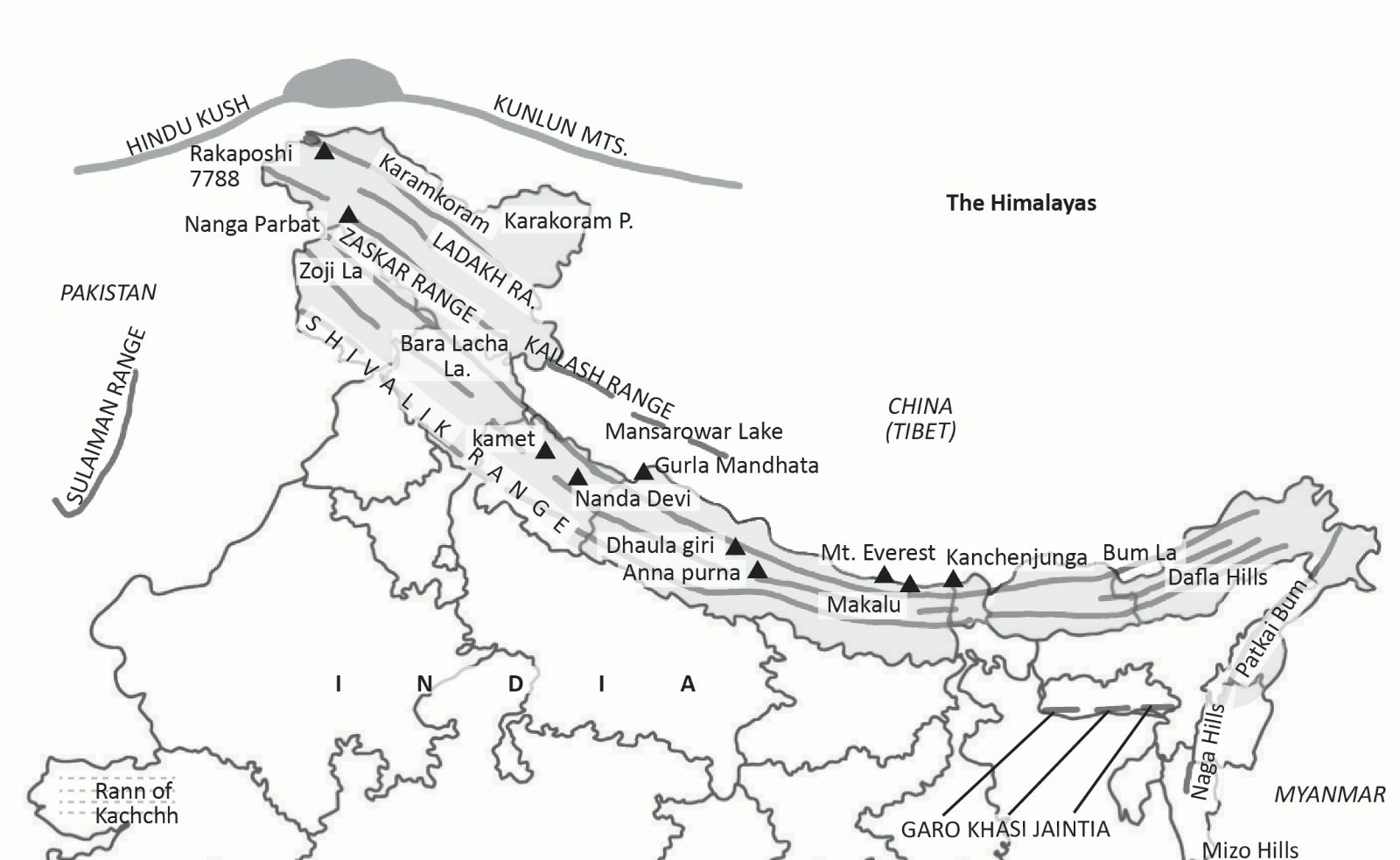
Source: StudyIQ — Himalayan Ranges of India, Map, Names, Length, Peaks · www.studyiq.com
Trap: Counting only major Himalayan states (J&K, HP, Uttarakhand, Sikkim, Arunachal) = 5, but UPSC includes West Bengal (Darjeeling) and Assam
Confusion: Forgetting that Shiwalik foothills extend into Punjab and Haryana
Memory error: Mixing up 'five states' with Western Ghats coverage
Western Ghats: Six-State Spread
Geography Western Ghats five states
Western Ghats: Complete Six-State Coverage
Western Ghats span six states: Gujarat, Maharashtra, Goa, Karnataka, Kerala, Tamil Nadu
Length: 1,600 km along western coast
UNESCO World Heritage Site and biodiversity hotspot
State-wise Western Ghats Coverage
State | Local Name | Highest Peak | Key Features |
|---|---|---|---|
Gujarat | Sahyadri | Girnar Hills | Northern terminus, Dang forests |
Maharashtra | Sahyadri | Kalsubai (1,646m) | Longest coverage, numerous hill stations |
Goa | Western Ghats | Sonsogor (1,026m) | Smallest state coverage |
Karnataka | Malnad region | Mullayanagiri (1,925m) | Coffee plantations, Coorg |
Kerala | Sahya Parvatam | Anamudi (2,695m) | Highest peak in Western Ghats |
Tamil Nadu | Sahyadri | Doddabetta (2,637m) | Nilgiri Hills, tea gardens |
Ecological Significance
28 UNESCO World Heritage Sites within Western Ghats across all six states
39 endemic genera of flowering plants — highest in India
Intercepts Southwest Monsoon, creating rain shadow effect eastward
Source of major rivers: Godavari, Krishna, Kaveri tributaries
Classic trap: Forgetting Goa as separate state — many count it with Maharashtra/Karnataka
Boundary confusion: Tamil Nadu coverage limited to Nilgiris, not entire state border
Number trap: Statement says 'five states only' but actual count is six states
Pulicat Lake: Interstate Lagoon
Geography Pulicat Lake two States
Pulicat Lake: India's Second Largest Brackish Lagoon
Spreads across Andhra Pradesh (40%) and Tamil Nadu (60%) — exactly two states
Second largest brackish water lagoon in India after Chilika
Area: 759 sq km, length 60 km
Geographic Position
Pulicat Lake lies on the Coromandel Coast, straddling the border between Nellore district (Andhra Pradesh) and Tiruvallur district (Tamil Nadu). The lake is separated from the Bay of Bengal by the Sriharikota barrier island, famous for ISRO's satellite launches.
Major Brackish Lagoons Comparison
Lagoon | States | Area (sq km) | Rank | Special Feature |
|---|---|---|---|---|
Chilika Lake | Odisha only | 1,165 | 1st | Largest brackish lagoon |
Pulicat Lake | AP + Tamil Nadu | 759 | 2nd | Sriharikota location |
Kolleru Lake | AP only | 308 | 3rd | Freshwater, not brackish |
Vembanad Lake | Kerala only | 2,033 | - | Largest lake by area (fresh+brackish) |
Pulicat Lake Location

Source: PMF IAS — Pulicat bird sanctuary - PMF IAS · www.pmfias.com
Ecological Importance
Flamingo sanctuary — major wintering ground for migratory birds
Brackish water ecosystem — mix of fresh and saline water
Supports fishing communities in both states
Ramsar Convention candidate for wetland protection
State counting: Easy to remember as 'AP lake' and forget Tamil Nadu has 60% share
Lake confusion: Don't mix with Kolleru Lake (AP only) or Chilika (Odisha only)
Size ranking: Second largest brackish lagoon, but not second largest lake overall
Indian Lakes: Types & Distribution
Geography
Indian Lakes: Classification & Interstate Distribution
Brackish lagoons: Chilika (Odisha), Pulicat (AP+TN), Vembanad (Kerala)
Interstate lakes: Pulicat (AP+TN), Loktak (Manipur), Wular (J&K)
Largest by type: Vembanad (area), Chilika (brackish), Wular (freshwater Kashmir)
Lake Classification System
# Indian Lakes
## By Water Type
- Freshwater
- Brackish
- Saline
## By Origin
- Natural
- Artificial/Reservoir
- Lagoon
## By State Coverage
- Single State
- Interstate
- International
## By Ecology
- Ramsar Sites
- Bird Sanctuaries
- Wetland Reserves
State-wise Lake Distribution Pattern
Single State Lakes | Interstate Lakes | Key Feature |
|---|---|---|
Chilika (Odisha) | Pulicat (AP+TN) | Most brackish lagoons single-state |
Dal (J&K) | Govind Sagar (HP+Punjab) | Himalayan lakes often single-state |
Loktak (Manipur) | Hirakud (Odisha+Chhattisgarh) | Reservoirs can span states |
Kolleru (AP) | Sardar Sarovar (Gujarat+MP+Maharashtra) | Major projects create interstate water bodies |
Interstate assumption: Most lakes are single-state; Pulicat is exception among major lagoons
Size vs rank confusion: Largest lake ≠ largest brackish lagoon ≠ most ecologically important
Reservoir vs natural: UPSC mixes natural lakes with artificial reservoirs in questions