Gandikota canyon of South India was created by which one of the following rivers?
Contents14
- ACauvery
- BManjira
- CPennar
- DTungabhadra
Show answer
Answer: (C) Pennar
The answer is (C) Pennar River.
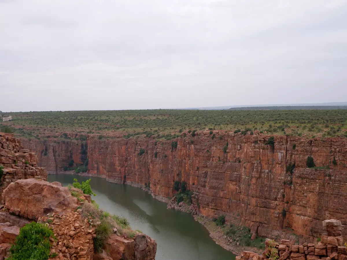
Gandikota is in Kadapa district, Andhra Pradesh. Its stunning canyon — nicknamed "Grand Canyon of India" — was carved by the Pennar River cutting through hills over millions of years.
Remember:
Gandikota = Kadapa = Andhra Pradesh = Pennar River.
Other rivers are in different regions:
- Cauvery: Karnataka/Tamil Nadu
- Manjira: Tributary of Godavari in Telangana
- Tungabhadra: Karnataka (near Hampi)
Gandikota canyon in Kadapa district, Andhra Pradesh is called the 'Grand Canyon of India' and was carved by the Pennar River over millions of years.
The question tests precise knowledge of which specific river created which landmark - students often confuse South Indian rivers and their associated geographical features.
Pennar River System
Geography Pennar
Pennar River: Course, Features & Key Locations
Pennar River flows through Karnataka and Andhra Pradesh, draining into Bay of Bengal
Creates the famous Gandikota Canyon in Kadapa district, Andhra Pradesh
Second largest east-flowing river of peninsular India after Godavari
Total length approximately 597 km
The Pennar River is a major east-flowing river of peninsular India that carved one of the country's most spectacular canyons at Gandikota, earning it the nickname 'Grand Canyon of India'.
Pennar River Profile
Aspect | Details |
|---|---|
Origin | Nandi Hills, Karnataka (Chikkaballapur district) |
States | Karnataka → Andhra Pradesh |
Major cities | Anantapur, Cuddapah (Kadapa), Nellore |
Length | Approximately 597 km |
Drainage area | About 55,213 sq km |
Outfall | Bay of Bengal at Nellore |
Key Features
Gandikota Canyon: Carved through Erramala hills in Kadapa district, creating spectacular gorge formations
Seasonal flow: Largely dependent on monsoons, often reduces to a trickle in summer
Major tributaries: Jayamangali, Kunderu, and Sagileru rivers
Economic importance: Irrigation through Somasila Dam and Kandaleru Dam
Gandikota Canyon
Source: The Times of India — What makes Andhra Pradesh's Gandikota Canyon so popular? | TimesTravel · timesofindia.indiatimes.com
Location trap: Gandikota is in Kadapa district, Andhra Pradesh — not Karnataka despite Pennar originating there
River confusion: Don't confuse with Penna (alternate spelling) or mix up with Tungabhadra which flows near Hampi
Tributary trap: Manjira is a Godavari tributary, not an independent major river
Other Peninsular Rivers
Geography Cauvery Manjira Tungabhadra
Major Peninsular Rivers: Cauvery, Manjira & Tungabhadra
Cauvery: Major south Indian river flowing through Karnataka and Tamil Nadu
Manjira: Important tributary of Godavari in Telangana region
Tungabhadra: Tributary of Krishna, famous for Hampi heritage site
Comparative Overview
River | Type | States | Famous For | Outfall/Joins |
|---|---|---|---|---|
Cauvery | Major east-flowing | Karnataka, Tamil Nadu | Jog Falls, Srirangapatna | Bay of Bengal |
Manjira | Godavari tributary | Maharashtra, Telangana | Nizam Sagar Dam | Godavari River |
Tungabhadra | Krishna tributary | Karnataka, Andhra Pradesh | Hampi ruins | Krishna River |
Pennar | Major east-flowing | Karnataka, Andhra Pradesh | Gandikota Canyon | Bay of Bengal |
Key Distinguishing Features
Cauvery: Originates in Western Ghats (Brahmagiri hills), creates Hogenakkal Falls
Manjira: Flows northward initially before joining Godavari — unusual direction for peninsular river
Tungabhadra: Formed by confluence of Tunga and Bhadra rivers in Karnataka
Geographic separation: Each river system serves distinct regions with minimal overlap
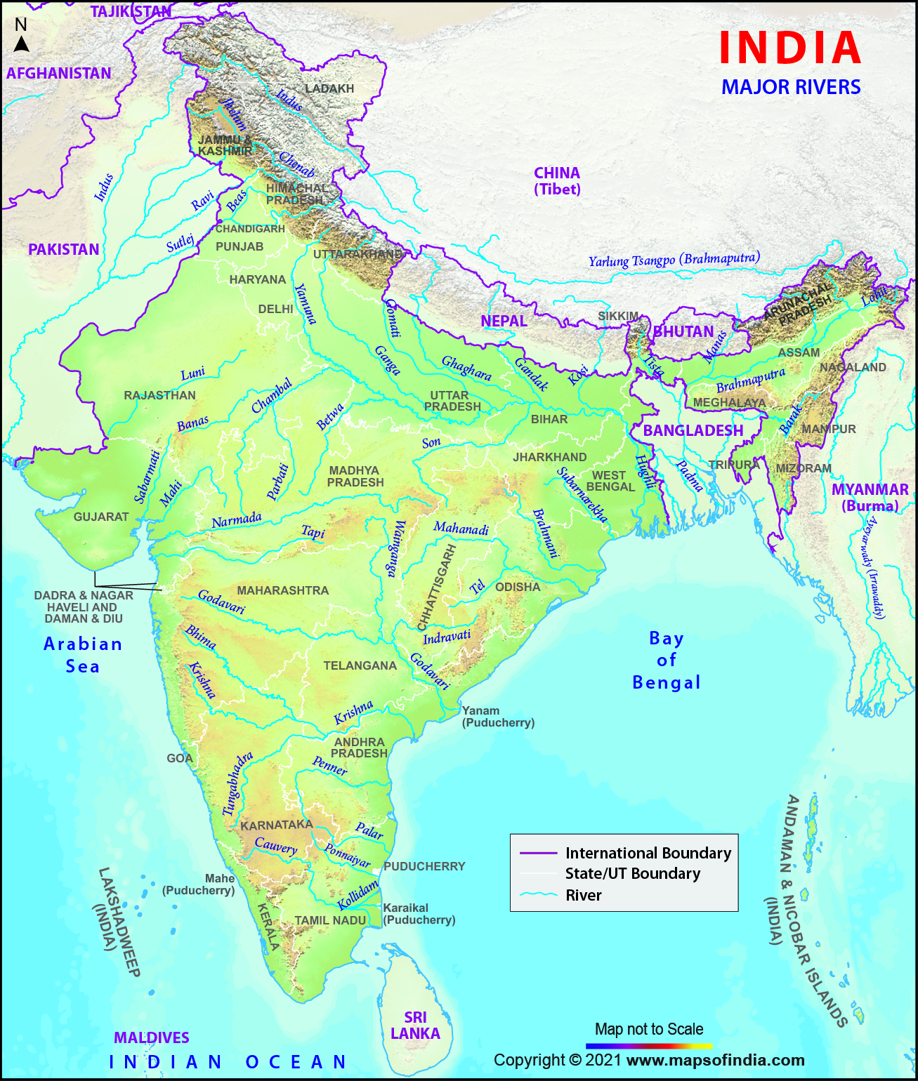
River Locations Map
Source: India Map — River Map of India | River System in India | Himalayan Rivers ... · www.mapsofindia.com
Tributary confusion: Manjira is a Godavari tributary, not an independent river reaching the sea
State mix-up: Tungabhadra flows through Karnataka (Hampi area), not Andhra Pradesh's interior
Direction trap: Cauvery flows east to Bay of Bengal, not west to Arabian Sea despite Western Ghats origin
Gandikota Canyon
Geography Gandikota canyon
Gandikota: India's Grand Canyon Formation & Significance
Gandikota Canyon in Kadapa district, Andhra Pradesh — nicknamed 'Grand Canyon of India'
Carved by Pennar River through Erramala hills over millions of years
Features red sandstone gorge formations and historical Gandikota Fort
Gandikota is a spectacular canyon formed by the Pennar River cutting through the Erramala hills in Andhra Pradesh. The dramatic gorge, with its red sandstone cliffs and winding river valley, has earned the nickname 'Grand Canyon of India'.
Canyon Formation Process
%%{init: {"flowchart": {"wrappingWidth": 460}}}%%
flowchart TD
  s1["`**Initial Flow**
**Pennar River** flows through relatively flat terrain`"]
  s2["`**Hill Encounter**
River meets **Erramala hills** — resistant rock formation`"]
  s3["`**Gradual Cutting**
Water erosion over **millions of years** cuts through sandstone`"]
  s4["`**Gorge Formation**
Deep **canyon** with vertical walls and river valley formed`"]
  s5["`**Modern Landscape**
**Gandikota Canyon** — dramatic red cliffs and winding river`"]
  s1 --> s2
  s2 --> s3
  s3 --> s4
  s4 --> s5
Tourist & Historical Significance
Gandikota Fort: 13th-century fortress built by Kakatiya dynasty on canyon rim
Geological importance: Excellent example of river erosion through sedimentary rocks
Tourism potential: Growing destination for adventure tourism and photography
Accessibility: Connected by road from Kadapa (about 15 km away)
State confusion: Gandikota is in Andhra Pradesh (Kadapa district), not Karnataka or Telangana
River attribution: Carved by Pennar River specifically — not Tungabhadra, Krishna, or Godavari
Nickname trap: Called 'Grand Canyon of India' — don't confuse with actual Grand Canyon in USA
East-Flowing Peninsular Rivers
Geography
East-Flowing Rivers of Peninsular India: Classification & Features
Major east-flowing rivers: Godavari, Krishna, Pennar, Cauvery — all drain into Bay of Bengal
Mature valleys: Form broad deltas and extensive agricultural plains
Longer courses compared to west-flowing rivers due to gentler eastern slope
East-flowing rivers of peninsular India drain the majority of the Deccan plateau towards the Bay of Bengal. These rivers flow down the gentler eastern slope, creating extensive valleys and fertile deltas.
Major East-Flowing Rivers
River | Length (km) | Origin | Delta/Outfall | Major Feature |
|---|---|---|---|---|
Godavari | ~1465 | Western Ghats (Maharashtra) | Godavari Delta | Largest peninsular river |
Krishna | ~1400 | Western Ghats (Maharashtra) | Krishna Delta | Second largest |
Cauvery | ~765 | Western Ghats (Karnataka) | Cauvery Delta | Sacred river of South |
Pennar | ~597 | Nandi Hills (Karnataka) | Near Nellore | Gandikota Canyon |
Mahanadi | ~858 | Chhattisgarh | Mahanadi Delta | Eastern India's major river |
Common Characteristics
Monsoon dependence: Flow varies dramatically between monsoon and dry seasons
Delta formation: Create extensive deltas due to heavy sediment load
Agricultural importance: Support major rice-growing regions in coastal plains
Gentle gradient: Longer courses with meandering patterns compared to west-flowing rivers
Size ranking: Godavari is largest, Krishna second, then Cauvery — don't mix up the order
Origin confusion: Most originate in Western Ghats but flow eastward — counterintuitive
Tributary classification: Manjira is a Godavari tributary, Tungabhadra is a Krishna tributary