Consider the following pairs:
Contents17
Consider the following pairs:
| Glacier | River | |
|---|---|---|
| 1. | Bandarpunch | Yamuna |
| 2. | Bara Shigri | Chenab |
| 3. | Milam | Mandakini |
| 4. | Siachen | Nubra |
| 5. | Zemu | Manas |
Which of the pairs given above are correctly matched?
- A1, 2 and 4
- B1, 3 and 4
- C2 and 5
- D3 and 5
Show answer
Answer: (A) 1, 2 and 4
The correct answer is (A) — 1, 2 and 4 are correctly matched.
Bandarpunch glacier feeds the Yamuna River (pair 1 — correct).
Bara Shigri glacier (the second longest glacier in the Himalayas) feeds the Chenab River (pair 2 — correct).
Milam glacier is in Uttarakhand's Pithoragarh district, but the Mandakini River originates from the Chorabari glacier near Kedarnath, not Milam (pair 3 — wrong).
Siachen glacier feeds the Nubra River in Ladakh (pair 4 — correct).
Zemu glacier (in Sikkim, near Kangchenjunga) is NOT connected to the Manas River, which flows through Bhutan (pair 5 — wrong).
Tip:
- Milam ≠ Mandakini
- Zemu ≠ Manas.
These are the wrong pairs to watch out for.
Glacier-river pairs test precise knowledge of Himalayan drainage origins, which matters because many major Indian rivers depend on glacial melt for their flow.
The question uses geographic name similarity as a trap - Milam glacier sounds like it could feed Mandakini river, but Mandakini actually originates from Chorabari glacier near Kedarnath.
Students must distinguish between glaciers in different Himalayan regions - Siachen in Ladakh feeds local Nubra river, while Zemu in Sikkim has no connection to distant Manas river in Bhutan.
Major Himalayan Glaciers
Geography Bandarpunch Bara Shigri Milam Siachen Zemu
Major Himalayan Glaciers: Location & Classification
Bara Shigri is the second longest glacier in the Himalayas
Siachen is the world's highest battlefield glacier in Ladakh
Milam glacier is located in Uttarakhand's Pithoragarh district
Zemu glacier is in Sikkim near Kangchenjunga peak
What Are Glaciers
Glaciers are massive bodies of ice formed from compressed snow over hundreds of years. The Himalayas contain some of Asia's most important glaciers that feed major river systems across India, Pakistan, and China.
Key Himalayan Glaciers
Glacier | Location | State/Region | Significance |
|---|---|---|---|
Bandarpunch | Garhwal Himalayas | Uttarakhand | Feeds Yamuna River |
Bara Shigri | Lahaul-Spiti | Himachal Pradesh | Second longest in Himalayas |
Milam | Pithoragarh district | Uttarakhand | Major glacier in Kumaon region |
Siachen | Eastern Karakoram | Ladakh | World's highest battlefield |
Zemu | Near Kangchenjunga | Sikkim | Largest glacier in Eastern Himalayas |
Himalayan Glacier Map
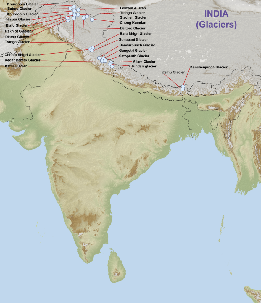
Source: LotusArise — Important Glaciers in India - UPSC - UPSC Notes » LotusArise IAS · lotusarise.com
Milam glacier does NOT feed Mandakini River — Mandakini comes from Chorabari glacier near Kedarnath
Zemu glacier in Sikkim is NOT connected to Manas River — Manas flows through Bhutan
Don't confuse Bara Shigri (Himachal Pradesh) with Baltoro glacier (Pakistan)
Siachen feeds Nubra River, not the Indus directly
Glacier-River Source Connections
Geography Yamuna Chenab Mandakini Nubra Manas
Glacier-River Source Connections: Correct Pairings
Bandarpunch glacier feeds Yamuna River in Garhwal region
Bara Shigri glacier feeds Chenab River in Himachal Pradesh
Siachen glacier feeds Nubra River in Ladakh region
How Glaciers Feed Rivers
Many major Indian rivers originate from glacial melt in the Himalayas. The glacier acts as a natural reservoir, releasing water through melting that becomes the river's headwater source.
Correct Glacier-River Pairs
Glacier | River Fed | River System | Final Destination |
|---|---|---|---|
Bandarpunch | Yamuna | Ganga system | Bay of Bengal |
Bara Shigri | Chenab | Indus system | Arabian Sea |
Siachen | Nubra | Indus system | Arabian Sea |
Wrong Pairs from Question
Wrong Pairing | Reality | Correct Source |
|---|---|---|
Milam → Mandakini | Milam is in Pithoragarh, Mandakini flows near Kedarnath | Mandakini comes from Chorabari glacier |
Zemu → Manas | Zemu is in Sikkim, Manas flows through Bhutan | Manas originates in Bhutan Himalayas |
Geographic mismatch trap: Zemu (Sikkim) cannot feed Manas (Bhutan) — they're in different countries
Kedarnath confusion: Mandakini flows near Kedarnath temple, not from distant Milam glacier
UPSC often pairs real glaciers with wrong rivers to test precise geographical knowledge
Indian River Origins & Sources
Geography Yamuna Chenab Mandakini Manas
Indian River Origins: Himalayan vs Peninsular Sources
Yamuna originates from Yamunotri glacier (Bandarpunch group) in Uttarakhand
Chenab is formed by confluence of Chandra and Bhaga rivers in Himachal Pradesh
Mandakini originates from Chorabari glacier near Kedarnath temple
Manas originates in Bhutan Himalayas, enters India through Assam
River Classification
Indian rivers are classified into Himalayan rivers (snow-fed, perennial) and Peninsular rivers (rain-fed, seasonal). Most major north Indian rivers originate from glacial sources in the Himalayas.
River Origins by System
River | Origin Source | River System | Flow Pattern |
|---|---|---|---|
Yamuna | Yamunotri glacier (Bandarpunch) | Ganga tributary | Perennial |
Chenab | Chandra + Bhaga confluence | Indus tributary | Perennial |
Mandakini | Chorabari glacier | Ganga tributary | Perennial |
Manas | Bhutan Himalayas | Brahmaputra tributary | Perennial |
Indian River Systems
# Indian Rivers
## Ganga System
- Yamuna
- Mandakini
- Alaknanda
- Bhagirathi
## Indus System
- Chenab
- Ravi
- Beas
- Sutlej
- Jhelum
## Brahmaputra System
- Manas
- Subansiri
- Kameng
- Lohit
Indian River Origins Map
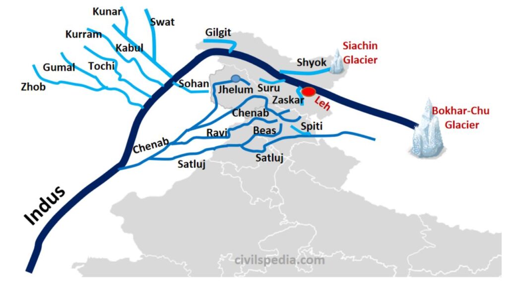
Source: RAJ RAS — Major Rivers - Connect Civils · rajras.in
Indian Drainage Systems
Geography
Indian Drainage Systems: Classification & Patterns
India has 4 major drainage systems: Ganga, Indus, Brahmaputra, and Peninsular rivers
Himalayan rivers are perennial and snow-fed with glacial origins
Peninsular rivers are seasonal and rain-fed flowing east or west
Drainage System Basics
A drainage system includes a river and all its tributaries that drain a specific area. India's drainage is divided by the main watershed running along the Western Ghats and Aravallis.
Major Indian Drainage Systems
System | Origin | Direction | Outflow | Key Features |
|---|---|---|---|---|
Ganga | Gangotri glacier | East | Bay of Bengal | Largest basin, most fertile plains |
Indus | Mansarovar region | Southwest | Arabian Sea | Mostly in Pakistan, 5 tributaries |
Brahmaputra | Mansarovar region | East | Bay of Bengal | Flows through Tibet, Bangladesh |
Peninsular East | Western Ghats | East | Bay of Bengal | Godavari, Krishna, Cauvery |
Peninsular West | Western Ghats | West | Arabian Sea | Narmada, Tapti, short rivers |
Drainage Classification
# Indian Drainage
## By Origin
- Himalayan (Glacial)
- Peninsular (Plateau)
- Coastal (Local)
## By Flow Pattern
- Perennial (Year-round)
- Seasonal (Monsoon)
- Ephemeral (Temporary)
## By Direction
- Eastward (Bay of Bengal)
- Westward (Arabian Sea)
- Inland (No sea outlet)