If you travel by road from Kohima to Kottayam, what is the minimum number of States within India through which you can travel, including the origin and the destination?
Contents17
- A6
- B7
- C8
- D9
Show answer
Answer: (B) 7
To solve this, you need to trace the shortest road route from Kohima (capital of Nagaland, in northeast India) to Kottayam (in Kerala, in southwest India) on the map and count how many states you must pass through.
The optimal route passes through 7 states:
- (1) Nagaland (origin — Kohima),
- (2) Assam (Nagaland connects to the rest of India via Assam),
- (3) West Bengal (via the Siliguri corridor or through lower Assam into West Bengal),
- (4) Odisha (continuing south from West Bengal along the east coast),
- (5) Andhra Pradesh (south of Odisha),
- (6) Tamil Nadu (continuing south/southwest from Andhra Pradesh),
- (7) Kerala (destination — Kottayam).
Some students might wonder about alternative routes through Jharkhand, Chhattisgarh, or Karnataka, but these would add more states, not fewer.
The route through the eastern coast (West Bengal → Odisha → Andhra Pradesh) and then cutting across to Tamil Nadu and Kerala is the most direct.
This question requires excellent map skills and knowledge of India's political geography — specifically how states are arranged and which borders which.
(Source: Atlas of India)
This route crosses India diagonally from the northeastern corner to the southwestern corner, requiring knowledge of how states connect across the eastern corridor.
The key insight is that Nagaland can only connect to mainland India through Assam, and the eastern coastal route through West Bengal-Odisha-Andhra Pradesh is shorter than going through central India.
UPSC is testing whether students can visualize the political map of India and trace optimal routes between distant points, not just memorize state locations.
Northeast India Political Geography
Geography Kohima Nagaland
Northeast India: States, Capitals & Strategic Geography
Kohima is the capital of Nagaland in Northeast India
Northeast connects to mainland India only through Siliguri Corridor in West Bengal
Seven Sister States: Arunachal Pradesh, Assam, Manipur, Meghalaya, Mizoram, Nagaland, Tripura
All Northeast states except Assam are landlocked and border international boundaries
Strategic Location
Northeast India is connected to mainland India through the narrow Siliguri Corridor in West Bengal, also called Chicken's Neck. This 20-22 km wide corridor is the only land route linking the Seven Sister States to the rest of India.
Northeast States & Capitals
State | Capital | Borders | Key Feature |
|---|---|---|---|
Arunachal Pradesh | Itanagar | China, Myanmar | Largest NE state |
Assam | Dispur | Bhutan | Only plains state, oil refineries |
Manipur | Imphal | Myanmar | Loktak Lake |
Meghalaya | Shillong | Bangladesh | Wettest place (Mawsynram) |
Mizoram | Aizawl | Myanmar, Bangladesh | Highest literacy in NE |
Nagaland | Kohima | Myanmar | Hornbill Festival |
Tripura | Agartala | Bangladesh | Surrounded by Bangladesh on 3 sides |
Northeast India Map
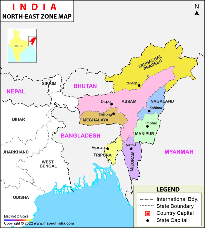
Source: India Map — North-East India Map, Seven Sisters of India · www.mapsofindia.com
Trap: Confusing Kohima (Nagaland) with Imphal (Manipur) — both are hill state capitals
Trap: Thinking Northeast has direct road access to mainland — all routes go through Assam first
Trap: Missing that Sikkim is NOT one of the Seven Sisters despite being in the region
Southern Peninsula - Kerala Geography
Geography Kottayam Kerala
Kerala: Districts, Cities & Geographic Features
Kottayam is a major district and city in central Kerala
Kerala has 14 districts arranged north-south along the Malabar Coast
Kerala borders Tamil Nadu (east/south) and Karnataka (north/northeast)
Western Ghats run parallel to Kerala's coast, creating three geographic zones
Geographic Position
Kerala stretches along India's southwest coast for about 580 km. Kottayam lies in central Kerala, known for rubber plantations, backwaters, and being a major commercial hub between the coastal plains and Western Ghats.
Kerala's Key Districts
Region | Major Districts | Key Cities | Geographic Feature |
|---|---|---|---|
North Kerala | Kasaragod, Kannur, Kozhikode | Kozhikode (Calicut) | Spice coast, major ports |
Central Kerala | Thrissur, Kottayam, Ernakulam | Kottayam, Kochi | Backwaters, rubber plantations |
South Kerala | Alappuzha, Kollam, Thiruvananthapuram | Thiruvananthapuram (capital) | Coconut groves, beaches |
Kerala's Bordering States
# Kerala Borders
## Tamil Nadu
- Eastern border
- Coimbatore connects
- Madurai region
- Access to Chennai
## Karnataka
- Northern border
- Bangalore connects
- Mysore region
- Shortest route to Mumbai
## Arabian Sea
- Western coast
- Natural boundary
- Ports and fishingTrap: Confusing Kottayam with Kottakkal (famous for Arya Vaidya Sala) — different places in Kerala
Trap: Assuming direct Kerala-Andhra Pradesh border — Tamil Nadu lies between them
Trap: Missing that routes from Northeast to Kerala must pass through Tamil Nadu as the final approach
Interstate Boundaries & Connectivity
Geography
India's Interstate Road Connectivity & Border Patterns
India has 28 states and 8 Union Territories with complex interstate boundaries
Eastern Corridor (WB→Odisha→AP→TN) is the shortest north-south route along the coast
Siliguri Corridor is the only land connection between Northeast and mainland India
Route Planning Logic
Interstate travel in India follows geographic corridors. The eastern corridor along the Bay of Bengal provides the shortest route between northern and southern extremes, while the western corridor along the Arabian Sea offers an alternative but longer path.
Major Interstate Corridors
Corridor | States Covered | Total Distance | Key Features |
|---|---|---|---|
Eastern Corridor | WB → Odisha → Andhra Pradesh → Tamil Nadu | ~1,500 km | Shortest north-south route, coastal |
Western Corridor | Gujarat → Maharashtra → Goa → Karnataka | ~1,200 km | Industrial belt, ports |
Northern Corridor | Punjab → Haryana → UP → Bihar → WB | ~1,800 km | Gangetic plains, GT Road |
Central Corridor | MP → Maharashtra → Karnataka → Kerala | ~1,400 km | Deccan route, hilly terrain |
Kohima to Kottayam Route
%%{init: {"flowchart": {"wrappingWidth": 460}}}%%
flowchart TD
  s1["`****Nagaland** (Kohima)**
Starting point in Northeast India`"]
  s2["`****Assam****
Mandatory transit - only connection to mainland`"]
  s3["`****West Bengal****
Via Siliguri Corridor to enter peninsular India`"]
  s4["`****Odisha****
Continuing south along eastern coast`"]
  s5["`****Andhra Pradesh****
Further south on coastal corridor`"]
  s6["`****Tamil Nadu****
Entering southern peninsula`"]
  s7["`****Kerala** (Kottayam)**
Final destination in southwest India`"]
  s1 --> s2
  s2 --> s3
  s3 --> s4
  s4 --> s5
  s5 --> s6
  s6 --> s7
India Political Map
Political map of India showing all state boundaries with the eastern corridor route from Northeast to Kerala highlighted
The eastern corridor provides the shortest interstate route from Northeast to South India
Trap: Forgetting Assam as mandatory transit from Northeast — direct routes don't exist
Trap: Trying western routes via Jharkhand/Chhattisgarh — these add states, not reduce them
Trap: Missing Andhra Pradesh in the eastern corridor — it lies between Odisha and Tamil Nadu
Trap: Confusing current Andhra Pradesh boundaries after Telangana formation in 2014
Map Reading & Route Optimization
Geography
UPSC Map-Based Problem Solving Techniques
Always identify start and end coordinates on the map first
Count mandatory transit states that cannot be bypassed
Eliminate longer alternative routes systematically
Consider geographic barriers like mountains, deserts, international borders
Systematic Approach
UPSC route questions test your ability to visualize India's political map and trace optimal paths. Success requires knowing which states are landlocked, which have coastal access, and which serve as mandatory transit points.
Route Optimization Principles
Coastal advantage: Eastern and western corridors are usually shorter than inland routes due to fewer state boundaries
Transit chokepoints: Northeast-to-mainland routes must pass through Assam; Kashmir routes must pass through Punjab/Haryana
Geographic logic: Follow river valleys (Ganga), coast lines, or mountain passes rather than cutting across difficult terrain
Political boundaries: Newer states (Jharkhand, Chhattisgarh, Telangana) often create additional boundaries in previously direct routes
Infrastructure reality: Major national highways follow the most practical geographic routes, which usually match the shortest state count
Route Analysis Method
%%{init: {"flowchart": {"wrappingWidth": 460}}}%%
flowchart TD
  s1["`****Locate endpoints****
Mark origin and destination cities on mental map`"]
  s2["`****Identify geographic constraints****
Note mountains, international borders, water bodies`"]
  s3["`****List possible corridors****
Eastern coast, western coast, central plateau, northern plains`"]
  s4["`****Trace each route****
Count states for each viable corridor option`"]
  s5["`****Select minimum count****
Choose the route with fewest state boundaries`"]
  s1 --> s2
  s2 --> s3
  s3 --> s4
s4 --> s5Trap: Forgetting to count origin and destination states — question asks for total including both ends
Trap: Using outdated maps — Telangana (2014), Ladakh (2019) changed many route calculations
Trap: Assuming shortest distance equals fewest states — geographic barriers can force longer routes
Trap: Missing Union Territories in the count — Delhi, Chandigarh, Puducherry are separate entities