Which of the following has/have shrunk immensely/dried up the recent past due to human activities? 1. Aral Sea 2. Black Sea 3. Lake Baikal Select the correct answer using the code given below:
Contents18
- A1 only
- B2 and 3
- C2 only
- D1 and 3
Show answer
Answer: (A) 1 only
Correct Answer: (a) 1 only
Aral Sea — CORRECT: The Aral Sea (located between Kazakhstan and Uzbekistan) has dramatically shrunk by about 75% in the last 50 years. The main cause was diversion of its feeder rivers (Amu Darya and Syr Darya) for cotton irrigation by the Soviet Union. It went from 68 meters depth in the 1960s to less than 10 meters. This is one of the worst environmental disasters caused by humans.
Black Sea — WRONG: The Black Sea has NOT dried up. It is a large, stable sea bordered by Turkey, Russia, Ukraine, and other countries. It has its own environmental issues (pollution, dead zones) but has not shrunk immensely.
Lake Baikal — WRONG: Lake Baikal in Russia is the world's deepest and oldest freshwater lake. While water levels have fluctuated and gone below critical marks a few times, it has NOT 'shrunk immensely' like the Aral Sea. The fluctuations are relatively minor.
REMEMBER:
- Aral Sea = the big shrinkage story (75% gone due to irrigation).
- Black Sea = stable, not shrinking.
- Lake Baikal = fluctuating but not dramatically shrunk.
The Aral Sea has shrunk by about 75% since the 1960s due to Soviet irrigation projects diverting its feeder rivers for cotton farming, making it one of the world's worst human-caused environmental disasters.
UPSC tests this to check if students can distinguish between genuine environmental catastrophes like the Aral Sea versus stable water bodies like the Black Sea and Lake Baikal that face different issues but haven't dramatically shrunk.
Aral Sea Environmental Disaster
Geography Aral Sea
Aral Sea: World's Worst Human-Made Environmental Disaster
Aral Sea has shrunk by 75% in 50 years due to river diversion for cotton irrigation
Located between Kazakhstan and Uzbekistan, fed by Amu Darya and Syr Darya rivers
Depth reduced from 68 meters in 1960s to less than 10 meters today
Soviet-era cotton irrigation projects were the primary cause
What Happened
The Aral Sea was once the world's fourth-largest lake. Starting in the 1960s, the Soviet Union diverted its two main feeder rivers - Amu Darya and Syr Darya - for massive cotton irrigation projects in the desert. This cut off the sea's water supply, causing it to shrink dramatically over five decades.
Scale of Shrinkage
Parameter | 1960s | Present Day | Change |
|---|---|---|---|
Surface Area | 68,000 sq km | 17,000 sq km | 75% reduction |
Maximum Depth | 68 meters | Less than 10 meters | 85% reduction |
Water Volume | 1,093 cubic km | 75 cubic km | 93% reduction |
Salinity | 10 g/L | 100+ g/L | 10x increase |
Environmental Consequences
Fishing industry collapse: 40,000 jobs lost, commercial fishing ended by 1980s
Toxic dust storms: Exposed lakebed contains pesticides and fertilizers from cotton farming
Climate change: Local temperatures became more extreme, less rainfall in region
Health crisis: Respiratory diseases, cancer rates increased in nearby populations
Ship graveyards: Fishing boats now sit in desert, hundreds of kilometers from water
Visual Evidence
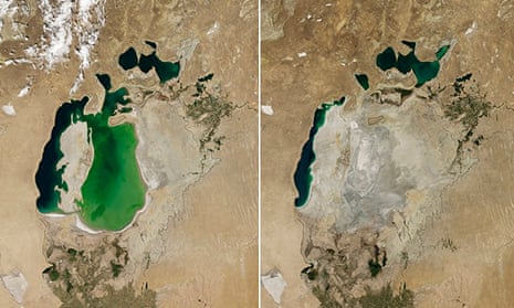
Source: The Guardian — Satellite images show Aral Sea basin 'completely dried ... · www.theguardian.com
Trap: Don't confuse Aral Sea (shrunk massively) with Black Sea (stable size)
Trap: Lake Baikal has water level fluctuations but has NOT 'shrunk immensely' like Aral Sea
Trap: The cause was irrigation diversion, not climate change or natural drought
Black Sea Characteristics
Geography Black Sea
Black Sea: Stable Inland Sea of Europe-Asia
Black Sea is a stable inland sea that has NOT shrunk or dried up
Bordered by Turkey, Russia, Ukraine, Romania, Bulgaria, Georgia
Connected to Mediterranean Sea via Bosphorus and Dardanelles straits
Geographic Position
The Black Sea is a large inland sea located between Europe and Asia Minor. It connects to the Mediterranean Sea through the narrow Turkish straits, maintaining stable water levels through this connection and river inflows.
Bordering Countries
Country | Coastline Position | Major Ports |
|---|---|---|
Turkey | Southern coast | Istanbul, Trabzon |
Russia | Northern & Eastern coast | Sochi, Novorossiysk |
Ukraine | Northern coast | Odessa, Sevastopol |
Romania | Western coast | Constanta |
Bulgaria | Western coast | Varna, Burgas |
Georgia | Eastern coast | Batumi, Poti |
Key Features
Area: 436,000 sq km - much larger and more stable than Aral Sea
Maximum depth: 2,212 meters in central basin
Anoxic waters: Deep waters lack oxygen, preserving ancient shipwrecks
Strategic importance: Controls access between Europe and Asia via Turkish straits
Trap: Black Sea is stable and has NOT shrunk - don't confuse with Aral Sea
Trap: Black Sea has environmental issues (pollution, dead zones) but NOT massive shrinkage
Lake Baikal Features
Geography Lake Baikal
Lake Baikal: World's Deepest Freshwater Lake
Lake Baikal is the world's deepest and oldest freshwater lake
Located in Siberia, Russia - has NOT shrunk immensely like Aral Sea
Water levels fluctuate but no massive shrinkage has occurred
Contains 20% of world's unfrozen fresh water
World Records
Lake Baikal in Siberia, Russia holds multiple world records as the deepest, oldest, and largest freshwater lake by volume. While it experiences natural water level fluctuations, it has not undergone the dramatic shrinkage seen in the Aral Sea.
Lake Baikal Statistics
Parameter | Value | World Ranking |
|---|---|---|
Maximum Depth | 1,642 meters | World's deepest lake |
Age | 25-30 million years | World's oldest lake |
Volume | 23,615 cubic km | 20% of world's fresh water |
Surface Area | 31,722 sq km | 7th largest by area |
Length | 636 km | Crescent-shaped |
Width | 79 km (average) | Varies along length |
Environmental Status
Water level fluctuations: Natural variations occur but no massive shrinkage
UNESCO World Heritage Site: Recognized for unique biodiversity since 1996
Endemic species: Over 1,700 species found nowhere else, including Baikal seal
Pollution concerns: Industrial waste and tourism impact but lake remains stable
Lake Location
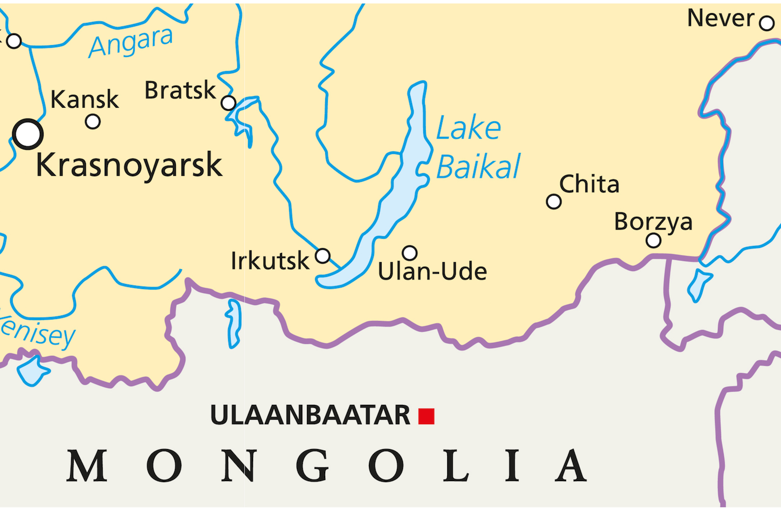
Source: Live Science — Lake Baikal: World's Largest, Deepest Lake | Live Science · www.livescience.com
Trap: Lake Baikal fluctuates but has NOT 'shrunk immensely' - don't equate minor fluctuations with Aral Sea's 75% shrinkage
Trap: Baikal is freshwater (not saltwater like Aral Sea became)
Trap: Located in Russia/Siberia, not Central Asia like Aral Sea
Human Impact on Water Bodies
Geography human activities shrunk immensely dried up
Human Activities Causing Water Body Shrinkage
Water diversion for irrigation is the primary cause of lake/sea shrinkage
Aral Sea is the most dramatic example - 75% shrinkage in 50 years
Not all water level changes are human-caused - distinguish natural fluctuations from massive shrinkage
Types of Human Impact
Human activities can dramatically alter water bodies through direct water diversion, dam construction, and excessive groundwater extraction. The scale of impact varies from minor fluctuations to complete desiccation.
Major Cases Worldwide
Water Body | Location | Human Cause | Impact Scale | Current Status |
|---|---|---|---|---|
Aral Sea | Kazakhstan-Uzbekistan | River diversion for cotton irrigation | 75% shrinkage | Nearly dried up |
Lake Chad | Chad-Nigeria-Niger | Irrigation + climate change | 90% shrinkage | Severely reduced |
Dead Sea | Israel-Jordan | Water diversion from Jordan River | 30% shrinkage | Continuing to shrink |
Lake Urmia | Iran | Dam construction + drought | 70% shrinkage | Critical state |
Salton Sea | California, USA | Agricultural runoff + evaporation | Significant shrinkage | Ongoing crisis |
How Water Diversion Causes Shrinkage
%%{init: {"flowchart": {"wrappingWidth": 460}}}%%
flowchart TD
  s1["`**Water Source Diversion**
Rivers feeding the lake/sea are diverted for irrigation or industrial use`"]
  s2["`**Reduced Inflow**
Water input to the lake drops dramatically while evaporation continues`"]
  s3["`**Water Level Drops**
Lake begins shrinking as outflow (evaporation) exceeds inflow`"]
  s4["`**Salinity Increases**
Remaining water becomes more concentrated with salts and minerals`"]
  s5["`**Ecosystem Collapse**
Fish die, birds migrate away, local economy and environment destroyed`"]
  s1 --> s2
  s2 --> s3
  s3 --> s4
s4 --> s5Trap: Distinguish massive shrinkage (like Aral Sea's 75%) from minor fluctuations (like Lake Baikal)
Trap: Human-caused shrinkage vs natural water level changes - question asks specifically about human activities
Trap: Recent past timeframe - focus on dramatic changes in last 50-100 years, not geological timescales