With reference to the Digital India Land Records Modernisation Programme, consider the following statements: 1. To implement the scheme, the Central Government provides 100% funding. 2. Under the Scheme, Cadastral Maps are digitized. 3. An initiative has been undertaken to transliterate the Records of Rights from local language to any of the languages recognized by the Constitution of India. Which of the statements given above are correct?
Contents13
- A1 and 2 only
- B2 and 3 only
- C1 and 3 only
- D1, 2 and 3
Show answer
Answer: (D) 1, 2 and 3
Correct Answer: (d) All three statements are correct.
Statement 1: 100% Central Government funding — ✓ CORRECT.
DILRMP was converted to a Central Sector Scheme in 2016 with full Central funding.
Statement 2: Cadastral maps are digitized — ✓ CORRECT.
Digitization of cadastral maps (land parcel maps) is one of the basic components.
Statement 3: Records of Rights are being transliterated into all 22 Schedule VIII languages — ✓ CORRECT.
With help from C-DAC Pune, land records in local languages are being transliterated to break language barriers.
Other features to know:
ULPIN (Bhu-Aadhaar) — a 14-digit unique ID for each land parcel based on geo-coordinates.
DILRMP became a Central Sector Scheme with 100% Central funding in 2016, making land record digitization a national priority affecting millions of farmers.
The scheme creates ULPIN (Bhu-Aadhaar) - a 14-digit unique ID for each land parcel based on geo-coordinates, similar to how Aadhaar works for individuals.
UPSC is testing knowledge of both the funding structure change and technical components like cadastral mapping and multi-language transliteration.
Digital India Land Records Modernisation Programme
Indian Economy Digital India Land Records Modernisation Programme DILRMP Cadastral Maps Records of Rights
DILRMP: Components, Funding & Implementation
DILRMP is a Central Sector Scheme with 100% Central funding since 2016
Digitizes cadastral maps and transliterates Records of Rights into all 22 constitutional languages
Creates ULPIN (Bhu-Aadhaar) - a 14-digit unique ID for each land parcel
Implemented with technical support from C-DAC Pune for language transliteration
DILRMP aims to modernize India's land records system by digitizing cadastral maps, creating unique land IDs, and breaking language barriers in rural areas.
Key Components & Features
Component | What it Does | Key Details |
|---|---|---|
Cadastral Maps Digitization | Converts paper land parcel maps to digital format | Shows boundaries, ownership, land use |
Records of Rights (RoR) | Transliterates local language records | Available in all 22 Schedule VIII languages |
ULPIN (Bhu-Aadhaar) | Creates unique land identification | 14-digit ID based on geo-coordinates |
Integration with Revenue Courts | Links land records with legal system | Faster dispute resolution |
Funding & Administrative Structure
Originally a Centrally Sponsored Scheme - converted to Central Sector Scheme in 2016
100% Central Government funding - no state contribution required
Technical implementation support from C-DAC Pune for language processing
Covers mutation, settlement, survey and dispute resolution components
Question Context
This PYQ tests knowledge of DILRMP's funding pattern (Central vs Centrally Sponsored), technical components (cadastral maps), and language accessibility features. All three statements are correct.
Trap: Confusing Central Sector (100% Central funding) with Centrally Sponsored (shared funding)
Trap: Thinking cadastral maps are only about ownership - they also show boundaries and land use
Trap: Assuming transliteration covers only major languages - it includes all 22 constitutional languages
Remember: ULPIN = Bhu-Aadhaar - both terms refer to the same 14-digit land ID
Central Sector vs Centrally Sponsored Schemes
Indian Economy Central Government 100% funding
Scheme Classification: Funding & Implementation Patterns
Central Sector Schemes: 100% Central funding, implemented by Central agencies
Centrally Sponsored Schemes: Shared funding between Centre and States, implemented by States
State Schemes: 100% State funding, designed and implemented by States
Government schemes are classified based on funding source and implementing agency. This classification determines Centre-State financial responsibilities and administrative control.
Scheme Classification Matrix
Scheme Type | Funding Pattern | Implementing Agency | Examples |
|---|---|---|---|
Central Sector | 100% Central | Central Ministries/Agencies | DILRMP, PM-KISAN, Digital India |
Centrally Sponsored | 60:40 or 90:10 (Centre:State) | State Governments | MGNREGA, Pradhan Mantri Gram Sadak Yojana |
Core Centrally Sponsored | 100% Central (special category) | State Governments | Mid-Day Meal Scheme |
State Schemes | 100% State | State Governments | State-specific welfare schemes |
Key Distinctions for UPSC
Central Sector: Centre controls both money and implementation
Centrally Sponsored: Centre provides money, States implement
Funding ratios vary: 60:40 for general states, 90:10 for NE states in CSS
14th Finance Commission reduced Centre's role - many schemes converted from CSS to Central Sector
Trap: All 100% Central funding schemes are not Central Sector - some CSS have 100% funding too
Trap: Assuming PM schemes are always Central Sector - PM Gram Sadak Yojana is Centrally Sponsored
Remember: DILRMP converted from CSS to Central Sector in 2016 - shows the trend post-14th FC
Cadastral Mapping & Land Records System
Indian Economy Cadastral Maps
Cadastral Maps: Land Parcel Documentation System
Cadastral maps show individual land parcels with boundaries, ownership, and land use details
Essential for property rights, taxation, and dispute resolution in rural areas
Digitization enables GIS-based mapping and integration with revenue systems
Cadastral mapping is the foundation of land administration - it creates detailed maps showing individual land parcels with precise boundaries, ownership details, and land classification.
Components of Cadastral System
Component | What it Contains | Purpose |
|---|---|---|
Survey Numbers | Unique ID for each land parcel | Easy identification and tracking |
Boundaries | Precise parcel limits with measurements | Prevent disputes, enable transactions |
Ownership Details | Current owner, co-owners, tenancy rights | Establish clear property rights |
Land Classification | Agricultural, residential, commercial use | Taxation and planning purposes |
Area Measurements | Exact size in acres/hectares | Revenue assessment and valuation |
Digitization Benefits
Eliminates tampering - digital records cannot be easily altered like paper documents
Faster transactions - property registration becomes quicker with verified digital records
Dispute reduction - clear boundaries and ownership reduce litigation
Integration potential - links with banks for Kisan Credit Cards and loan processing
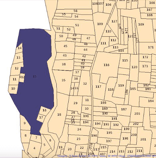
Source: Landeed — Maharashtra Survey Boundary Map – Download Official Digital Maps · web.landeed.com
Trap: Cadastral maps are not just about ownership - they include boundaries, classification, and area
Remember: Survey numbers are the basic unit of cadastral mapping in India
Don't confuse with revenue maps - cadastral maps are more detailed and parcel-specific
Language Transliteration in Digital Governance
Indian Economy transliterate Records of Rights local language Constitution of India
Breaking Language Barriers: Transliteration in Land Records
Records of Rights being transliterated from local languages to all 22 Schedule VIII languages
C-DAC Pune provides technical support for language processing and transliteration
Enables cross-state mobility and understanding of land documents
Transliteration converts land records from local scripts to constitutional languages, making them accessible to migrant farmers, banks, and officials across states.
Schedule VIII Languages Coverage
Language Group | Major Languages | Script Family | States Primarily Covered |
|---|---|---|---|
Indo-Aryan | Hindi, Bengali, Gujarati, Punjabi | Devanagari, Bengali, Gurmukhi | Northern & Western India |
Dravidian | Tamil, Telugu, Kannada, Malayalam | Tamil, Telugu, Kannada scripts | Southern India |
Others | Assamese, Odia, Urdu, Kashmiri | Various scripts | Eastern & J&K regions |
Tribal Languages | Santali, Bodo | Ol Chiki, Devanagari | Tribal areas across states |
Implementation & Benefits
C-DAC Pune developed multilingual software solutions for accurate transliteration
Helps migrant farmers understand land documents when moving across states
Enables banks and financial institutions to process land documents in familiar languages
Court proceedings become easier with standardized transliterated records
Remember: All 22 Schedule VIII languages are covered - not just major regional languages
C-DAC Pune handles technical implementation - important for Science & Tech questions too
Don't confuse transliteration (script conversion) with translation (meaning conversion)