With reference to the United Nations Convention on the Law of Sea, consider the following statements: 1. A coastal state has the right to establish the breadth of its territorial sea up to a limit not exceeding 12 nautical miles, measured from baseline determined in accordance with the convention. 2. Ships of all states, whether coastal or land-locked, enjoy the right of innocent passage through the territorial sea. 3. The Exclusive Economic Zone shall not extend beyond 200 nautical miles from the baseline from which the breadth of the territorial sea is measured. Which of the statements given above are correct?
Contents14
- A1 and 2 only
- B2 and 3 only
- C1 and 3 only
- D1, 2 and 3
Show answer
Answer: (D) 1, 2 and 3
The answer is (D) All three are correct.
These are key provisions of UNCLOS (United Nations Convention on the Law of the Sea):
Statement 1 is CORRECT:
Every coastal state can claim a territorial sea up to 12 nautical miles from its baseline. Within this zone, the state has full sovereignty (like its land territory).
Statement 2 is CORRECT:
ALL ships — whether from coastal or landlocked countries — have the right of "innocent passage" through any country's territorial sea. "Innocent passage" means passing through peacefully without threatening the coastal state's security. Even a landlocked country like Nepal can send its ships through India's territorial waters.
Statement 3 is CORRECT:
The Exclusive Economic Zone (EEZ) extends up to 200 nautical miles from the baseline. In this zone, the coastal state has rights over natural resources (fishing, oil, minerals) but other countries can navigate freely.
Quick summary of maritime zones:
- Territorial Sea: 0-12 nautical miles (full sovereignty)
- EEZ: up to 200 nautical miles (resource rights only)
- Continental Shelf: Can extend beyond 200 nm in some cases
UNCLOS defines the maritime zones where countries can claim sovereignty and resource rights, affecting global trade routes worth trillions of dollars annually.
Maritime boundary disputes in the South China Sea and Indo-Pacific region have made UNCLOS provisions highly relevant for India's foreign policy and economic interests.
The question tests precise knowledge of the three main maritime zones - territorial sea, EEZ, and the rights that apply in each zone.
UNCLOS Maritime Zones
World Affairs (International Relations) territorial sea Exclusive Economic Zone 12 nautical miles 200 nautical miles
UNCLOS Maritime Zones: Territorial Sea & EEZ Limits
Territorial Sea: up to 12 nautical miles from baseline with full coastal state sovereignty
EEZ extends up to 200 nautical miles from baseline with resource rights only
Innocent passage right applies to all ships (coastal and landlocked states) through territorial sea
Baseline is the reference line from which all maritime zones are measured
UNCLOS (United Nations Convention on the Law of the Sea) is the global treaty that defines maritime boundaries and rights. It creates distinct zones with different levels of coastal state control, measured from a baseline typically following the low-water line of the coast.
Maritime Zone Comparison
Zone | Distance from Baseline | Coastal State Rights | Other States' Rights |
|---|---|---|---|
Territorial Sea | Up to 12 nautical miles | Full sovereignty (like land territory) | Innocent passage only |
Contiguous Zone | Up to 24 nautical miles | Limited enforcement (customs, immigration, sanitary) | Free navigation |
Exclusive Economic Zone | Up to 200 nautical miles | Resource rights (fishing, minerals, energy) | Free navigation and overflight |
Continental Shelf | Up to 200 nm (can extend further) | Seabed resources only | Water column navigation free |
Innocent Passage Rights
All states (coastal and landlocked) enjoy innocent passage through territorial seas
Innocent passage means continuous, expeditious transit without threatening coastal state security
Prohibited activities during passage: weapons practice, fishing, research, aircraft operations
Coastal state cannot charge fees or require prior authorization for innocent passage
Submarines must surface and show their flag during innocent passage
Maritime Zones Visualization
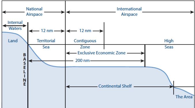
Source: Drishti IAS — UNCLOS Maritime Zones - Drishti IAS · www.drishtiias.com
Trap: Confusing territorial sea (12 nm) with contiguous zone (24 nm) limits
Trap: Thinking landlocked states have no innocent passage rights — they do have them
Trap: Assuming EEZ gives full sovereignty — it only gives resource rights
Trap: Missing that baseline measurement applies to all zones, not just territorial sea
UNCLOS Convention Framework
World Affairs (International Relations) United Nations Convention on the Law of Sea
UNCLOS: The Constitution of the Oceans
UNCLOS entered force in 1994 and governs all ocean activities globally
168 parties including India; USA has not ratified but follows customary provisions
Called Constitution of the Oceans — most comprehensive maritime law treaty
UNCLOS is the comprehensive international agreement that governs all uses of the world's oceans and seas. It balances coastal state sovereignty with global navigation freedom, creating the legal framework for maritime boundaries, resource exploitation, and environmental protection.
UNCLOS Key Areas
# UNCLOS Framework
## Maritime Zones
- Territorial Sea
- Contiguous Zone
- EEZ
- Continental Shelf
- High Seas
## Navigation Rights
- Innocent Passage
- Transit Passage
- Archipelagic Passage
- Freedom of Navigation
## Resource Management
- Living Resources
- Mineral Resources
- Deep Seabed Mining
- Marine Environment
## Dispute Resolution
- ITLOS Tribunal
- ICJ
- Arbitration
- Special Arbitration
India & UNCLOS
India ratified UNCLOS in 1995 and claims full 12 nm territorial sea
India's EEZ covers approximately 2.02 million sq km in Indian Ocean
India supports freedom of navigation but opposes military activities in EEZ without consent
South China Sea disputes where India backs UNCLOS arbitration decisions
Continental shelf claim submitted to UN Commission extends beyond 200 nm in Arabian Sea
Trap: Thinking USA ratified UNCLOS — it has not, though it follows most provisions
Trap: Confusing UNCLOS with other UN maritime agencies like IMO
Trap: Missing that UNCLOS creates binding international law, not just guidelines
Landlocked States Maritime Rights
World Affairs (International Relations) land-locked innocent passage
Landlocked States: Equal Ocean Access Rights
44 landlocked countries worldwide have same innocent passage rights as coastal states
UNCLOS ensures maritime access equality regardless of geographical location
Transit agreements with coastal neighbors essential for sea access
UNCLOS recognizes that geographical disadvantage should not deny countries ocean access. Landlocked states enjoy the same navigation rights as coastal states, ensuring global maritime equality despite having no direct sea access.
Landlocked vs Coastal State Rights
Maritime Right | Coastal States | Landlocked States | Key Condition |
|---|---|---|---|
Innocent Passage | Yes | Yes (equal rights) | Must be peaceful transit |
Freedom of Navigation | Yes | Yes (in EEZ & high seas) | Cannot conduct military activities in others' EEZ |
Territorial Sea Claim | Up to 12 nm | None (no coastline) | N/A |
EEZ Rights | Up to 200 nm | None (no coastline) | N/A |
Transit to Sea | Direct access | Through coastal neighbors | Requires bilateral agreements |
Key Landlocked Countries & Access
Switzerland, Austria, Nepal, Bhutan — major landlocked countries with active maritime trade
Central Asian states (Kazakhstan, Uzbekistan) depend on Russia and Iran for sea access
Paraguay uses Argentina's ports; Bolivia lost sea access after War of Pacific (1879-1884)
Afghanistan relies on Pakistan's Karachi port and Iran's Chabahar port
Trap: Thinking landlocked states have no maritime rights — they have full innocent passage rights
Trap: Assuming Nepal cannot send ships through Indian territorial waters — it can under innocent passage
Trap: Confusing transit rights through land with innocent passage through seas — both exist but are different
Baseline Measurement Methods
World Affairs (International Relations) baseline measured from
Maritime Baselines: Where Ocean Zones Begin
Baseline is the reference line from which all maritime zones (territorial sea, EEZ) are measured
Normal baseline follows low-water line along the coast
Straight baselines used for deeply indented coasts and archipelagic states
The baseline is the crucial starting point for measuring all maritime zones under UNCLOS. Different coastal geographies require different baseline methods, but all maritime zones (territorial sea, EEZ, continental shelf) are measured seaward from this line.
Types of Baselines
Baseline Type | When Used | How Drawn | Example Countries |
|---|---|---|---|
Normal Baseline | Regular coastlines | Low-water line along coast | Most countries including India |
Straight Baseline | Deeply indented or fringe of islands | Straight lines connecting coastal points | Norway, Finland |
Archipelagic Baseline | Island nations only | Connecting outermost islands | Philippines, Indonesia |
Bay Closing Line | Bays under 24 nm mouth width | Straight line across bay mouth | Internal waters creation |
Baseline Rules & Restrictions
Normal baseline is the default method — follows actual coastline at low tide
Straight baselines cannot depart appreciably from general direction of coast
Islands get their own baselines if naturally formed and above high tide
Artificial islands and rocks that cannot sustain human habitation get no maritime zones
Internal waters lie landward of baseline — no innocent passage rights there
Baseline Methods Comparison

Source: Law Define — Law Define: Baseline · lawdefine.blogspot.com
Trap: Thinking baselines only affect territorial sea — they affect all maritime zones
Trap: Assuming artificial islands create maritime zones — only natural islands do
Trap: Confusing high-tide line with low-water line for normal baselines