In which of the following areas can GPS technology be used? 1. Mobile phone operations 2. Banking operations 3. Controlling the power grids Select the correct answer using the code given below:
Contents18
- A1 only
- B2 and 3 only
- C1 and 3 only
- D1, 2 and 3
Show answer
Answer: (D) 1, 2 and 3
Correct Answer: (d) 1, 2 and 3
All three areas use GPS technology:
Mobile phone operations — CORRECT: GPS is fundamental to mobile phones. It enables location services, navigation apps (Google Maps), ride-hailing (Uber/Ola), food delivery, and location-based advertising.
Banking operations — CORRECT: Banks use GPS for various purposes like tracking ATM locations, geo-tagging transactions for fraud detection, and enabling location-based banking services.
Controlling power grids — CORRECT: This might surprise you, but GPS is crucial for power grids. Power grids need extremely precise time synchronization to manage electricity flow. GPS satellites provide this precise timing, helping grid operators coordinate power generation and distribution across vast networks.
GPS technology has 5 major application areas:
- Location (determining position)
- Navigation (getting directions)
- Tracking (monitoring movement)
- Mapping (creating maps)
- Timing (precise time synchronization)
REMEMBER: GPS is not just for maps and navigation. It's used in banking (fraud detection), power grids (time synchronization), agriculture, disaster management, and many more fields. If in doubt, GPS probably applies!
GPS provides precise timing synchronization needed for power grid operations, not just location services for phones and maps.
UPSC tests whether students understand GPS has five major applications: location, navigation, tracking, mapping, and timing - with timing being the most overlooked.
Students typically miss that banking uses GPS for fraud detection through geo-tagging transactions and power grids need GPS timing to coordinate electricity flow.
GPS Technology & Components
Science And Technology GPS technology GPS
GPS Technology: System Components & Working Principle
GPS (Global Positioning System) uses 24+ satellites for global positioning and timing
Requires 4 satellites minimum for accurate 3D positioning
Provides location, navigation, tracking, mapping, and timing services
Operated by US Department of Defense, free for civilian use
What is GPS
GPS (Global Positioning System) is a satellite-based navigation system that provides location and time information anywhere on Earth. It works by measuring distances from multiple satellites to calculate exact position coordinates.
GPS System Components
# GPS System
## Space Segment
- 24+ Satellites
- 6 Orbital Planes
- 20,200 km Altitude
- 12-hour Orbit
## Control Segment
- Master Control Station
- Monitor Stations
- Ground Antennas
- Data Upload
## User Segment
- GPS Receivers
- Mobile Phones
- Navigation Devices
- Military Equipment
Five Core GPS Applications
Application | Function | Examples | How GPS Helps |
|---|---|---|---|
Location | Determining position | Find my phone, emergency services | Provides latitude/longitude coordinates |
Navigation | Getting directions | Google Maps, car GPS | Calculates routes and turn-by-turn guidance |
Tracking | Monitoring movement | Fleet management, fitness apps | Records movement paths over time |
Mapping | Creating accurate maps | Survey work, GIS mapping | Provides precise coordinates for mapping |
Timing | Precise time sync | Power grids, banking networks | Atomic clocks provide nanosecond accuracy |
GPS in Mobile Phone Operations
Science And Technology Mobile phone operations
GPS Applications in Mobile Phone Operations
Navigation apps like Google Maps use GPS for real-time directions
Ride-hailing services (Uber, Ola) depend on GPS for driver-passenger matching
Emergency services can locate callers using GPS coordinates
Key Mobile GPS Applications
Navigation & Maps: Google Maps, Apple Maps provide turn-by-turn directions using real-time GPS positioning
Ride-hailing Services: Uber, Ola, Rapido use GPS to match drivers with passengers and track rides
Food Delivery: Swiggy, Zomato track delivery executives and provide live order tracking to customers
Emergency Services: Police, ambulance can locate callers automatically using GPS coordinates from mobile towers
Location-based Advertising: Apps show nearby restaurants, shops, offers based on current GPS location
Connection to Question
This was Statement 1 in the question and is clearly correct. Mobile phones are perhaps the most visible use of GPS technology today, making this option easy to identify as true.
GPS in Banking Operations
Science And Technology Banking operations
GPS Applications in Banking & Financial Services
Fraud detection systems use GPS to flag unusual transaction locations
ATM networks use GPS for location tracking and route optimization
Geo-tagging of transactions adds security layer to banking operations
Banking GPS Applications
Fraud Detection: Banks compare transaction location with customer's usual patterns - flag transactions from distant locations within short time
ATM Location Services: Mobile banking apps use GPS to show nearest ATMs and branches to customers
Geo-tagging Transactions: Each transaction gets tagged with GPS coordinates for security audit trails
Cash-in-transit Security: GPS tracking of vehicles carrying cash between banks and ATMs for security
Location-based Services: Banks offer location-specific services like currency exchange rates at airports
Why This Surprises Students
Statement 2 often confuses students because they don't immediately connect GPS with banking. However, modern banking heavily relies on location data for security and customer service.
Trap: Students think GPS is only for navigation and miss banking applications
Trap: Confusing GPS with internet connectivity - banks use GPS for location, not just online services
GPS in Power Grid Control
Science And Technology Controlling the power grids power grids
GPS Role in Power Grid Management & Control
Time synchronization is critical for power grid stability across vast networks
GPS provides nanosecond-level precision needed for grid coordination
Grid operators use GPS timing to match power generation with demand
Why Power Grids Need GPS
Power grids require extremely precise timing to coordinate electricity flow across thousands of kilometers. Even microsecond delays can cause power imbalances, blackouts, or equipment damage. GPS satellites carry atomic clocks that provide this critical timing precision.
Specific GPS Applications in Power
Time Synchronization: All grid components must operate on identical time to prevent power surges and blackouts
Load Balancing: GPS timing helps coordinate power generation from multiple sources (thermal, hydro, solar) in real-time
Fault Detection: Precise timestamps help identify exactly where and when electrical faults occur in the grid
Smart Grid Management: GPS enables coordination between traditional power plants and renewable energy sources
Emergency Response: During power failures, GPS helps restoration teams coordinate repairs across multiple locations
Connection to Question
Statement 3 is the biggest surprise for most students. They associate GPS with location but miss its timing function - which is actually more critical for power grids than positioning.
Biggest Trap: Students think GPS is only for location/navigation and eliminate power grid option
Trap: Missing that power grids need timing precision, not just location tracking
Global Navigation Satellite Systems
Science And Technology
Global Navigation Satellite Systems (GNSS) Worldwide
GPS (USA) is most widely used but not the only satellite navigation system
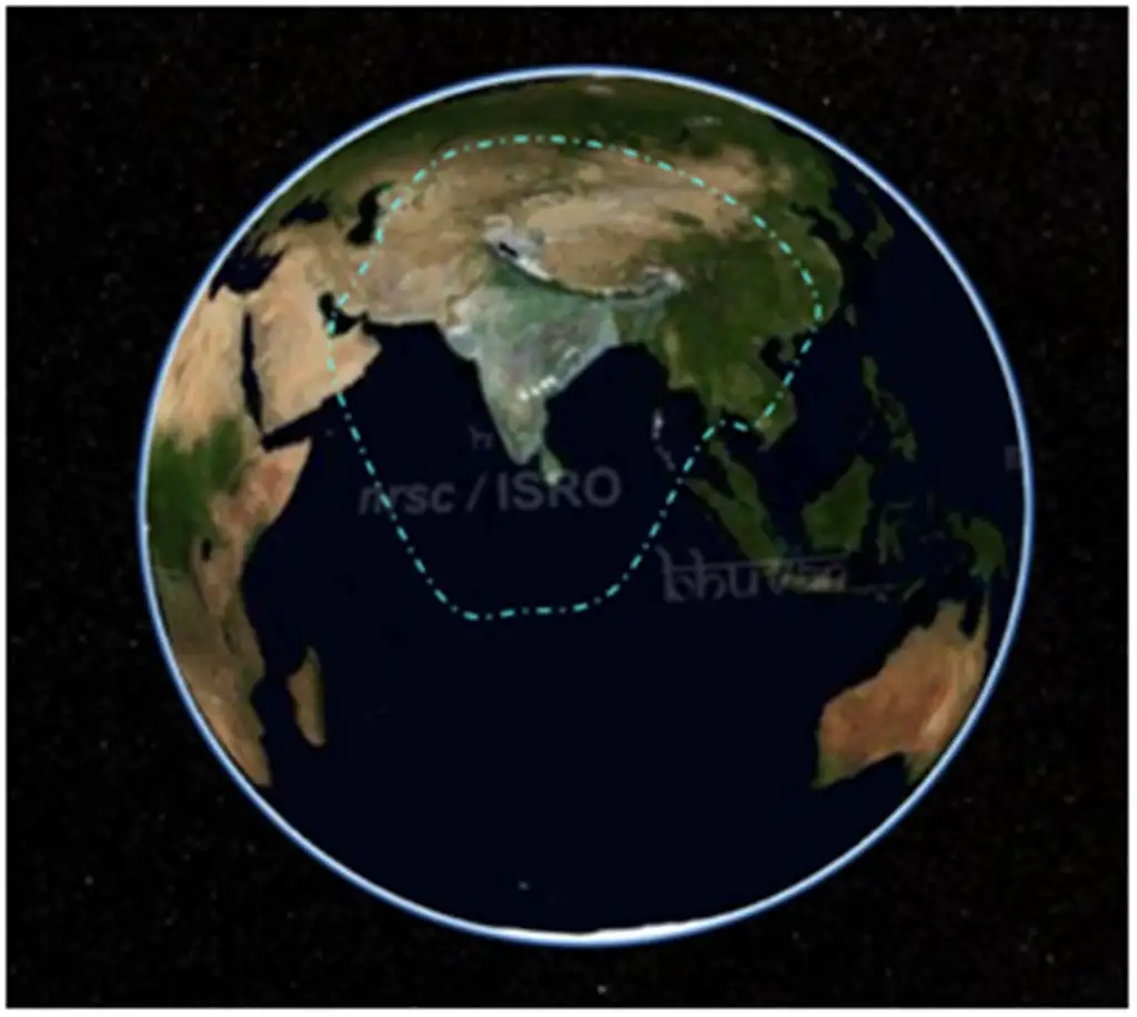
NAVIC is India's regional navigation system covering Indian subcontinent
GLONASS (Russia), Galileo (EU), BeiDou (China) are other major systems
Major GNSS Systems Comparison
System | Country/Region | Status | Coverage | Key Feature |
|---|---|---|---|---|
GPS | USA | Operational since 1995 | Global | Most widely used, 24+ satellites |
GLONASS | Russia | Operational since 1995 | Global | 24 satellites, works in polar regions |
Galileo | European Union | Operational since 2016 | Global | High precision, civilian controlled |
BeiDou | China | Global since 2020 | Global | 35 satellites, messaging capability |
NAVIC | India | Operational since 2018 | Regional (Indian Ocean) | 7 satellites, indigenous system |
India's NAVIC System
Full Name: Navigation with Indian Constellation (NAVIC), also called IRNSS (Indian Regional Navigation Satellite System)
Coverage: Extends 1,500 km beyond Indian borders, covering entire Indian subcontinent
Satellites: 7 satellites (3 geostationary, 4 geosynchronous orbits)
Accuracy: Better than 20 meters in primary service area
Strategic Importance: Reduces dependence on foreign GPS systems for critical applications
NAVIC Coverage
Source: ISRO — Satellite Navigation Services · www.isro.gov.in