The term 'M-STrIPES' is sometimes seen in the news in the context of
Contents16
- ACaptive breeding of Wild Fauna
- BMaintenance of Tiger Reserves
- CIndigenous Satellite Navigation System
- DSecurity of National Highways
Show answer
Answer: (B) Maintenance of Tiger Reserves
M-STrIPES stands for 'Monitoring System for Tigers – Intensive Protection and Ecological Status'.
It is a software-based patrolling and monitoring system launched by the Indian Government in 2010 for use in tiger reserves across India.
The system uses GPS-enabled devices (smartphones/tablets) to help field staff and forest managers track patrol routes, record wildlife sightings, monitor threats like poaching, and assess the intensity and spatial coverage of anti-poaching patrols using a Geographic Information System (GIS) platform.
Think of it as a high-tech upgrade to traditional foot-patrolling in tiger reserves.
The mobile app version was later officially launched at Corbett Tiger Reserve.
Option (a) is wrong — M-STrIPES is not about captive breeding of wild fauna.
Option (c) is wrong — it has nothing to do with satellite navigation systems (India's satellite navigation system is NavIC/IRNSS).
Option (d) is wrong — it has nothing to do with highway security. The name itself is a clue: 'STrIPES' clearly hints at tigers.
Key association:
- M-STrIPES = Tiger monitoring
- GPS + GIS patrolling in tiger reserves.
M-STrIPES is India's GPS-based patrolling system used across all tiger reserves to track anti-poaching efforts and monitor tiger populations since 2010.
The acronym STrIPES itself hints at tigers - this is UPSC testing whether students can decode the obvious clue in the name while knowing the technical details.
Questions like this check if students stay updated on wildlife conservation technology, not just traditional conservation concepts.
M-STrIPES Monitoring System
Environment M-STrIPES
M-STrIPES: Digital Tiger Monitoring & Anti-Poaching System
M-STrIPES = Monitoring System for Tigers – Intensive Protection and Ecological Status
GPS-enabled software system for patrolling and monitoring tiger reserves
Launched in 2010 by Indian Government, mobile app at Corbett Tiger Reserve
Uses GIS platform to track patrol routes and wildlife threats
What It Is
M-STrIPES is India's high-tech upgrade to traditional foot-patrolling in tiger reserves. Field staff use GPS-enabled smartphones and tablets to record their patrol activities in real-time, replacing paper-based logging with digital monitoring.
Key Features
Component | Function | Technology Used |
|---|---|---|
Patrol Tracking | Records patrol routes and coverage areas | GPS mapping |
Wildlife Sightings | Logs tiger and prey species observations | Digital forms + photos |
Threat Monitoring | Reports poaching, encroachment, forest fires | Real-time alerts |
Data Analysis | Assesses patrol intensity and effectiveness | GIS platform |
Why It Matters
Provides scientific data on patrol effectiveness instead of guesswork
Helps identify vulnerable zones where poaching incidents are high
Enables real-time coordination between forest staff and management
Creates digital database for long-term conservation planning
Question Context
UPSC tested this as a current affairs question about technology in conservation. The name itself is a clue — 'STrIPES' hints at tigers, making option B the logical choice over satellite navigation or highway security.
Trap: Confusing M-STrIPES with NavIC/IRNSS (India's satellite navigation system)
Trap: The 'M' in M-STrIPES stands for Monitoring, not Management or Mobile
Name association: STrIPES = Tigers, so eliminate non-tiger options immediately
Tiger Reserve Management in India
Environment Tiger Reserves
Tiger Reserves: Structure, Management & Conservation Framework
50+ tiger reserves across India under Project Tiger (1973)
Managed by NTCA (National Tiger Conservation Authority) under Ministry of Environment
Core + Buffer zone structure for habitat protection
Jim Corbett (1973) was India's first tiger reserve
Zone Structure
Zone Type | Activity Level | Human Settlement | Legal Status |
|---|---|---|---|
Core Zone | Minimal human activity | No settlements allowed | Critical Tiger Habitat under Wildlife Protection Act |
Buffer Zone | Limited eco-tourism | Existing settlements can continue | Tiger Reserve with regulated activities |
Transition Zone | Community participation | Villages and agriculture | Outside reserve boundaries |
Management Challenges
Human-wildlife conflict in buffer zones and corridors
Poaching pressure for tiger parts in illegal international trade
Habitat fragmentation due to development projects and roads
Prey depletion affecting tiger population sustainability
Tiger Reserve Distribution
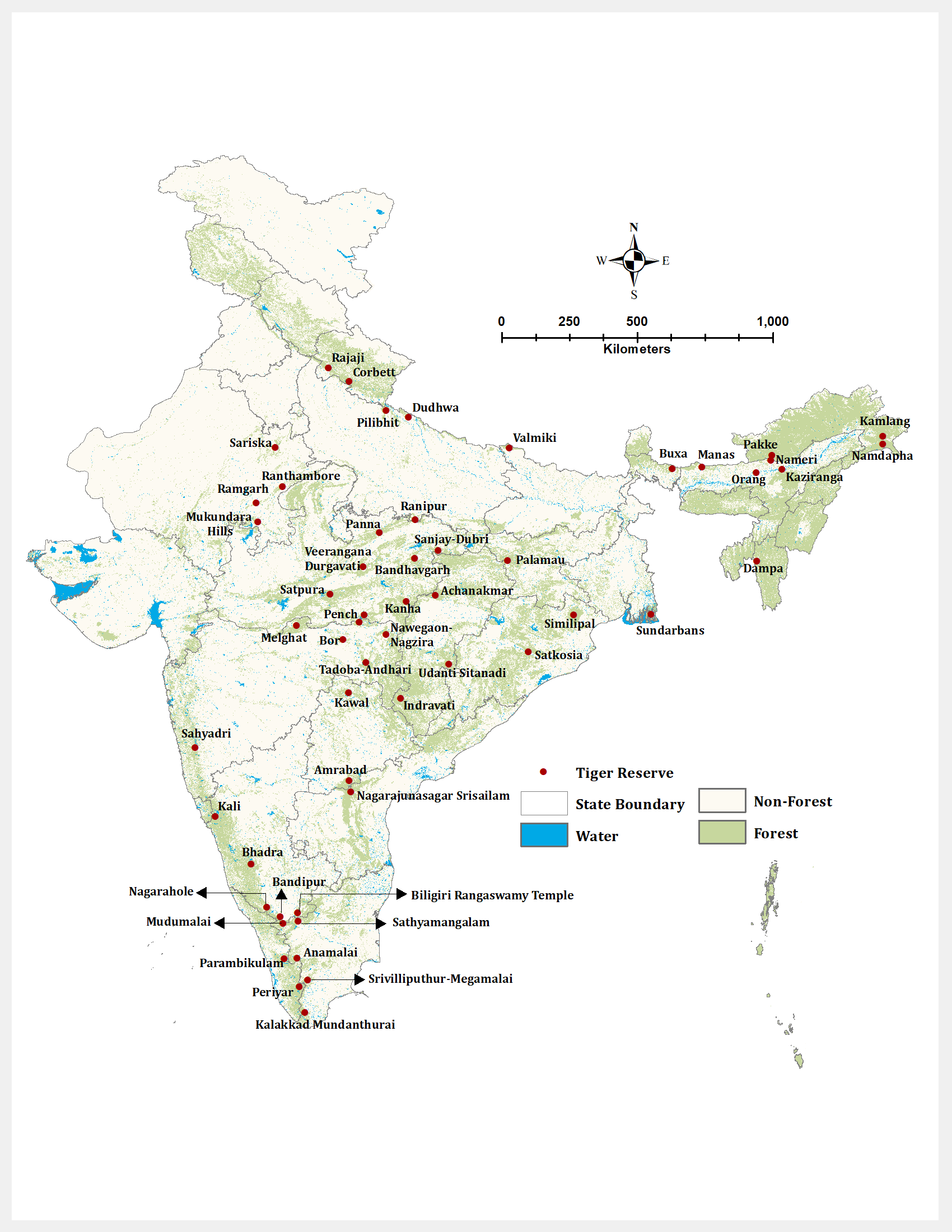
Source: Physics Wallah — Tiger Reserves in India, Complete List, Schemes, Map, Names · www.pw.live
Trap: NTCA manages tiger reserves, not CZA (Central Zoo Authority)
Trap: Core zones have NO human settlements, buffer zones can have existing ones
Remember: Project Tiger launched in 1973, not with Wildlife Protection Act (1972)
Technology in Wildlife Conservation
Environment
Modern Technology Tools for Wildlife Monitoring & Conservation
Camera traps for species identification and population counting
Satellite collaring for tracking animal movement patterns
Drone surveillance for anti-poaching and habitat monitoring
GIS mapping for habitat analysis and corridor planning
Conservation Technologies
Technology | Primary Use | Key Advantage | Example Application |
|---|---|---|---|
Camera Traps | Population monitoring | 24/7 automated surveillance | Tiger census every 4 years |
Satellite Collaring | Movement tracking | Real-time location data | Elephant corridor mapping |
M-STrIPES | Patrol monitoring | Digital patrol records | Tiger reserve anti-poaching |
Drones | Aerial surveillance | Large area coverage | Forest fire detection |
DNA Barcoding | Species identification | Genetic fingerprinting | Wildlife forensics |
Digital Conservation Benefits
Real-time data collection replaces manual, delayed reporting
Scientific accuracy in population estimates and habitat assessment
Evidence-based decisions for conservation strategy and resource allocation
Reduced human interference in sensitive wildlife areas
Don't confuse M-STrIPES (tiger monitoring) with camera trapping (species census)
GPS collaring tracks movement, camera traps count populations
GIS is the platform, GPS is the location technology — different tools
NavIC - India's Satellite Navigation
Science And Technology Indigenous Satellite Navigation System
NavIC (IRNSS): India's Regional Navigation Satellite System
NavIC = Navigation with Indian Constellation (formerly IRNSS)
7 satellites providing navigation services over India and region
Developed by ISRO, operational since 2018
3-meter accuracy over Indian subcontinent
Strategic Purpose
NavIC provides India with indigenous navigation capability, reducing dependence on foreign systems like GPS (US) or GLONASS (Russia). This ensures strategic autonomy in critical applications like defense and disaster management.
Global Navigation Systems
System | Country | Coverage | Satellites | Status |
|---|---|---|---|---|
GPS | USA | Global | 24+ | Operational since 1995 |
GLONASS | Russia | Global | 24+ | Operational since 1995 |
Galileo | European Union | Global | 30 | Operational since 2016 |
BeiDou | China | Global | 35 | Operational since 2020 |
NavIC | India | Regional | 7 | Operational since 2018 |
NavIC Applications
Disaster management and emergency response coordination
Transportation - fleet management, vehicle tracking
Agriculture - precision farming and land surveying
Defense applications - missile guidance, troop navigation
NavIC is India's navigation system, not M-STrIPES (tiger monitoring)
IRNSS was the old name, NavIC is the current brand name
NavIC is regional (India + 1500 km), not global like GPS