Consider the following states: 1. Chhattisgarh 2. Madhya Pradesh 3. Maharashtra 4. Odisha With reference to the States mentioned above, in terms of percentage of forest cover to the total area of State, which one of the following is the correct ascending order?
Contents16
- A2-3-1-4
- B2-3-4-1
- C3-2-4-1
- D3-2-1-4
Show answer
Answer: (C) 3-2-4-1
The correct answer is (C) — Maharashtra, Madhya Pradesh, Odisha, Chhattisgarh (in ascending order of forest cover percentage).
Maharashtra has about 16.5% forest cover,
Madhya Pradesh about 25.1%,
Odisha about 33%,
and Chhattisgarh about 41.1%.
So from least to most forested:
Maharashtra < MP < Odisha < Chhattisgarh.
Tip: Chhattisgarh is the most forested among these four.
Maharashtra, despite being large, has the least forest cover percentage.
Chhattisgarh has the highest forest cover percentage (around 41%) among all Indian states, while Maharashtra despite its size has only about 16% forest cover.
India State of Forest Report is released every two years by Forest Survey of India, making state-wise forest cover data a regular current affairs and static GK topic.
The question tests whether students can distinguish between absolute forest area versus percentage forest cover - a common UPSC trap across geography questions.
Forest Cover in Four Major States
Environment Chhattisgarh Madhya Pradesh Maharashtra Odisha forest cover percentage
Forest Cover Percentage: Chhattisgarh, MP, Maharashtra & Odisha
Chhattisgarh leads with 41.1% forest cover among these four states
Maharashtra has the lowest at 16.5% despite being a large state
Ascending order: Maharashtra < MP < Odisha < Chhattisgarh
Odisha has 33% and MP has 25.1% forest cover
Why This Ranking Matters
Forest cover percentage measures how much of a state's total area is under forest. This differs from absolute forest area — a smaller state like Chhattisgarh can have higher percentage coverage than larger states like Maharashtra.
Forest Cover Rankings
Rank | State | Forest Cover % | Key Characteristic |
|---|---|---|---|
1st (Highest) | Chhattisgarh | 41.1% | Most forested among the four |
2nd | Odisha | 33.0% | Rich biodiversity, tribal areas |
3rd | Madhya Pradesh | 25.1% | Large state with mixed terrain |
4th (Lowest) | Maharashtra | 16.5% | Urbanized, agricultural dominance |
Visual Forest Distribution
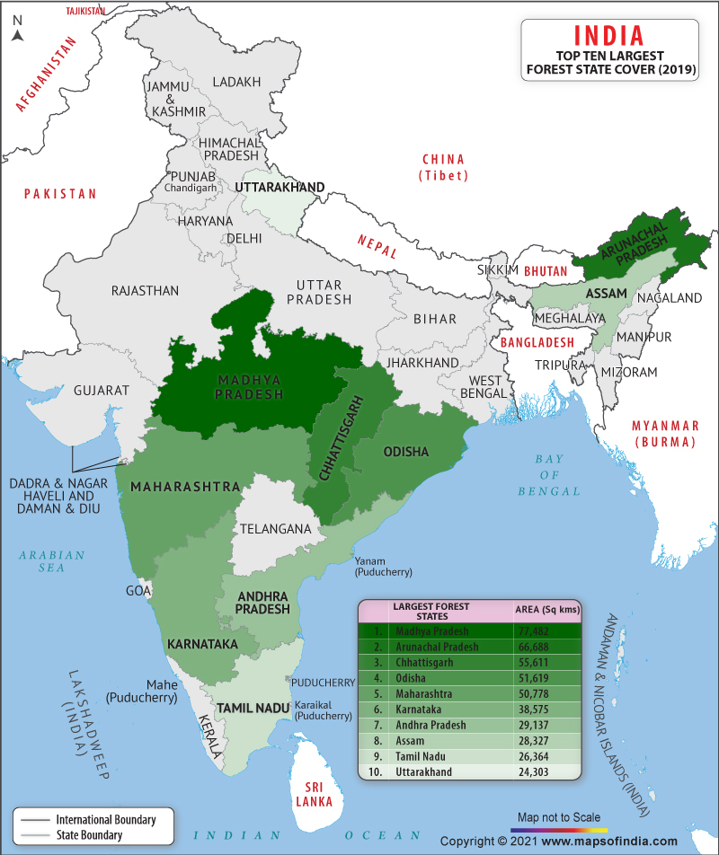
Source: India Map — States having largest forest cover in India · www.mapsofindia.com
Trap: Students often assume MP has highest forest cover because it's the largest among these four — but percentage matters, not absolute area
Trap: Maharashtra seems forested due to Western Ghats, but urbanization and agriculture keep its percentage low
Memory aid: Chhattisgarh is Champion in forest cover among these four
India State of Forest Report
Environment forest cover percentage
India State of Forest Report: Key Facts for UPSC
Published biennially by Forest Survey of India (FSI)
Measures forest cover, tree cover, and mangrove cover separately
Uses satellite imagery and ground surveys for accurate mapping
Mizoram has highest forest cover percentage in India (85%)
What FSI Measures
The report distinguishes between forest cover (land with tree patches ≥1 hectare and ≥10% tree canopy) and tree cover (scattered trees outside forests). This technical definition helps maintain consistent measurement across states.
Report Categories
Very Dense Forest: Canopy density >70%
Moderately Dense Forest: Canopy density 40-70%
Open Forest: Canopy density 10-40%
Scrub: Canopy density <10% but with forest species
Top Forest States
# India's Most Forested States
## By Percentage
- Mizoram (85%)
- Arunachal Pradesh (79%)
- Meghalaya (76%)
- Manipur (75%)
## By Area
- Madhya Pradesh
- Arunachal Pradesh
- Chhattisgarh
- Odisha
## Large States
- Chhattisgarh (41%)
- Odisha (33%)
- Karnataka (38%)
- Uttarakhand (45%)Trap: Don't confuse forest cover by area (MP leads) with forest cover by percentage (Mizoram leads)
Trap: Tree cover and forest cover are different categories in FSI reports
Chhattisgarh Forest Wealth
Environment Chhattisgarh
Why Chhattisgarh Leads in Forest Cover
41.1% forest cover makes it most forested among major states
Home to Sal, Teak, Bamboo forests across 3 forest zones
44% tribal population depends on forest resources
Part of Central Indian forest corridor linking various national parks
Geographic Advantage
Chhattisgarh's location in central India, with the Vindhyan and Satpura ranges, creates ideal conditions for dense forests. The state receives good rainfall and has relatively less industrial pressure compared to western states.
Key Forest Areas
Protected Area | District | Significance |
|---|---|---|
Kanger Ghati National Park | Bastar | Famous for underground caves and tribal culture |
Indravati National Park | Bijapur | Part of tiger conservation landscape |
Sitanadi Wildlife Sanctuary | Dhamtari | Buffer zone for tiger corridor |
Achanakmar Tiger Reserve | Bilaspur | Critical tiger habitat |
Economic Importance
Tendu leaves collection provides livelihood to lakhs of tribal families
Bamboo resources support paper and handicraft industries
Minor forest produce contributes significantly to tribal income
Forests act as carbon sinks and regulate local climate
Maharashtra's Limited Forest Cover
Environment Maharashtra
Why Maharashtra Has Low Forest Percentage
Only 16.5% forest cover despite being India's 3rd largest state
High urbanization and intensive agriculture reduce forest area
Forests mainly confined to Western Ghats and Vidarbha region
Sugarcane and cotton cultivation occupy large areas
Development Pressure
Maharashtra faces unique challenges — it's India's industrial hub with Mumbai-Pune corridor, extensive sugarcane belt, and high population density. This leaves limited land available for forests compared to less developed states.
Land Use Pattern
# Maharashtra Land Use
## Agriculture (60%)
- Sugarcane belt
- Cotton areas
- Jowar-Bajra zones
## Urban-Industrial
- Mumbai Metropolitan
- Pune-Nashik belt
- MIDC areas
## Forests (16.5%)
- Western Ghats
- Vidarbha forests
- Melghat Tiger Reserve
## Wasteland & Others
- Deccan plateau
- Rocky areas
- Saline patches
Key Forest Areas
Melghat Tiger Reserve in Vidarbha — state's premier tiger habitat
Western Ghats contain Sahyadri range forests with high endemism
Chandoli and Koyna sanctuaries protect watershed areas
Mangrove forests in Konkan coast face development pressure